Marpent
| Marpent | ||
|---|---|---|

|
|
|
| region | Hauts-de-France | |
| Department | North | |
| Arrondissement | Avesnes-sur-Helpe | |
| Canton | Eye of the mouth | |
| Community association | Maubeuge Val de Sambre | |
| Coordinates | 50 ° 18 ′ N , 4 ° 5 ′ E | |
| height | 122-195 m | |
| surface | 4.83 km 2 | |
| Residents | 2,748 (January 1, 2017) | |
| Population density | 569 inhabitants / km 2 | |
| Post Code | 59164 | |
| INSEE code | 59385 | |
| Website | http://www.marpent.fr/ | |
 Marpent City Hall |
||
Marpent is a French city with a population of 2,748 (as at 1st January 2017) in the department of Nord in the region of Hauts-de-France . Marpent belongs to the Arrondissement of Avesnes-sur-Helpe and the Canton of Maubeuge . The inhabitants are called Marpentois .
geography
Marpent is about seven kilometers east-northeast of Maubeuge on the canalized Sambre . Marpent is surrounded by the neighboring communities of Vieux-Reng in the north and north-west, Jeumont in the east, Colleret in the south, Recquignies in the south-west and Boussois in the west and north-west.
history
In Gallo-Roman times , Marpent was on the Roman road from Bavay to Trèves.
Population development
| 1962 | 1968 | 1975 | 1982 | 1990 | 1999 | 2006 | 2012 |
|---|---|---|---|---|---|---|---|
| 3.123 | 3,084 | 3,155 | 2,825 | 2,717 | 2,649 | 2,595 | 2,705 |
Attractions
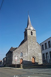
- Notre-Dame d'Ayde church (see also: Madonna and Child (Marpent) , monstrance reliquary (Marpent) and crucifixion scene (Marpent) )
- Cemetery with Cenotaph and British War Cemetery
- La Parapette Mill
- Park busses with fountain
- Lock on the Sambre
literature
- Le Patrimoine des Communes du Nord. Flohic Editions, Volume 2, Paris 2001, ISBN 2-84234-119-8 , pp. 1241-1242.
Web links
Commons : Marpent - collection of images, videos and audio files
- Monuments historiques (objects) in Marpent in the base Palissy of the French Ministry of Culture


