
Mecquignies
| Mecquignies | ||
|---|---|---|
.svg)
|
|
|
| region | Hauts-de-France | |
| Department | North | |
| Arrondissement | Avesnes-sur-Helpe | |
| Canton | Aulnoye Aymeries | |
| Community association | Pays de Mormal | |
| Coordinates | 50 ° 17 ′ N , 3 ° 48 ′ E | |
| height | 118-160 m | |
| surface | 4.78 km 2 | |
| Residents | 702 (January 1, 2017) | |
| Population density | 147 inhabitants / km 2 | |
| Post Code | 59570 | |
| INSEE code | 59396 | |
_mairie.JPG) Mairie Mecquignies |
||

Mecquignies is a municipality with 702 inhabitants (at January 1, 2017) in the French department of Nord in the region of Hauts-de-France . It belongs to the canton of Aulnoye-Aymeries (until 2015 canton Bavay ) in the arrondissement of Avesnes-sur-Helpe . It borders Bavay to the north, Audignies to the east, Locquignol to the south and Obies to the west .
The former Route nationale 32 leads via Mecquignies.
Population development
| year | 1962 | 1968 | 1975 | 1982 | 1990 | 1999 | 2008 | 2017 |
|---|---|---|---|---|---|---|---|---|
| Residents | 632 | 574 | 519 | 515 | 584 | 584 | 609 | 702 |
Attractions
- Church of Saint-Achard, Monument historique (see also: List of Monuments historiques in Mecquignies )
- War memorial
- Wayside shrines
- Model windmills in a garden
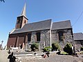
Saint-Achard church

annual medieval festival in Mecquignies

Model windmills
_%C3%A9glise,_vue_lat%C3%A9rale.JPG)

_model_windmills.JPG)
literature
- Le Patrimoine des Communes du Nord. Flohic Editions, Volume 1, Paris 2001, ISBN 2-84234-119-8 , pp. 235-237.
Web links
Commons : Mecquignies - collection of images, videos and audio files