Ferrière-la-Grande
| Ferrière-la-Grande | ||
|---|---|---|

|
|
|
| region | Hauts-de-France | |
| Department | North | |
| Arrondissement | Avesnes-sur-Helpe | |
| Canton | Eye of the mouth | |
| Community association | Maubeuge Val de Sambre | |
| Coordinates | 50 ° 15 ′ N , 4 ° 0 ′ E | |
| height | 127-184 m | |
| surface | 10.01 km 2 | |
| Residents | 5,301 (January 1, 2017) | |
| Population density | 530 inhabitants / km 2 | |
| Post Code | 59680 | |
| INSEE code | 59230 | |
| Website | http://www.ferrierelagrande.fr/ | |
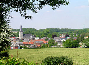
 View of Ferrière-la-Grande |
||
Ferrière-la-Grande is a French municipality with 5301 inhabitants (as of January 1 2017) in the department of Nord in the region Nord-Pas-de-Calais . The municipality belongs to the arrondissement of Avesnes-sur-Helpe and the canton of Maubeuge . The inhabitants are called Ferriérois (es) .
geography
Ferrière-la-Grand is located on the Solre and is surrounded by the neighboring municipalities of Rousies in the north, Cerfontaine in the northeast, Ferrière-la-Petite in the southeast, Beaufort in the south and southwest and Louvroil in the west and northwest.
The former Route nationale 49 runs through the municipality . Ferrière-la-Grande is on one of the Way of St. James ( Via Gallia Belgica ).
Population development
| 1962 | 1968 | 1975 | 1982 | 1990 | 1999 | 2006 | 2011 | |
|---|---|---|---|---|---|---|---|---|
| 5,263 | 5,346 | 5,703 | 5,611 | 5,746 | 5,672 | 5,481 | 5,415 | |
| Sources: Cassini and INSEE | ||||||||
Attractions
- Saint-Armand Church , built between 1872 and 1880
- Chapelle du Bon-Vouloir ( Saint-Dominique )
- Town hall from 1840
- Former train station
literature
- Le Patrimoine des Communes du Nord. Flohic Editions, Volume 2, Paris 2001, ISBN 2-84234-119-8 , pp. 1233-1234.
Web links
Commons : Ferrière-la-Grande - Collection of images, videos and audio files
- Monuments historiques (objects) in Ferrière-la-Grande in the base Palissy of the French Ministry of Culture


