Recquignies
| Recquignies | ||
|---|---|---|

|
|
|
| region | Hauts-de-France | |
| Department | North | |
| Arrondissement | Avesnes-sur-Helpe | |
| Canton | Fourmies | |
| Community association | Maubeuge Val de Sambre | |
| Coordinates | 50 ° 17 ′ N , 4 ° 3 ′ E | |
| height | 122-189 m | |
| surface | 6.17 km 2 | |
| Residents | 2,413 (January 1, 2017) | |
| Population density | 391 inhabitants / km 2 | |
| Post Code | 59245 | |
| INSEE code | 59495 | |
| Website | http://www.mairie-recquignies.fr/ | |
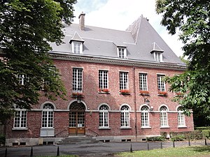
 Recquignies Town Hall |
||
Recquignies is a French commune with a population of 2,413 (as at 1st January 2017) in the department of Nord in the region of Hauts-de-France . The municipality belongs to the arrondissement of Avesnes-sur-Helpe and the canton of Fourmies (until 2015: canton of Maubeuge-Sud ).
geography
Recquignies is on the Sambre River . Recquignies is surrounded by the neighboring communities of Boussois in the north, Marpent in the east, Colleret in the south and south-east, Cerfontaine in the south-west, Rousies in the west and south-west and Assevent in the north-west.
Population development
| 1962 | 1968 | 1975 | 1982 | 1990 | 1999 | 2006 | 2012 | |
|---|---|---|---|---|---|---|---|---|
| 2,352 | 2,428 | 2,382 | 2,577 | 2,521 | 2,490 | 2,372 | 2,380 | |
| Sources: Cassini and INSEE | ||||||||
Attractions
- 19th century Saint-Sulpice church in Recquignies
- Saint-Martin church in the hamlet of Rocq, built in the early 16th century
- La Carnière Castle
literature
- Le Patrimoine des Communes du Nord. Flohic Editions, Volume 2, Paris 2001, ISBN 2-84234-119-8 , pp. 1248-1249.
Web links
Commons : Recquignies - collection of images, videos and audio files
- Monuments historiques (objects) in Recquignies in the base Palissy of the French Ministry of Culture


