
Liessies
| Liessies | ||
|---|---|---|
.svg)
|
|
|
| region | Hauts-de-France | |
| Department | North | |
| Arrondissement | Avesnes-sur-Helpe | |
| Canton | Fourmies | |
| Community association | Coeur de l'Avesnois | |
| Coordinates | 50 ° 7 ' N , 4 ° 5' E | |
| height | 157-234 m | |
| surface | 17.6 km 2 | |
| Residents | 533 (January 1, 2017) | |
| Population density | 30 inhabitants / km 2 | |
| Post Code | 59740 | |
| INSEE code | 59347 | |
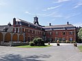
 Town hall (Mairie) of Liessies |
||

Liessies is a French municipality with 533 inhabitants (as of January 1 2017) in Nord in the region of Hauts-de-France . It belongs to the arrondissement of Avesnes-sur-Helpe and the canton of Fourmies (until 2015: canton of Solre-le-Château ). The inhabitants are called Laetitiens .
geography
Liessies is located about 19 kilometers south-southeast of Maubeuge on the Helpe Majeure . Neighboring communities of Liessies are Felleries in the north, Willies and Eppe-Sauvage in the east, Trélon in the south and south-east, Sains-du-Nord in the south and south-west and Ramousies in the west.
Population development
| year | 1962 | 1968 | 1975 | 1982 | 1990 | 1999 | 2006 | 2013 |
| Residents | 661 | 638 | 597 | 513 | 531 | 501 | 531 | 533 |
| Source: Cassini and INSEE | ||||||||
Attractions
See also: List of Monuments historiques in Liessies
- Saint-Jean church
- Saint-Lambert Church
- Chapel of Sainte-Hiltrude
- Remains of the former Benedictine monastery of Liessies, founded in 751
- La Motte Castle, now a hotel
- Bridge and mill on Helpe Majeure

Saint-Lambert Church

Lissies Monastery

Chapel of Sainte-Hiltrude
La Motte Castle

Bridge and mill on Helpe Majeure


_%C3%A9glise,_chevet.jpg)
_ch%C3%A2teau_de_la_Motte.jpg)
_pont_et_moulin_Helpe_Majeure.jpg)
literature
- Le Patrimoine des Communes du Nord. Flohic Editions, Volume 2, Paris 2001, ISBN 2-84234-119-8 , pp. 1532-1535.