
Celles (Dordogne)
|
Celles Cela |
||
|---|---|---|
|
||
| region | Nouvelle-Aquitaine | |
| Department | Dordogne | |
| Arrondissement | Périgueux | |
| Canton | Ribérac | |
| Community association | Pays Ribéracois | |
| Coordinates | 45 ° 18 ′ N , 0 ° 25 ′ E | |
| height | 61-213 m | |
| surface | 27.83 km 2 | |
| Residents | 587 (January 1, 2017) | |
| Population density | 21 inhabitants / km 2 | |
| Post Code | 24600 | |
| INSEE code | 24090 | |
| Website | http://www.celles24.fr/ | |

The French community Celles ( Occitan Cela ) is in the northwest of the department Dordogne in the region Nouvelle-Aquitaine (before 2016: Aquitaine ). It has 587 inhabitants (as of January 1, 2017) and belongs to the canton of Brantôme (until 2015: canton of Montagrier ). The inhabitants are called cellois .
geography
Celles is about 27 kilometers northwest of Périgueux (beeline). The Dronne limits the community in the south. Celles is surrounded by the neighboring communities of Coutures in the north and north-west, Bourg-des-Maisons in the north and north-east, Grand-Brassac in the east, Saint-Victor in the south-east, Saint-Méard-de-Dronne in the south, Villetoureix in the west and south-west as well Bertric-Burée in the west.
Population development
| year | 1962 | 1968 | 1975 | 1982 | 1990 | 1999 | 2006 | 2013 |
| Residents | 761 | 675 | 582 | 600 | 597 | 552 | 555 | 564 |
| Source: Cassini and INSEE | ||||||||
Attractions
- Saint-Pierre church from the 12th century, former priory church
- Saint-Jean-de-la-Lande chapel from the 14th century
- Sainte-Marie Chapel from the 17th century
- Lascoux Castle from the 16th century
- La Pauze castle from the 19th century

Saint-Pierre church
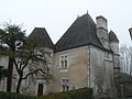
Lascoux Castle
_%C3%A9glise_(1).JPG)
_Lascoux.JPG)