
Dornholzhausen (Rhein-Lahn district)
| coat of arms | Germany map | |
|---|---|---|

|
Coordinates: 50 ° 16 ' N , 7 ° 47' E |
|
| Basic data | ||
| State : | Rhineland-Palatinate | |
| County : | Rhein-Lahn district | |
| Association municipality : | Bad Ems-Nassau | |
| Height : | 305 m above sea level NHN | |
| Area : | 3.93 km 2 | |
| Residents: | 195 (Dec. 31, 2019) | |
| Population density : | 50 inhabitants per km 2 | |
| Postal code : | 56357 | |
| Area code : | 02604 | |
| License plate : | EMS, DIZ, GOH | |
| Community key : | 07 1 41 033 | |
| Association administration address: | Am Adelsheimer Hof 1 56377 Nassau |
|
| Website : | ||
| Mayoress : | Ilona Koehler-Heymann | |
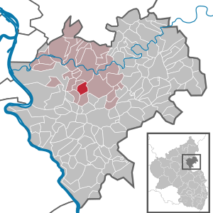
| Location of the local community Dornholzhausen in the Rhein-Lahn district | ||
  |
||

Dornholzhausen is a municipality in the Rhein-Lahn district in Rhineland-Palatinate . It belongs to the Bad Ems-Nassau community .
geography
The place is on the Unterlahnhöhen in the western Hintertaunus in the Nassau nature park . The highest point is the Köppel (336 m above sea level).
history
The place was first mentioned in 1260 under the name "Durrenholzhusen". Dornholzhausen was since the 12th century in the condominium later called " Vierherrisches auf dem Einrich " , which was jointly owned by Hessen-Kassel and various lines from Nassau . Dornholzhausen was assigned to the Nassau-Saarbrückisches Quartier.
The Reformation was introduced around 1540, and the clashes between Lutherans and Reformed people continued for a long time. In 1608 the pastor Heinrich Jakob Piskator from Dornholzhausen was stabbed to death by his predecessor in a dispute. In 1725 the pastors Heinicus were killed by robbery. Dessighofen and Geisig also belonged to the parish of Dornholzhausen .
After the division of the "Vierherrischen" in 1774, the place came under the joint sovereignty of Nassau-Usingen and Nassau-Diez and was assigned to the Nassau office. From 1806 the place belonged to the Duchy of Nassau , which was annexed by the Kingdom of Prussia in 1866 . Dornholzhausen came in 1868 to the Prussian province of Hessen-Nassau . After the First World War , the place was occupied until the French withdrew in 1929. After the Second World War , the place was also in the French occupation zone and in 1946 became part of the state of Rhineland-Palatinate .
From 1986 a village renewal was carried out in Dornholzhausen.
The population developed as follows in the 19th and 20th centuries: 1843: 199 inhabitants, 1927: 210 inhabitants, 1964: 188 inhabitants.
politics
Municipal council
The council in Dornholzhausen consists of six council members, who in the local elections on May 26, 2019 in a majority vote were elected, and the volunteer local mayor as chairman.
mayor
The local mayor of Dornholzhausen is Ilona Köhler-Heymann. In the direct election on May 26, 2019, she was re-elected with 85.27% of the vote.
coat of arms
The coat of arms, which has been in use since 1991, shows "a green deciduous tree with roots in gold, accompanied by 2 red ears of wheat at the bottom right and left."
Attractions
- the baroque Protestant parish church
- the Martin Luther Oak
See also:
Web links
- Dornholzhausen parish
- Local community Dornholzhausen on the website of the Bad Ems-Nassau community
- Chronicle of the Dornholzhausen community (PDF file; 4.2 MB)
Individual evidence
- ↑ State Statistical Office of Rhineland-Palatinate - population status 2019, districts, communities, association communities ( help on this ).
- ↑ Anton Joseph Weidenbach : Nassau territories from the property holdings immediately before the French Revolution until 1866 , Wiesbaden: Stein, 1870, p. 29 ( dilibri.de )
- ↑ Helfrick Bernhard Wenck: Hessische Landes Geschichte: Mit Urkundenbuch , Volume 1, 1783, S. LVI ( Google Books )
- ^ The Regional Returning Officer Rhineland-Palatinate: Local council election 2019 Dornholzhausen. Retrieved November 3, 2019 .
- ^ The Regional Returning Officer Rhineland-Palatinate: direct elections 2019. see Bad Ems-Nassau, Verbandsgemeinde, seventh line of results. Retrieved November 3, 2019 .

Allendorf | Altendiez | Arzbach | Attenhausen | Auel | Aull | Bad Ems | Balduinstein | Becheln | Mountain | Berghausen | Berndroth | Bettendorf | Biebrich | Birlenbach | Bogel | Bornich | Braubach | Bremberg | Book | Burgschwalbach | Charlottenberg | Cramberg | Dachsenhausen | Dahlheim | Dausenau | Dessighofen | Dienethal | Diethardt | Diez | Dörnberg | Dornholzhausen | Dörscheid | Dörsdorf | Ebertshausen | Honor | Eisighofen | Endlichhofen | Eppenrod | Ergeshausen | Eschbach | Fachbach | Filsen | Flat | Fruit | Geilnau | Geisig | Gemmerich | Gückingen | Gutenacker | Hahnstätten | Hainau | Hambach | Heistenbach | Herald | Himmighofen | Hirschberg | Holzappel | Holzhausen an der Haide | Holzheim | Hömberg | Horhausen | Hunzel | Isselbach | Kaltenholzhausen | Kamp-Bornhofen | Kasdorf | Katzenelnbogen | Kaub | Kehlbach | Kemmenau | Kestert | Klingelbach | Kördorf | Lahnstein | Langenscheid | Laurenburg | Lautert | Liiffer | Lipporn | Lohrheim | Lollschied | Lykershausen | Marienfels | Miehlen | Mielle | Misselberg | Mittelfischbach | Mudershausen | Nassau | Nasta | Netzbach | Niederbachheim | Niederneisen | Niedertiefenbach | Niederwallmenach | Never | Nochern | Oberbachheim | Oberfischbach | Oberneisen | Obernhof | Obertiefenbach | Oberwallmenach | Oberwies | Oelsberg | Osterspai | Patersberg | Pohl | Prath | Reckenroth | Reichenberg | Reitzenhain | Rescue Grove | Rescues | Roth | Ruppertshofen | Sankt Goarshausen | Sauerthal | Scheidt | Schiesheim | Schönborn | Schweighausen | Seelbach | Singhofen | Steinsberg | Strüth | Sulzbach | Wasenbach | Weidenbach | Weinähr | Weisel | World destruction | Weyer | Winches | Winter advertising | Room difference