
Autobahn 2 (Switzerland)
| Autobahn 2 in Switzerland | |||||||||||||||||||||||||||||||||||||||||||||||||||||||||||||||||||||||||||||||||||||||||||||||||||||||||||||||||||||||||||||||||||||||||||||||||||||||||||||||||||||||||||||||||||||||||||||||||||||||||||||||||||||||||||||||||||||||||||||||||||||||||||||||||||||||||||||||||||||||||||||||||||||||||||||||||||||||||||||||||||||||||||||||||||||||||||||||||||||||||||||||||||||||||||||||||||||||||||||||||||||||||||||||||||||||||||||||||||||||||||||||||||||||||||||||||||||||||||||||||||||||||||||||||||||||||||||||||||||||||||||||||||||||||||||||||||||||||||||||||||||||||||||||||||||||

|
|||||||||||||||||||||||||||||||||||||||||||||||||||||||||||||||||||||||||||||||||||||||||||||||||||||||||||||||||||||||||||||||||||||||||||||||||||||||||||||||||||||||||||||||||||||||||||||||||||||||||||||||||||||||||||||||||||||||||||||||||||||||||||||||||||||||||||||||||||||||||||||||||||||||||||||||||||||||||||||||||||||||||||||||||||||||||||||||||||||||||||||||||||||||||||||||||||||||||||||||||||||||||||||||||||||||||||||||||||||||||||||||||||||||||||||||||||||||||||||||||||||||||||||||||||||||||||||||||||||||||||||||||||||||||||||||||||||||||||||||||||||||||||||||||||||||
| |
|||||||||||||||||||||||||||||||||||||||||||||||||||||||||||||||||||||||||||||||||||||||||||||||||||||||||||||||||||||||||||||||||||||||||||||||||||||||||||||||||||||||||||||||||||||||||||||||||||||||||||||||||||||||||||||||||||||||||||||||||||||||||||||||||||||||||||||||||||||||||||||||||||||||||||||||||||||||||||||||||||||||||||||||||||||||||||||||||||||||||||||||||||||||||||||||||||||||||||||||||||||||||||||||||||||||||||||||||||||||||||||||||||||||||||||||||||||||||||||||||||||||||||||||||||||||||||||||||||||||||||||||||||||||||||||||||||||||||||||||||||||||||||||||||||||||
| map | |||||||||||||||||||||||||||||||||||||||||||||||||||||||||||||||||||||||||||||||||||||||||||||||||||||||||||||||||||||||||||||||||||||||||||||||||||||||||||||||||||||||||||||||||||||||||||||||||||||||||||||||||||||||||||||||||||||||||||||||||||||||||||||||||||||||||||||||||||||||||||||||||||||||||||||||||||||||||||||||||||||||||||||||||||||||||||||||||||||||||||||||||||||||||||||||||||||||||||||||||||||||||||||||||||||||||||||||||||||||||||||||||||||||||||||||||||||||||||||||||||||||||||||||||||||||||||||||||||||||||||||||||||||||||||||||||||||||||||||||||||||||||||||||||||||||
 |
|||||||||||||||||||||||||||||||||||||||||||||||||||||||||||||||||||||||||||||||||||||||||||||||||||||||||||||||||||||||||||||||||||||||||||||||||||||||||||||||||||||||||||||||||||||||||||||||||||||||||||||||||||||||||||||||||||||||||||||||||||||||||||||||||||||||||||||||||||||||||||||||||||||||||||||||||||||||||||||||||||||||||||||||||||||||||||||||||||||||||||||||||||||||||||||||||||||||||||||||||||||||||||||||||||||||||||||||||||||||||||||||||||||||||||||||||||||||||||||||||||||||||||||||||||||||||||||||||||||||||||||||||||||||||||||||||||||||||||||||||||||||||||||||||||||||
| Basic data | |||||||||||||||||||||||||||||||||||||||||||||||||||||||||||||||||||||||||||||||||||||||||||||||||||||||||||||||||||||||||||||||||||||||||||||||||||||||||||||||||||||||||||||||||||||||||||||||||||||||||||||||||||||||||||||||||||||||||||||||||||||||||||||||||||||||||||||||||||||||||||||||||||||||||||||||||||||||||||||||||||||||||||||||||||||||||||||||||||||||||||||||||||||||||||||||||||||||||||||||||||||||||||||||||||||||||||||||||||||||||||||||||||||||||||||||||||||||||||||||||||||||||||||||||||||||||||||||||||||||||||||||||||||||||||||||||||||||||||||||||||||||||||||||||||||||
| Operator: | Federal Roads Office | ||||||||||||||||||||||||||||||||||||||||||||||||||||||||||||||||||||||||||||||||||||||||||||||||||||||||||||||||||||||||||||||||||||||||||||||||||||||||||||||||||||||||||||||||||||||||||||||||||||||||||||||||||||||||||||||||||||||||||||||||||||||||||||||||||||||||||||||||||||||||||||||||||||||||||||||||||||||||||||||||||||||||||||||||||||||||||||||||||||||||||||||||||||||||||||||||||||||||||||||||||||||||||||||||||||||||||||||||||||||||||||||||||||||||||||||||||||||||||||||||||||||||||||||||||||||||||||||||||||||||||||||||||||||||||||||||||||||||||||||||||||||||||||||||||||||
| Start of the street: |
Basel ( 47 ° 35 ′ N , 7 ° 36 ′ E ) |
||||||||||||||||||||||||||||||||||||||||||||||||||||||||||||||||||||||||||||||||||||||||||||||||||||||||||||||||||||||||||||||||||||||||||||||||||||||||||||||||||||||||||||||||||||||||||||||||||||||||||||||||||||||||||||||||||||||||||||||||||||||||||||||||||||||||||||||||||||||||||||||||||||||||||||||||||||||||||||||||||||||||||||||||||||||||||||||||||||||||||||||||||||||||||||||||||||||||||||||||||||||||||||||||||||||||||||||||||||||||||||||||||||||||||||||||||||||||||||||||||||||||||||||||||||||||||||||||||||||||||||||||||||||||||||||||||||||||||||||||||||||||||||||||||||||
| End of the road: |
Chiasso ( 45 ° 50 ′ N , 9 ° 2 ′ E ) |
||||||||||||||||||||||||||||||||||||||||||||||||||||||||||||||||||||||||||||||||||||||||||||||||||||||||||||||||||||||||||||||||||||||||||||||||||||||||||||||||||||||||||||||||||||||||||||||||||||||||||||||||||||||||||||||||||||||||||||||||||||||||||||||||||||||||||||||||||||||||||||||||||||||||||||||||||||||||||||||||||||||||||||||||||||||||||||||||||||||||||||||||||||||||||||||||||||||||||||||||||||||||||||||||||||||||||||||||||||||||||||||||||||||||||||||||||||||||||||||||||||||||||||||||||||||||||||||||||||||||||||||||||||||||||||||||||||||||||||||||||||||||||||||||||||||
| Overall length: | approx. 295 km | ||||||||||||||||||||||||||||||||||||||||||||||||||||||||||||||||||||||||||||||||||||||||||||||||||||||||||||||||||||||||||||||||||||||||||||||||||||||||||||||||||||||||||||||||||||||||||||||||||||||||||||||||||||||||||||||||||||||||||||||||||||||||||||||||||||||||||||||||||||||||||||||||||||||||||||||||||||||||||||||||||||||||||||||||||||||||||||||||||||||||||||||||||||||||||||||||||||||||||||||||||||||||||||||||||||||||||||||||||||||||||||||||||||||||||||||||||||||||||||||||||||||||||||||||||||||||||||||||||||||||||||||||||||||||||||||||||||||||||||||||||||||||||||||||||||||
| of which in operation: | approx. 295 km | ||||||||||||||||||||||||||||||||||||||||||||||||||||||||||||||||||||||||||||||||||||||||||||||||||||||||||||||||||||||||||||||||||||||||||||||||||||||||||||||||||||||||||||||||||||||||||||||||||||||||||||||||||||||||||||||||||||||||||||||||||||||||||||||||||||||||||||||||||||||||||||||||||||||||||||||||||||||||||||||||||||||||||||||||||||||||||||||||||||||||||||||||||||||||||||||||||||||||||||||||||||||||||||||||||||||||||||||||||||||||||||||||||||||||||||||||||||||||||||||||||||||||||||||||||||||||||||||||||||||||||||||||||||||||||||||||||||||||||||||||||||||||||||||||||||||
|
Canton : |
|
||||||||||||||||||||||||||||||||||||||||||||||||||||||||||||||||||||||||||||||||||||||||||||||||||||||||||||||||||||||||||||||||||||||||||||||||||||||||||||||||||||||||||||||||||||||||||||||||||||||||||||||||||||||||||||||||||||||||||||||||||||||||||||||||||||||||||||||||||||||||||||||||||||||||||||||||||||||||||||||||||||||||||||||||||||||||||||||||||||||||||||||||||||||||||||||||||||||||||||||||||||||||||||||||||||||||||||||||||||||||||||||||||||||||||||||||||||||||||||||||||||||||||||||||||||||||||||||||||||||||||||||||||||||||||||||||||||||||||||||||||||||||||||||||||||||
|
Course of the road
|
|||||||||||||||||||||||||||||||||||||||||||||||||||||||||||||||||||||||||||||||||||||||||||||||||||||||||||||||||||||||||||||||||||||||||||||||||||||||||||||||||||||||||||||||||||||||||||||||||||||||||||||||||||||||||||||||||||||||||||||||||||||||||||||||||||||||||||||||||||||||||||||||||||||||||||||||||||||||||||||||||||||||||||||||||||||||||||||||||||||||||||||||||||||||||||||||||||||||||||||||||||||||||||||||||||||||||||||||||||||||||||||||||||||||||||||||||||||||||||||||||||||||||||||||||||||||||||||||||||||||||||||||||||||||||||||||||||||||||||||||||||||||||||||||||||||||
The Highway 2 , also Gotthard route or Gotthard motorway called, is a Swiss motorway , by the German border at Basel via Lucerne through the Gotthard and Lugano to the Italian border at Chiasso leads.
It represents the most important corridor connection through the Swiss Alps and, along with the Austrian Brenner motorway and the French Mont-Blanc motorway, is one of the most important north-south traffic axes in Europe. Because of this, it is one of the busiest motorways in Switzerland. At the same time it is on its whole length part of the European Strasse 35 ( Amsterdam - Rome ) and between Basel and Rothrist of Europe Strasse 25 , of Hoek van Holland to Palermo leads.
A section of the A2 near Horw south of Lucerne is the oldest motorway in Switzerland. It was opened in 1955 as the main road Lucerne-South .
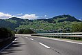
Route
Basel (D / CH border) - Härkingen junction
The A2 starts at the Basel / Weil am Rhein border crossing on the border with Germany, where it is the continuation of the German federal motorway 5 . After crossing the Basel district of Kleinhüningen on an elevated road, the A3 coming from the French border near St. Louis joins the Wiese junction in a southerly direction and runs on the same route as the A2 to Augst . Immediately afterwards, the forecourt of the Baden train station is driven under in a tunnel and the Rhine is crossed on the Black Forest Bridge together with the railway line leading away from the station . On a short stretch to the south of the bridge, the railroad tracks run along the widened median, before the motorway at the Basel-Süd / City junction, which resembles a motorway triangle, swings to the east. There is a left exit in the direction of Germany.
At the Hagnau junction, a complex motorway junction with an integrated junction, there is the option of changing to main road 18 in the direction of Delsberg , which is developed like a motorway to Reinach . Behind the junction, the Muttenz freight yard and the Schweizerhalle chemical park are crossed in a tunnel . The junction with the A3 ends at the Augst junction, which continues to Zurich ; the A2 itself turns south again into the Jura .
The section from Augst to Härkingen at the southern foot of the Jura , where the A2 meets the A1 , runs in the northern part through valleys in the Folded Jura and in the south through the mountains of the Folded Jura. In these mountains the motorway runs through several tunnels. After the approximately 3 km long Belchen tunnel between Eptingen and Hägendorf , the route descends over a long ramp into the plateau of the Swiss Plateau .

Meadow branch with the confluence of the Basler Nordtangente

Rest area Pratteln east of Basel

North portal of the Belchen tunnel


Härkingen branch - Lopper branch
Between the Härkingen junction and the Wiggertal junction to the east, the A2 runs together with the A1 ( Geneva - Bern - Zurich - St. Gallen ) on a shared, six-lane route that crosses the Aare at Rothrist . From there to Lucerne, the motorway then leads across the Mittelland, first through the Wiggertal and then on the east side of the Sempachersee from Sursee to Sempach and reaches the greater Lucerne area near Emmen .
At the Rotsee junction you cross the Reuss and the A14 coming from Zug or the Rütihof junction joins the A2. On viaducts, in noise protection galleries and several tunnels, the motorway crosses the moraine and molasse hills in the north-western area of Lake Lucerne and the city of Lucerne with its suburbs. The Sonnenberg tunnel between Lucerne and Kriens was originally also equipped as a civil defense system for 20,000 residents of the city of Lucerne and was the largest of its kind in Europe until it was reduced to a corresponding seven-story cavern in 2006.
South of Hergiswil branched at the partially erected in several tunnels branching Lopper a spur of, Pilate , the A8 over the Brünigpass to Interlaken from.

South portal of the Sonnenberg tunnel in Lucerne

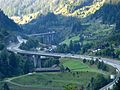
Hergiswil - Airolo
In the foothills of the Alps around Stans and Beckenried , the course of the road repeatedly reaches Lake Lucerne in several places . At Beckenried, the motorway lies on the steep, unstable slope of the Beckenried mountain on the second longest viaduct in Switzerland, the Beckenried viaduct . It leads in a wide arc through the approximately 9 km long Seelisberg tunnel to Seedorf in the canton of Uri and there along the Urnersee to the junction of autostrasse 4 from Flüelen to Schwyz .
The motorway initially runs through the Urner Reuss plain next to the Reuss Canal, before the uphill stretch, which has a lot of engineering structures, begins at Amsteg . At Erstfeld it crosses under the debris fan of the Alpbach . If the road from Altdorf to Amsteg only rises around 70 meters, the significantly steeper access ramp to the Gotthard road tunnel with numerous other tunnels and a few viaducts begins in front of the Plattitunnel .
In Göschenen the north portal of the Gotthard tunnel is located. This has only one tube and therefore only one lane in both directions. Therefore, the section in the tunnel, the only one on the entire route, is not considered a motorway, but a car road. The structure is the third longest road tunnel in the world (after the Lærdals tunnel in Norway and the Zhongnanshan tunnel in the People's Republic of China ). In the middle of the tunnel, the motorway crosses the border from the canton of Uri into the canton of Ticino . The continental watershed lies on the mountains of the Gotthard massif .

At the Urnersee, left the Gitschen
On the south bank of Lake Lucerne between Buochs (34) and Beckenried (35)

Beckenried Lehnen Viaduct

North portal of the Seelisberg tunnel
Curvy ascent from the north portal of the Gotthard road tunnel

Northern entrance to the Gotthard tunnel

.jpg)


.jpg)
Airolo - Chiasso (border CH / I)
From Airolo , the motorway lies on the western slope above the Ticino river in the Leventina . It leads through numerous tunnels and over several viaducts. The tallest structure is the Biaschina Viaduct near Giornico , where the A2 crosses the valley. After Biasca the A2 runs in the flat valley floor and you reach the capital of the canton Ticino, Bellinzona , where the A13 joins from San Bernardino .
The valley now opens wider and wider and before Locarno it goes up the northern slope of Monte Ceneri , with a view of the entire Magadino plain and Lake Maggiore . After the Monte Ceneri tunnel and a few other motorway tunnels, you finally reach Lugano and drive over the picturesque dam that divides Lake Lugano along the Mediterranean shore towards Chiasso , where the motorway leaves Switzerland. Across the border with Italy , the A9 autostrada continues towards Milan .

Junction Quinto (42)
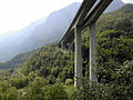
Biaschina viaduct of the A2, view in south direction

Mountain panorama in the Leventina Valley

South portal of the Monte Ceneri tunnel

South of Lugano

Chiasso / Brogeda border crossing to Italy


.jpg)


history
prehistory
The Alpine crossing on the Gotthard , which they called Adula Mons (steep mountain) or Mons Tremor (trembling mountain), was already used by traders and the military in Roman times . For a long time, however, the importance of the pass remained rather minor, as the Schöllenen Gorge was an almost insurmountable obstacle.
It was only in the Middle Ages, after the first Devil's Bridge was completed over the Schöllenen Gorge in 1230 , that the importance of the Alpine crossing increased. The second bridge over the gorge was built in 1595. The first paved road for stagecoach traffic over the pass was finally opened in 1831. With the advent of the railroad and the opening of the Gotthard tunnel on the Immensee-Chiasso (Gotthard Railway) line in 1882, however, the stagecoach lost its importance again. After the first automobile drove over the pass in 1895, it wasn't until 1953 that construction of a new road over the Gotthard, designed for car traffic, began.
The main road Luzern-Süd
The first built forerunner of today's A2 was also the first motorway in Switzerland. The Lucerne-South arterial road, opened on June 11, 1955, led from Eichhof at what is now the Luzern- Kriens junction to Ennethorw and served to bypass the southern Lucerne suburb of Horw . Contrary to today's standards, it only had very short entrances and exits, for the most part no lane markings and no safety precautions such as hard shoulder or crash barriers. It also had a pedestrian crossing and cycle paths on both sides of the street. It was also not completely free of height .
In 1958, a referendum approved the construction of a nationwide network of national highways after private traffic rose rapidly as a result of the economic miracle. The National Road Act of June 21, 1960 provided for the establishment of a main axis through the Mittelland (N1) from Geneva via Lausanne, Bern and Zurich to Lake Constance , but there was no plan for a north-south connection from Basel to Chiasso. It was not until 1965, following the recommendation of a working group founded five years earlier, that the federal councils decided to expand the national road network with a road tunnel under the Gotthard. A ventilated road tunnel with portals in Göschenen and Airolo was chosen from among several possible variants.
Construction of the national road 2
The Hergiswil – Stansstad section, which connects directly to the Lucerne-South arterial road, was opened in 1965; in 1969 it reached as far as Stans, 1970 to Buochs and 1974 to Beckenried.
Individual sections in the canton of Ticino were completed in the 1960s north and south of Lugano with continuation to the Italian border at Chiasso and at Bellinzona as a bypass of the canton's capital. The Basel – Augst section built as part of the N3 was opened to traffic as early as 1969.
The Belchen tunnel forms the central part of the section in the Jura between Augst and Härkingen. The approximately 3 km long tunnel was built from 1963 to 1970 and opened in December 1970 together with the section of the A2.
Closing gaps and completion
The official start of construction of the Gotthard road tunnel was on May 5, 1970. Ten years later, on September 5, 1980, it was opened to traffic by Federal Councilor Hans Hürlimann at 5 p.m. The northern feeder route from Altdorf was built in the 1970s.
The 9.3 km long Seelisberg tunnel was built from 1971 and also opened in 1980. In contrast to the Gotthard road tunnel to the south, it was equipped with two tubes; the N2 is here completely expanded as a four-lane motorway. It connects the cantons of Nidwalden and Uri and thus the Mittelland with the Gotthard. The Beckenried Lehnen Viaduct connects directly to the western tunnel portal, which at the time of construction was the longest bridge in Switzerland with a total length of more than 3 km. This record was adopted four years later by the Viaduc d'Yverdon on the A5 . With the opening of this section, the N2 between Lucerne and the Gotthard tunnel was complete.
The city transit of Basel was built in sections from 1971 to 1974.
In 1980 and 1981, the section through the Central Plateau from the Wiggertal junction to Emmen north of Lucerne was opened. In 1980, the Basel / Weil am Rhein border crossing to the German federal motorway 5 was built.
After the section in the Leventina from Airolo to Bellinzona was completed from 1980 to 1986 and the demanding route on Monte Ceneri in 1983, the entire length of the motorway was drivable. Especially in the Leventina, the construction of the motorway was expensive and time-consuming, as there was a long-running dispute over the route. It leads through numerous tunnels and over viaducts, of which the Biaschina viaduct is the second highest bridge structure in Switzerland with a height of 100 m.
In the course of the change in street numbering in 1996, the name of the route previously run as N2 was changed to A2.
Expansion and traffic
Almost its entire length of the A2 is developed as a multi-lane motorway with at least four lanes. Only the section through the Gotthard road tunnel between the Göschenen and Airolo junctions is a non-directional road, which is why there are often long queues in front of the portals when there is high traffic, especially at Easter or during the summer holidays. There, traffic lights can be used to meter the volume of traffic in order to prevent congestion inside the tunnel. The heavy traffic will only drop by drop admitted.
Other bottlenecks are the Basel area, where the A2 is also used by the A3 , and the section between the Härkingen and Wiggertal junctions, where the A1 is also used. The use of heavier vehicles (40 tons instead of 28 tons), which has been possible since 2001 due to the land transport agreement with the European Union, is an additional burden on the sometimes fragile traffic artery. Because of this, sections of the road were and are continuously being expanded.
Belchen renovation tunnel
The Belchen Tunnel, opened in 1970, is currently in urgent need of renovation, as the swelling of the gypsum keuper is causing damage to the supporting structure of the tunnel. In order to hinder the traffic as little as possible during this work, a tunnel tube is currently being built parallel to the existing one by 2022 (so-called renovation tunnel ). During the work carried out one after the other in the existing tunnels, this will lead traffic to the south. After the work has been completed, however, only two tubes remain available for traffic.
Six-lane expansion Härkingen - Wiggertal
The 9 km long section between the Härkingen and Wiggertal junctions, on which the A2 runs together with the A1, accommodates north-south traffic between Germany and Italy as well as traffic between the Swiss metropolitan areas of Geneva, Bern and Zurich and is therefore heavily loaded. From 2012 to 2014 the motorway was therefore expanded from four to six lanes.
Lucerne bypass
In the Lucerne area, the A2 runs through the middle of the densely built-up urban area and, in addition to long-distance traffic, also includes the A14 traffic from Zurich as well as local and urban traffic. The four-lane motorway here is correspondingly heavily congested.
The Federal Roads Office therefore developed the overall system bypass Lucerne and the Canton of Lucerne developed the subsequent Spange Nord project . A motorway with four lanes running parallel to the current A2 is to branch off from this at the Ibach and lead through a tunnel before it joins the A2 again at Nidfeld near Kriens. In addition, the currently closed Lucerne-Lochhof junction on the existing motorway is to be expanded to a full connection. The project is currently still in the approval process.
Renovation Acheregg - Beckenried
The section on the southern bank of Lake Lucerne has been renovated since 2013. The roadways will be completely renewed and all bridge structures will be repaired. In addition, noise protection is to be expanded further. The work is expected to be completed by 2017 and will cost around CHF 278 million.
Well-known buildings
Belchentunnel - Sonnenberg Tunnel - Sit viaduct Beckenried - Seelisberg Tunnel - Gotthard road tunnel - Biaschina Viaduct - melide causeway
Web links
- Photo series A2 on Autobahn.ch
- Photo series A2 on Autobahn-Bilder.de
- Page no longer available , search in web archives: Expansion project tunnel Belchen
- Rehabilitation of the Belchen tunnel
- Expansion project noise protection Stansstad ( Memento from October 6, 2009 in the Internet Archive )
- Zofingen half-cover expansion project ( Memento from 23 May 2009 in the Internet Archive )
- Renewal project Cityring Luzern ( Memento from August 9, 2014 in the Internet Archive )
- Complete renovation of the Lucerne City Ring
- Complete system bypass Lucerne
- Information page of the canton of Nidwalden on the A2
Individual evidence
- ↑ a b Horw online: Autobahn A2 / 6: 1955. Retrieved on September 8, 2016 .
- ↑ Ulrich Neumann: Gotthard Pass - from the mule track to the high-speed road. In: Planet Knowledge. February 9, 2011, accessed September 9, 2016 .
- ↑ ticinARTE: 1830 The first stagecoach rolls over the Gotthard Pass. Retrieved September 9, 2016 .
- ↑ Radio Pilatus of June 11, 2015: The first Swiss motorway opened in Lucerne 60 years ago. Retrieved September 9, 2016 .
- ^ A8 Obwalden: Chronology as of January 2016. Accessed on September 9, 2016 .
- ↑ gotthard-strassentunnel.de: chronology. Retrieved September 9, 2016 .
- ↑ Do you really want to drive through the Gotthard at Easter? This is the most fluid time. In: aargauerzeitung.ch . March 26, 2018, accessed April 10, 2020 .
- ↑ Historically little traffic on the A2 - «We couldn't get anyone to turn back». In: aargauerzeitung.ch. April 9, 2020, accessed April 10, 2020 .
- ↑ ASTRA: Project Belchen Tunnel. Retrieved September 9, 2016 .
- ↑ SRF of August 29, 2014: One less bottleneck in the region: A1 expansion near Härkingen completed. Retrieved September 9, 2016 .
- ↑ ASTRA: A2 / A14 complete system bypass Lucerne. Retrieved September 9, 2016 .
- ↑ ASTRA: A2 Acheregg – Beckenried. (No longer available online.) Archived from the original on September 15, 2016 ; accessed on April 29, 2020 .