
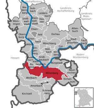
Miltenberg
| coat of arms | Germany map | |
|---|---|---|

|
Coordinates: 49 ° 42 ' N , 9 ° 16' E |
|
| Basic data | ||
| State : | Bavaria | |
| Administrative region : | Lower Franconia | |
| County : | Miltenberg | |
| Height : | 129 m above sea level NHN | |
| Area : | 60.18 km 2 | |
| Residents: | 9304 (Dec. 31, 2019) | |
| Population density : | 155 inhabitants per km 2 | |
| Postal code : | 63897 | |
| Area code : | 09371 | |
| License plate : | MIL, OBB | |
| Community key : | 09 6 76 139 | |
| City structure: | 8 districts | |
City administration address : |
Engelplatz 69 63897 Miltenberg |
|
| Website : | ||
| Mayor : | Bernd Kahlert ( CSU ) | |
| Location of the city of Miltenberg in the Miltenberg district | ||
  |
||

Miltenberg is the district town of the district of the same name in the administrative district of Lower Franconia and has been part of Bavaria since 1816 .
geography


Geographical location
The historic Miltenberg lies to the left of the Main on the left knee of the Mainviereck between Spessart and Odenwald . Since the bed of the Main is relatively close to the foot of the Odenwald in the Miltenberg area, only a narrow strip of usable area remains on the left-hand side of the Main, which has been repeatedly flooded by the Main floods over the past centuries. The old town , which is located there, suffered considerable damage from these floods . Since around the beginning of the 20th century, Miltenberg has also expanded on the right side of the Main after buying land from the neighboring community of Großheubach . The topographically highest point of the city is 482 m above sea level. NN at the summit of the mountain "Kohlplatte", south of Miltenberg, the lowest is in the Main at 120.5 m above sea level. NN .
The population of Miltenberg and the neighboring communities of Großheubach, Kleinheubach and Bürgstadt, which are directly adjacent to the city, amount to more than 22,000 inhabitants.
City structure
Eight districts belong to Miltenberg:
|
Surname
etymology
The city of Miltenberg takes its name from the Mildenburg above the town .
Earlier spellings
Earlier spellings of the place from various historical maps and documents:
- 1225 Miltinberg
- 1272 Miltenberg
- 1291 Mildemberg
- 1675 Miltenberg
history


Until the church is planted
Even the people of prehistory and early history knew about the strategic importance of the bottleneck at the Mainknie between Odenwald and Spessart and erected mighty ring walls on the Greinberg ( Greinberg ring wall ) above Miltenberg and on the Bürgstadter Berg ( ring wall Burgstadter Berg ). Around 159/160 AD, the Romans connected the “Vorderen Limes ”, which runs almost straight to the south, to the Main. In the vicinity of today's Miltenberg, the Limes met the Main, which from here further north represented the natural border between the Roman Empire and Germania . There are the remains of two Roman forts between Miltenberg and Kleinheubach ( Fort Miltenberg-Altstadt , ORL 38) and between Miltenberg and Bürgstadt ( Fort Miltenberg-Ost , ORL 38a).

With the Limes case by no later than 159/160 n. Chr. And the withdrawal of Roman troops lost the authorities responsible for border protection castles their function. The Miltenberg-Altstadt fort was still inhabited in the 4th century, which is evidenced by coin finds. No definite traces of settlement can be found for the 5th century. From the 7th century, possibly as early as the 6th century, the Roman ruins were inhabited again. In the eastern corner of the former fort, a mortar wall was built using the Roman wall. Finds of spores indicate high-ranking people and suggest that the fort was associated with the Frankish colonization in the east . In the following centuries the complex was hardly used until a residential tower was built in the east corner of the old fort in the 12th century. This could already have been the seat of the Wallhausen family, which is attested here shortly afterwards.
Under the protection of the Mildenburg (built around 1200), today's town of Miltenberg developed southeast of the Miltenberg-Altstadt fort. It was first mentioned in writing in 1237. From around 1379, the two city towers, the Mainz and Würzburger Tor, delimited today's old town, which grew narrow and elongated between the river and the mountainside, to the west and east. The Miltenberg red sandstone was already in great demand in the Middle Ages . Therefore, objects such as millstones or columns were carved in the surrounding forests . The St. Peter Hospital was founded by Archbishop Peter von Aspelt before 1319 . According to data from the Society for Leprosy "in front of the city" in Miltenberg, in today's Eichenbühler Strasse, there was a medieval leprosy , which however no longer existed in the middle of the 18th century.


Miltenberg belonged to Kurmainz until 1803 and was the seat of the Miltenberg office there . This is still evident today in the Mainz wheel in the city arms. After the Reichsdeputationshauptschluss Miltenberg came to the Principality of Leiningen , with which it was incorporated into the Grand Duchy of Baden in 1806. After the city belonged to the Grand Duchy of Hesse-Darmstadt from 1810 , it became Frankfurt a. M. Treaty concluded between Austria, Prussia and Hesse Darmstadt and, according to the agreement of July 7, 1816, part of the Kingdom of Bavaria . In the course of the administrative reforms in Bavaria, the municipal edict of 1818 created today's urban municipality.
Administrative history
In 1862 the Miltenberg District Office was formed, on whose administrative area Miltenberg was located. As everywhere in the German Reich , the term district was introduced in 1939. Miltenberg was now one of the 31 communities in the old district of Miltenberg . On July 1, 1972, this merged with the district of Obernburg am Main to form the new district of Miltenberg .
20th and 21st centuries
The hay columns , which were intended for the construction of the Mainz Cathedral , also come from Miltenberg . In the middle of the Mainzer Domplatz there is one of these hay pillars with a corresponding sign.
Miltenberg has a historic old town with numerous half-timbered houses .
On February 22, 1945, six American fighter-bombers attacked the city with bombs and on-board weapons. There were 20 dead. The Main Bridge was blown up on March 28, 1945 by retreating German troops. The gatehouse and pillars were preserved. On March 31, US troops moved into Miltenberg.
In 1912 and 1955, Miltenberg acquired land on the right side of the Main to expand the city. Mildenburg has been owned by the city of Miltenberg since 1979, the exterior parts were renovated in 1971, and a multi-year renovation and restoration was completed in 2011. Inside the castle there is now a museum with art collections from the Diocese of Würzburg . The Toutonenstein (now in the Municipal Museum), a five-meter-high sandstone column, whose inscription remains a mystery to this day with regard to its meaning , used to stand in the castle courtyard .
In 2008 the 3rd Franconian Day took place in Miltenberg as part of the Lower Franconian Culture Days .
Incorporations
On January 1, 1971, the previously independent municipality Breitendiel was incorporated. On January 1, 1976, Mainbullau , Schippach (with Berndiel) and Wenschdorf (with Monbrunn ) were added.
Religions
In 1987 around three quarters (74.7% = 6,602 people) of Miltenberg's residents were Roman Catholics (census May 25). In 2011 this value had fallen to 58.1% (5,282 people) (census May 9). At the same time, the proportion of the Evangelical Lutheran population rose slightly from 16.3% (1,440 people) to 16.6% (1,509 people). The remainder belonged to a different or no denomination.
- Catholic pastor of the city (since 1985)
- 1985–1998: Benno von Bundschuh
- 2000–2008: Ulrich Boom
- 2009–2010: Robert Stolzenberger
- 2010–2014: Christian Lutz
- 2015–2016: Hermann Steinert (†)
- since 2017: Jan Kölbel
politics
City council
The 2020 city council election resulted in the following result:

Mayor of the city
|
|
Town twinning
There is since June 1982 twinning with Arnouville in France. Since November 16, 2004 there has been a town partnership with Dux in Bohemia .
Sponsorship
In 1960 the sponsorship for the expelled Sudeten Germans from the city and district of Dux was taken over, which in 2004 led to the city partnership.
Culture and sights
Attractions
- Mildenburg
- Historical old city
- "Schnatterloch" on the historic market square
- Hotel Zum Riesen (one of the oldest or possibly the oldest inn in Germany)
- Old Town Hall
- Wurzburg Gate
- Mainz Gate
- City parish church of St. James
- Franciscan Church
- Johanneskirche (1895–1897, architect Ludwig Hofmann)
- Laurentiuskapelle with the adjoining Laurentiusfriedhof (approx. 14th century).
Miltenberg is on the Franconian red wine hiking trail , which was laid out in 1990 and leads from Großwallstadt am Main via Miltenberg to Bürgstadt.
A new concept was opened with the Route of Industrial Culture Rhine-Main . It combines industrial buildings on the 160 kilometers between Miltenberg and Bingen am Rhein to create an adventure route through the industrial age in southern Germany. 700 buildings have already been scientifically recorded, for example the old Miltenberg main station .

Hotel "Zum Riesen"

City parish church of St. James
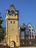
The Würzburger Tor east of the city center
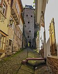
Schnatterlochtor
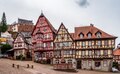
Miltenberg market square

Miltenberg main street

St. Laurentius cemetery chapel


Museums
Regular events
- On the first weekend in July, the "Mainfest" takes place every two years, replacing the traditional (old) city festival.
- The “Mildenburg Theater Days” take place at the end of July.
- From the last weekend in August to the first weekend in September, the Michaelismesse , the largest folk festival in the Bavarian Lower Main, takes place for ten days .
- The “Miltenberger Weinherbst” takes place from the end of September to the beginning of October.
- The Christmas market is open on the four weekends in Advent (Friday to Sunday) .

Economy and Infrastructure
Most important is tourism, which brings numerous visitors from the Hessian conurbations ( Hanau , Offenbach am Main , Darmstadt , Frankfurt am Main ) to Miltenberg, especially on weekends , as well as red sandstone and trade.
In the Future Atlas 2016 , the Miltenberg district was ranked 197th out of 402 districts, municipal associations and independent cities in Germany, making it one of the regions with a “balanced risk-opportunity mix” for the future.
traffic

Miltenberg is the junction of the Aschaffenburg – Miltenberg , Miltenberg West – Wertheim and Seckach – Miltenberg railway lines . There are half-hourly connections to Aschaffenburg during the day. 1977 put German Federal Railways the suburban railway terminus ( Miltenberg Hauptbahnhof still) and replaced him with the north of the Main located from existing breakpoint to the station Miltenberg upgraded through station . Another stop is in the Breitendiel district.
Miltenberg is connected to the Hessian metropolitan areas, where many residents find work. A road bridge has spanned the Main since 1900 and connects the old town with Miltenberg Nord. In 2008 the bypass, which has been discussed and planned for over 25 years, was completed. This includes a second road bridge over the Main. The financing of the construction project in the amount of 55 million euros took place for the first time in Bavaria via the so-called public private partnership model.
In the Mainbullau district, about three kilometers away, there is a traffic and sports airport .
The federal road 469 and the state roads 2309 and 2310 run through the urban area of Miltenberg .
Bike trails
The following cycle paths lead through the urban area .
Along the Mud , through the Breitendiel district:
- The 225 km long 3-country cycle route leads as a circular route through the triangle of Hesse, Baden-Württemberg and Bavaria. The route explores the Odenwald along the Mümling, Neckar and Main rivers.
- The German Limes Cycle Route leads from Bad Hönningen through Westerwald , Taunus and Odenwald to Regensburg, 818 kilometers away, and is based on the historical course of the Upper German-Raetian Limes .
Along the Main:
- The Main Cycle Path leads from the two sources of the Main along the river to its confluence with the Rhine near Mainz . It has a total length of about 600 kilometers.
- The Main-Tauber-Franconian wheel eight
- The D-Route D5 (Saar-Mosel-Main) . It leads over 1021 kilometers from Saarbrücken via Trier, Koblenz, Mainz, Frankfurt am Main, Würzburg and Bayreuth to the Czech border.
Hiking trails
The approximately 180 km long Jakobsweg Main-Taubertal begins in Miltenberg. The Nibelungensteig , a 130-kilometer long long- distance hiking trail certified with the quality seal “Quality Trail Wanderable Germany”, runs through the Schnatterloch, the old town and along the Main . The 794 km long Franconian Marienweg also leads through Miltenberg. The Limes hiking trail of the Swabian Alb Association , a section of the German Limes hiking trail , begins in Miltenberg. As far as Osterburken , this path is managed by the Odenwald Club as the Eastern Limes Path .
schools
Different types of schools are represented in Miltenberg:
- Miltenberg-Obernburg vocational school
- Miltenberg primary school
- Middle School Miltenberg
- Heinrich Ernst Stötzner School (support center )
- Johannes-Butzbach- Gymnasium
- Johannes-Hartung- Realschule
Breweries
Today there is a brewery in the city, namely the Faust brewery . Another brewery, the Kalt-Loch-Bräu , existed until the end of March 2010.
Paper mill
The manufacturing industry includes u. a. the Fripa hygiene paper factory , a manufacturer of toilet paper and paper tissues . Part of the waste heat generated during paper production is fed into a specially built local heating network and supplies the Johannes-Butzbach-Gymnasium, the Johannes-Hartung-Realschule and the H.-E.-Stötzner-School. For this environmentally friendly heat supply, the Miltenberg and Fripa districts received the 2018 Climate Protection Prize awarded by the Nature Conservation Federation .
energy
The headquarters of EMB Energieversorgung Miltenberg-Bürgstadt GmbH & Co. KG, in which the city of Miltenberg and Markt Bürgstadt are involved, is located in Miltenberg. The EMB is responsible for the power supply in Miltenberg with the district Breitendiel and the market town of Bürgstadt. In addition, it is also responsible for the water supply of the city of Miltenberg with the districts Breitendiel and Mainbullau, as well as the market town of Bürgstadt.
Personalities
Honorary citizen
sons and daughters of the town
- Johannes Butzbach (1477–1516), humanist
- Johannes Hartung (1505–1579), Graecist and Hebrew
- Christoph Wamser (1575–1649), baroque architect
- Nikolaus Blöchinger (born June 29, 1659 - † September 17, 1715 in Seligenstadt ), Abbot Franziscus II.
- Joseph Martin Kraus (1756–1792), composer
- Joseph Anton Helfrich (1762–1837), cathedral chapter, diplomat at the Congress of Vienna
- Franz Ambros Alexander, founder of the musical instrument factory Gebr. Alexander Mainz
- Gottlieb Leo (1786–1837), lawyer, mayor of Aschaffenburg
- Philipp Wirth (1808–1878), painter
- Carl Gerster (1813–1892), doctor and founder of the Franconian Choir Association
- August Krug (1815–1856), German-American entrepreneur and brewer
- Joseph Georg von Ehrler (1833–1905), Bishop of Speyer
- Hermann Graml (1928–2019), historian and publicist
- Bernhard Oswald (* 1930), entrepreneur
- Norbert Walter (1944–2012), economist, chief economist at Deutsche Bank AG
- Joachim Maier (* 1945), Roman Catholic theologian
- Ernst Volland (* 1946), artist
- Thomas Huther (* 1956), photographer, artist and graphic designer
- Heiko Michael Hartmann (* 1957), lawyer and writer
- Maria Bachmann (* 1964), actress, screenwriter and director
- Bodo Kuhn (* 1967), athlete
- Bernd Roos (* 1967), handball player
- Vince Ebert (* 1968), cabaret artist, comedian and physicist
- Philipp Weber (* 1974), cabaret artist
- Björn Hertl (* 1976), soccer player
- Heiko Grimm (* 1977), handball player
- Eva-Maria Grein von Friedl (* 1980), actress and musical artist
- Isabell Polak (* 1981), actress
- Andreas Kunz (* 1982), handball player
- Dominik Klein (* 1983), handball player at THW Kiel and world champion 2007
- Philipp Grimm (* 1985), handball player
- Sebastian Heidinger (* 1986), soccer player at Wacker Nordhausen II
Personalities associated with the city
- Matthias von Buchegg (? –1328), Archbishop of Mainz and Imperial Chancellor of the Holy Roman Empire of the German Nation
- Johann Draconites also Johannes Drach or Trach (e) (≈1494–1566), theologian and reformer; 1522–23 pastor in Miltenberg
- The Juncker family of sculptors (late 16th to late 17th century)
- Johann Martin Schmidt (1700–1763), Baroque and Rococo builder
- Johann Robert von Capitain (1824–1881), emperor. Turkish major, owner of the "White Castle" on the Grauberg
- Wilhelm Conrady (1829–1903), Roman provincial archaeologist
- Rudolf Hirth du Frênes (1846–1916), painter
- Ludwig Hofmann (1862–1933), architect of the Protestant church 1895–1897, the Protestant school around 1900, the synagogue 1903–1904 and the villa of the Commerce Councilor Gustav Jacob
- Jakob Fischer-Rhein (1888–1976), painter
- Petrus Karl Mangold (1889–1942), Franciscan, 1920–31 pastor and people's missionary in Miltenberg Monastery
- Werner Beierwaltes (1931–2019), philosophy professor
- Anton Schlembach (1932–2020), Bishop of Speyer
- Ulrich Boom (* 1947), since December 6, 2008 auxiliary bishop in Würzburg (2000–2008 pastor in St. Jakobus, Miltenberg)
Oddities
In addition to the well-known old fountain at the “Schnatterloch” (as the market square is also known colloquially) there is also the “Staffelbrunnen”, to which a few steps lead down. The Miltenbergers used this flowing water in the past and were therefore called “Staffelbrünnler” in a very urban and elegant way. But the vernacular called them "Staffelbrunser"; however with s and not with z.
Lilli Chapeau and Clemens Bauer run the smallest professionally run theater in the world in Miltenberg (without employees). It measures 20 m² and offers the public 27 seats.
In 2006 a demonstration of an NPD youth organization took place in Miltenberg on the market square in the immediate vicinity of the Catholic parish church of St. Jakobus . The then pastor Ulrich Boom let the church bells ring for 20 minutes in protest. The second hardest bell in the diocese of Würzburg was so loud that the rally had to be abandoned after a short time. The campaign, for which Boom was awarded the Aschaffenburg Courage Prize , gained national media attention.
Miltenberg as a film set
Several feature films were shot in Miltenberg. In 1934 a number of exterior shots were taken for the Gottfried Keller film Regine . In the 1954 by Wolfgang Schleif staged home movie Cute Little Anny u. a. to see the marketplace. The house at Hauptstrasse 185 served as the “Gasthaus zum golden Anker”. The opening sequences of Das Wirtshaus im Spessart and Das Spukschloss im Spessart were also created on the market square. In the latter, the old bridge over the Mud with the Laurentius Chapel could also be seen.

literature
- Bernhard Oswald (ed.): Paths of life. Miltenberg high school graduates 1950 , Miltenberg 2007, ISBN 978-3-00-020445-6
- Bernhard Oswald: The Limes Fort Miltenberg-Altstadt ISBN 978-3-937996-18-9 .
- Werner Reuling: Miltenberg in the old days. The city and its history on old postcards. M. Metzger, Miltenberg 2001. ISBN 3-00-008208-5 .
- Jakob Josef Schirmer: Chronicle of the City of Miltenberg , Miltenberg 2004, ISBN 3-00-013149-3
- 750 years of the city of Miltenberg 1237–1987. Contributions to the history, economy and culture of a Franconian city , Miltenberg 1987. DNB 871122626 , DNB 210751924
- Rudolf Vierengel: Miltenberg am Main. A cultural and art historical guide through the old town on the Main with reflections on Großheubach, Engelberg Abbey, Kleinheubach and Bürgstadt. 4th, expanded and supplemented edition, Amorbach 1985
- Michael Josef Wirth: Chronicle of the city of Miltenberg , Miltenberg 1890; Reprint: Neustadt / Aisch 1987, ISBN 3-923006-58-6
- Wilhelm Otto Keller: 775 years of the city of Miltenberg 1237–2012. Contributions to the city history by Wilhelm Otto Keller, Miltenberg 2012, ISBN 978-3-87707-864-8
Web links
- City of Miltenberg
- Franconian hay pillars
- Miltenberg City Museum
- Former Jewish community in Miltenberg Jewish cemeteries
- Industrial culture in the Miltenberg district ( Memento from December 3, 2008 in the Internet Archive ) in the Internet Archive
- Entry on the coat of arms of Miltenberg in the database of the House of Bavarian History
- Miltenberg: Official statistics of the LfStat
- Pictures, videos and texts from Miltenberg
- Miltenberg on legendhafter-odenwald.de
- Virtual 360 ° tour through Miltenberg's old town
Individual evidence
- ↑ "Data 2" sheet, Statistical Report A1200C 202041 Population of the municipalities, districts and administrative districts 1st quarter 2020 (population based on the 2011 census) ( help ).
- ^ Kohlplatte in BayernAtlas - the map viewer of the Free State of Bavaria. Retrieved August 14, 2020 .
- ^ Stadt Miltenberg in the local database of the Bavarian State Library Online . Bayerische Staatsbibliothek, accessed on September 1, 2019.
- ↑ a b Wolf-Armin von Reitzenstein : Lexicon of Franconian place names. Origin and meaning . Upper Franconia, Middle Franconia, Lower Franconia. CH Beck, Munich 2009, ISBN 978-3-406-59131-0 , p. 148 ( limited preview in Google Book search).
- ↑ Claus-Michael Hüssen: The Roman settlement in the area around Heilbronn. Theiss, Stuttgart 2000, ISBN 3-8062-1493-X , p. 145.
- ^ Bernhard Albert Greiner: The contribution of the dendrodata from Rainau book to the Limesdatierung. In: Limes XX. Estudios sobre la frontera Romana. Ediciones Polifemo, Madrid 2009, ISBN 978-84-96813-25-0 , p. 1289.
- ↑ Bernd Becker: Felling dates of Roman construction timbers based on a 2350 year old South German oak tree ring chronology . In find reports from Baden Württemberg . Volume 6, Theiss, Stuttgart 1981, ISBN 3-8062-1252-X , p. 386.
- ^ Dieter Planck, Willi Beck: The Limes in Southwest Germany . 2nd edition, Theiss, Stuttgart 1987, ISBN 3-8062-0496-9 , p. 82 u. Fig. 84.
- ^ Norbert Goßler (2006): On the reuse of Roman military installations in the Middle Ages: Some examples from the Upper Germanic-Rhaetian Limes. In: Continuity issues. Middle Imperial Era - Late Antiquity - Early Middle Ages . Pp. 31-44.
- ↑ Medieval Leprosoria in Today's Bavaria, Society for Leprosy, Münster 1995, accessed January 6, 2017 ( Memento of the original from February 6, 2015 in the Internet Archive ) Info: The archive link was automatically inserted and not yet checked. Please check the original and archive link according to the instructions and then remove this notice.
- ^ Wilhelm Volkert (ed.): Handbook of Bavarian offices, communities and courts 1799–1980 . CH Beck, Munich 1983, ISBN 3-406-09669-7 , p. 523 .
- ^ Federal Statistical Office (ed.): Historical municipality directory for the Federal Republic of Germany. Name, border and key number changes for municipalities, counties and administrative districts from May 27, 1970 to December 31, 1982 . W. Kohlhammer GmbH, Stuttgart / Mainz 1983, ISBN 3-17-003263-1 , p. 751 .
- ↑ Statistics communal - Miltenberg , accessed on June 14, 2020
- ↑ https://www.wahlen-in-mil.de/wahlverbindungen/kommunalwahlen_2020/09676139/html5/Gemeinderatswahl_Bayern_74_Gemeinde_Stadt_Miltenberg.html
- ↑ New ways to the old industrial culture (no longer online). FR from Nov. 27, 2006
- ↑ Museums of the City of Miltenberg - home page. Retrieved July 22, 2019 .
- ↑ Odenwälder Kartoffelsupp, October 2019, p. 17.
- ↑ Zukunftsatlas 2016. Archived from the original ; accessed on March 23, 2018 .
- ↑ Timetable 781 Maintalbahn - valid from March 2, 2020 accessed on June 13, 2020
- ↑ Jakobsweg Main-Taubertal (pilgrimage route) - wanderkompass.de. In: wanderkompass.de. Retrieved August 3, 2020 .
- ↑ Main-Echo / Bote vom Untermain: Brewery Eder takes over the Kalt-Loch brand
- ↑ District Miltenberg receives climate protection award for local heating network ( page no longer available , search in web archives ) Info: The link was automatically marked as defective. Please check the link according to the instructions and then remove this notice. . In: Primavera , December 4, 2018. Retrieved December 6, 2018.
- ↑ Abbot Franziscus II. - Contact to greats of the world on op-online.de
- ↑ Werner Trost Stampes, Worzelköpp and Staffelbrunzer Landkreis Miltenberg 2003
- ↑ http://www.lilli-chapeau.de/das-kleine-theater-in-miltenberg/
- ↑ The power of church bells . FAZ, December 9, 2008

Altenbuch | Amorbach | Bürgstadt | Collenberg | Dorfprozelten | Eichenbühl | Elsenfeld | Erlenbach am Main | Eschau | Faulbach | Großheubach | Großwallstadt | Hausen | Kirchzell | Kleinheubach | Kleinwallstadt | Klingenberg am Main | Laudenbach | Leidersbach | Miltenberg | Mömlingen | Mönchberg | Neunkirchen | Niedernberg | Obernburg am Main | Röllbach | Rüdenau | Schneeberg | Stadtprozelten | Sulzbach am Main | Weilbach | Wörth a.Main
Unregulated areas: forest forest | High maintenance