Waag (Hückeswagen)
|
Scales
City of Hückeswagen
Coordinates: 51 ° 8 ′ 54 ″ N , 7 ° 19 ′ 39 ″ E
|
||
|---|---|---|
| Height : | 310 m above sea level NN | |
| Postal code : | 42499 | |
| Area code : | 02192 | |
|
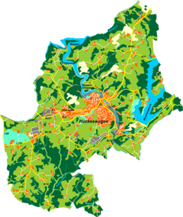
Location of Waag in Hückeswagen |
||
Waag , which was also Oberwaag until the 19th century , is a former court and today's location in Hückeswagen in the Oberbergisches Kreis in the administrative district of Cologne in North Rhine-Westphalia (Germany).
Location and transport links
Waag is located west of the city center of Hückeswagen in the larger district of Wiehagen at the intersection of Wiehagener Strasse with the streets Erlensterz (qualified as K1 district road) and August-Lüttgenau-Strasse . The location that originally consisted of the four residential areas Oberwaag , Hartloffswaag , Trostwaag and Tillmannswaag has now largely merged into the closed residential development along the above-mentioned streets, which is accessed here through the residential street Am Waag . One of the residential areas in Waager is still standing apart from the buildings today.
Other neighboring towns are the Hückeswagen core city, Pixwaag , Erlensterz , Brunsbach , Wiehagerhöhe , Raspenhaus and the Schnabelsmühle .
history
In 1532 the place was mentioned for the first time in a list of Hückeswagen residents. The spelling of the first mention was to the scales . However, the origin can be dated to before the year 1297, since (Ober-) Waag as a split from Pixwaag (Niederwaag) was curmed up into the 19th century , but after 1297 no courtyards in Hückeswagen were required to have a curvature. The Topographia Ducatus Montani map from 1715 shows the farm as a scales . In the 18th century the place belonged to the Bergisches Amt Bornefeld-Hückeswagen . According to the waiter's bill of 1757/1766, the Oberwaag farm was only 22 acres and 44 rods in size.
Around 1767 Oberwaag belonged to the cloth manufacturer Johann Wilhelm Bockhacker , who until 1790 is known as the "head" and "elder" of the parish. Waag was also called Bockhacker's Waag after him . In the 18th century the place belonged to the Bergisches Amt Bornefeld-Hückeswagen . In 1815/16 36 people lived in the village. In 1828 the owners Johann Jungfernbroich , Christian Hartloff and JP Troost finally replaced Kurmut. Shortly afterwards (Ober-) Waag split up into the residential areas Hartloffswaag (from 1809), Trostwaag (from 1810), Oberwaag (from 1845) and Tillmannswaag (from 1859 through sale from a Gottfried Tillmann ).
In 1832 Waag belonged to the Berghauser Honschaft , which was part of the Hückeswagen external citizenship within the Hückeswagen mayor . The place, categorized as a hamlet according to the statistics and topography of the administrative district of Düsseldorf , had five houses and one agricultural building at that time. At that time 54 people lived in the place, 17 Catholic and 37 Protestant faith.
In Hartloffswaag there was a thatched-roof house from around 1650 until May 1949, which was demolished for reasons of disrepair. Troostwagg was 123 rods tall. The son of Johann Peter Troost , Peter Troost , ran a brewery in his house around 1864 , in which beer was brewed according to the Bavarian brewing method. The Oberwaag estate was 278 acres and extended into the Erlensterz forest area, but was parceled out around 1830 and the land was sold to surrounding residential areas. Tillmannswaag was one of the largest goods Hückeswagens until the first third of the 20th century and in 1928 still covered 29 hectares (= 116 Prussian acres).
In the municipality lexicon for the Rhineland province , six houses with 88 inhabitants are given for 1885. At that time the place belonged to the rural community Neuhückeswagen within the Lennep district . In 1895 the place had six houses with 72 inhabitants, in 1905 five houses and 73 inhabitants.
literature
Wilhelm Blankertz: Tewaag, its name, its farm and its history ( online )
Individual evidence
- ^ Johann Georg von Viebahn : Statistics and topography of the administrative district of Düsseldorf. Part 2: Containing the statistical table of places and distances and the alphabetical index of place names. Schreiner, Düsseldorf 1836, p. 13 .
- ^ Royal Statistical Bureau (Prussia) (Ed.): Community encyclopedia for the Rhineland province. Based on the materials from the census of December 1, 1885 and other official sources (= community encyclopedia for the Kingdom of Prussia. Vol. 12, ZDB -ID 1046036-6 ). Publishing house of the Royal Statistical Bureau, Berlin 1888.
- ^ Royal Statistical Bureau (Prussia) (Ed.): Community encyclopedia for the Rhineland province. Based on the materials from the census of December 1, 1895 and other official sources (= community encyclopedia for the Kingdom of Prussia. Vol. 12). Publishing house of the Royal Statistical Bureau, Berlin 1897.
- ^ Royal Statistical Bureau (Prussia) (Ed.): Community encyclopedia for the Rhineland province. Based on the materials from the census of December 1, 1905 and other official sources (= community encyclopedia for the Kingdom of Prussia. Vol. 12). Publishing house of the Royal Statistical Bureau, Berlin 1909.

