Altmuehl
| Altmuehl | ||
|
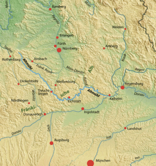
Location of the Altmühl between Main and Danube |
||
| Data | ||
| Water code | EN : 138 | |
| location | Bavaria , Germany | |
| River system | Danube | |
| Drain over | Danube → Black Sea | |
| source |
Burgbernheim , about 11 km northeast of Rothenburg ob der Tauber 49 ° 25 ′ 50 ″ N , 10 ° 18 ′ 20 ″ E |
|
| Source height | approx. 460 m above sea level NHN | |
| muzzle | below Kelheim in the Danube Coordinates: 48 ° 54 '36 " N , 11 ° 54' 21" E 48 ° 54 '36 " N , 11 ° 54' 21" E |
|
| Mouth height | approx. 339 m above sea level NHN confluence with the Danube |
|
| Height difference | approx. 121 m | |
| Bottom slope | approx. 0.53 ‰ | |
| length | 226.9 km to the Danube |
|
| Catchment area | 3,258.36 km² | |
| Discharge at the Beilngries gauge above the Sulz A Eo : 2266 km² Location: 42.3 km above the mouth |
NNQ (09/01/1998) MNQ 1985–2012 MQ 1985–2012 Mq 1985–2012 MHQ 1985–2012 HHQ (03/19/1988) |
4.29 m³ / s 6.33 m³ / s 17 m³ / s 7.5 l / (s km²) 86.2 m³ / s 159 m³ / s |
| Discharge at the mouth A Eo : 3258 km² |
MQ 1985–2012 Mq 1985–2012 |
24.3 m³ / s 7.5 l / (s km²) |
| Reservoirs flowed through | Altmuehlsee | |
| Small towns | Gunzenhausen , Treuchtlingen , Eichstätt , Kelheim | |
| Navigable | 34 km (from Dietfurt an der Altmühl to Kelheim , as part of the Main-Danube Canal ) |
|
|
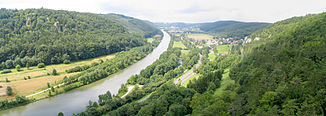
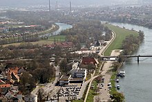
Altmühl below Riedenburg , here a section of the Main-Danube Canal |
||
The Altmühl is a 227 km long river in Bavaria , which flows into the Danube from the left with an average water flow of a good 24 m³ / s after an initially south-east and then east-facing course near Kelheim . Its last 34 km from Dietfurt it flows in the bed of the Main-Danube Canal .
Origin of name
The origin of the river name is interpreted differently. According to one opinion, the name Altmühl is a folk etymological Germanization of an older water body name, which has been handed down since the 8th century in the forms Alcmona , Alchmona and Alcmana . The meaning of these Celtic and Indo-European names is water that flows into a mountain range to be protected . Another interpretation of the name also takes on a Celtic origin, which derives from the Celtic alk (= very) and the Celtic moin or mun (= gentle, calm, quiet); thereafter the motif of the naming would be that the Altmühl is a very calm, quiet, gentle river. According to yet another view, the river is named after a Nahanarval deity Alcy or - as with the Main - a primitive Germanic word Modina was used as the godfather of the river name.
Catchment area and river course
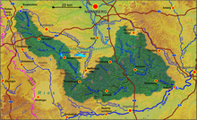
The 3258 km² catchment area of the Altmühl includes the southern part of the Franconian Alb as well as a narrow strip of the Franconian Keuper-Lias-Land upstream of the Franconian Alb in the northwest up to the break of the Frankenhöhe to the Windsheimer Bucht . The highest point of the catchment area is the 656 m high Dürrenberg approx. 11 km south of Gunzenhausen .
The Altmühl rises on the southern slope of the Franconian ridge northeast of Rothenburg ob der Tauber , near the Hohen Leite and about 500 m southeast of the Burgbernheimer Einöde Wildbad . In 1904 , the Royal Bavarian Hydrotechnical Bureau in Munich established the drainage ditch of the Hornauer Weiher as its source . This is fed by several streams; in the meantime the source of one of them is considered to be the old mill origin. The Altmühl rises just south of the great European watershed and then flows mainly in a south-easterly direction. It is the river with the lowest gradient in Bavaria, flows very slowly and is even one of the slowest German rivers. The Altmühl is also the longest river that runs exclusively within a German federal state.
The Altmühl can be divided into three parts.
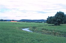
In the upper third it is a slowly flowing meadow river in a wide valley. The landscape is flat, slightly hilly and the ground consists mainly of rocks from the Keuper period , here mainly limestone and clay stones. The mudstone seals the subsoil, which is why the Altmühl in the upper reaches is not a very wide stream.
In its middle course, the Altmühl flows past the Altmühlsee near Gunzenhausen in the north and east . The river bed was recreated here when the Altmühlsee was built in the 1980s. On the south bank of the Altmühlsee the river crosses the Altmühlüberleiter underground .
Only during floods does water get from the Altmühl via the Altmühl feeder to the Altmühlsee, which is a reservoir for the Danube-Main crossing . This lake is designated as a bird and nature reserve. The water taken from the lake flows through the tunnel of the Altmühlüberleiters first into the Kleine Brombachsee and thus into the Regnitz river system north of the continental watershed . The Regnitz water ultimately flows over the Main into the Rhine , so that an artificial river bifurcation was created with the transition .
From Treuchtlingen the Altmühl flows in its lower reaches through the Franconian Jura plateau , in whose karstende limestone it has dug a narrow valley. There are sometimes bizarre rock formations on the steep valley slopes. Cauldron-shaped washouts located around 20 m above the river level can be seen particularly well in the village of Eßlingen .

From Dollnstein on , the Jura breakthrough valley suddenly becomes much wider. From here the Altmühl flows through a former valley of the greater Danube . At Rennertshofen this "Urdonautal" branches off from today's Danube valley; in the section where the Altmühl does not yet flow in it, but only small streams, it is called the Wellheimer dry valley .
From 1910 the course of the river from Unterwurmbach downwards was straightened and regulated with numerous weir systems , which cut off many oxbow lakes . In the meantime, some of the regulatory measures have been reversed, such as in the Treuchtlinger district of Graben and shortly before Eichstätt near Wasserzell .
Its lowest course from Dietfurt an der Altmühl was expanded in the middle of the 19th century with 10 barrages to become part of the Ludwig-Danube-Main Canal . The same route was used from 1975 to 1991 for the construction of the Main-Danube Canal , a large shipping route with barrages in Riedenburg and Kelheim . For the first time in a waterway construction project in Europe, landscape conservation plans were drawn up for ecological measures in order to create a substitute for interventions in nature and the landscape; 15% of the sewer construction costs were used for this. The Altmühl flows below Kelheim into the Danube at Danube kilometer 2411.54. The 34-kilometer Altmühl route is included in the Main-Danube Canal federal waterway ; in addition, there are 580 meters of Altmühl from above the Dietfurt weir to the MDK federal waterway.
The well-marked and well-established Altmühltal cycle path runs along the Altmühl . Canoeing is safe on the river itself.
Flow rate
At the mouth, the Altmühl has an average discharge of 24.3 cubic meters of water per second; in winter it is around 34 m³ / s and in summer around 16 m³ / s.
Flood
The Altmühl floods most frequently in late winter. High water marks on buildings in larger places along the Altmühl document significant floods of earlier times. Since the construction of the Altmühlsee near Gunzenhausen, the risk of flooding has decreased significantly because this dam catches the flood of the upper Altmühl and slowly releases it over the Regnitz to the water-poorer main area over the course of the year.

tourism
The Altmühl is a popular boat hiking river . Because of their cleanliness and their slow flow rate, there are several river swimming pools in their course , for example at Leutershausen and Ornbau .
Tributaries
- Wieseth (right, Ornbau)
- Gailach (right, Mörnsheim)
- Schwarzach (left, Kinding)
- Sulz (left, Beilngries)
- White Laber (left, Dietfurt an der Altmühl)
Cities, towns and places on the river
The areas of the following cities and municipalities are flowed through or touched by the Altmühl. They also mention all districts - including the main towns, if applicable - which are on the river or that the community is only local residents without any town on the run. The order is after the first entry or first contact with the municipality and within the municipalities strictly downstream. Since the Altmühl is sometimes also the municipality boundary and also enters the same municipality several times, the first districts of the following municipalities can sometimes be located on the water before the last of the previous one. A more detailed overview is provided by the BayernAtlas map below at the → web links .
-
Neustadt an der Aisch-Bad Windsheim district
- Burgbernheim (no places on the Altmühl)
-
Ansbach district
- Windelsbach with the districts of Hornau and Burghausen
- Colmberg with the districts of Binzwangen , Oberfelden , Unterfelden , Bieg and Meuchlein
- Leutershausen with the districts of Frommetsfelden , Höchstetten , Pfetzendorf , Zweiflingen , Erndorf , Jochsberg , Wolfsmühle , the city of Leutershausen, the districts of Saxony , Görchsheim , Rauenbuch and Weißenmühle
- Aurach (no places on the Altmühl)
- Herrieden with the districts of Niederdombach , Neunstetten (with the Altmühle), Mühlbruck , the city of Herrieden and the districts of Stegbruck , Winn and Menschenbuch
- Bechhofen with the districts of Thann , Weidendorf , Großenried and Kleinried
- Burgoberbach (no places on the Altmühl)
- Ornbau with the districts of Haag , Oberndorf , the town of Ornbau (with the town mill on the other side) and Gern
-
Weissenburg-Gunzenhausen district
- Muhr am See with the capital Muhr
- Gunzenhausen with the districts Schlungenhof , the city of Gunzenhausen, Aha and Unterasbach
- Dittenheim with the districts of Windsfeld and Ehlheim
- Theilenhofen with the district Gundelsheim an der Altmühl
- Meinheim (no places on the Altmühl)
- Alesheim with the districts Fischerhaus , Trommetsheim and Lengenfeld
- Market Berolzheim (no places on the Altmühl)
- Treuchtlingen with the districts Bubenheim , Zollmühle , Graben , Gstadt , the city of Treuchtlingen and the districts Kästleinsmühle and Dietfurt
- Pappenheim with the town of Pappenheim and the district ofzimmer
- Solnhofen with the main town Solnhofen and the district Eßlingen
-
District of Eichstätt
- Mörnsheim with the districts Altendorf and Hammermühle
- Dollnstein with the districts of Hagenacker , Eisenhammer , Dollnstein, Bubenrothermühle , Breitenfurt , Attenbrunnmühle and Obereichstätt
- Eichstätt with the districts of Wasserzell , Rebdorf , Marienstein , Eichstätt, Pietenfeld an der Leithen and Landershofen
- Walting with the districts Pfünz , Almosmühle , Inching , Brunnmühle , Walting, Rieshofen , Pfalzpaint and Gungolding
- Kipfenberg with the districts Arnsberg , Regelmannsbrunn , Böhming , Kipfenberg, Grösdorf and Kemathen
- Kinding with the districts of Ilbling , Kinding, Unteremmendorf , Kratzmühle and Kirchanhausen
- Beilngries with the districts of Beilngries, Leising , Kottingwörth and Kottingwörthermühle
-
District of Neumarkt in the Upper Palatinate
- Dietfurt an der Altmühl with the districts of Grögling , Töging , Griesstetten , Dietfurt and Einsiedel
-
District of Kelheim
- Riedenburg with the districts of Meihern , Deising , Untereggersberg , Oberhofen , Gundlfing , Haidhof , Riedenburg, Prunn , Nusshausen , Einthal and Pillhausen (Kastlhof)
- Essing with the districts Weihermühle , Neuessing , Heidenstein , Altessing , Unterau and Oberau
- Kelheim with the districts of Gronsdorf , Kelheim and Kelheimwinzer
See also
literature
- Johann Kaspar Bundschuh : Altmühl . In: Geographical Statistical-Topographical Lexicon of Franconia . tape 1 : A-egg . Verlag der Stettinische Buchhandlung, Ulm 1799, DNB 790364298 , OCLC 833753073 , Sp. 60-63 ( digitized version ).
- Peter Miotk, Harald Braun, Johann Schrenk: Panorama Altmühltal, A journey through pictures along the Panorama Trail Altmühltal from Gunzenhausen to Kelheim. Gunzenhausen 2010, ISBN 978-3-924270-65-0 .
- Johann Schrenk, Altmühltal and Franconian Lake District, Michael-Müller-Verlag Erlangen, 8th edition 2010, ISBN 978-3-89953-532-7 .
- Bernd Kunz: The Altmühl from the source to the mouth. Swiridoff Verlag Künzelsau 2005, ISBN 3-89929-047-X .
- The valley of the ancient mill. Tümmels, Nuremberg, ISBN 3-921590-98-1 .
- The ancient Danube valley of the Altmühl. Aerial photo tape. 132 pages, Tümmels, Nuremberg ( ISBN 3-921590-88-4 )
- The Altmühl Nature Park from the air. Schwarze Laber Foundation, Parsberg 2018, ISBN 978-3982026107 .
- Cycling map Altmühltal-Radweg , Publicpress-Verlag, ISBN 978-3-89920-200-7 .
- Bikeline bike tour book Altmühl-Radweg , Esterbauer, ISBN 3-850000-001 .
- M. Eckoldt (Ed.), Rivers and Canals, The History of German Waterways, DSV-Verlag 1998.
Individual evidence
- ↑ Height according to the contour map on the BayernAtlas (see also section → Weblinks )
- ↑ Height of the confluence with the Danube linearly interpolated according to two figures in blue in the middle of the Danube on the BayernAtlas, at Kelheim-Klösterl above and at Bad Abbach -Alkofen below.
- ↑ The water level of the Main-Danube Canal near Dietfurt an der Altmühl.
- ↑ a b c d Directory of stream and river areas in Bavaria - Lech to Naab river area, page 98 of the Bavarian State Office for the Environment, as of 2016 (PDF; 2.9 MB) (and following pages)
- ↑ Flood news service of the Bavarian State Office for the Environment ( information )
- ↑ a b Level value Beilngries above the Sulz (MQ: 17.0 m³ / s) increased by the runoff of the catchment area remaining below (992 km²). It is derived from the area discharge (Mq: 7.32 l / s.km²) of the similarly structured catchment area of the neighboring gauge Deuerling ( Schwarze Laber ) and results in an MQ of 7.3 m³ / s to be added for the Altmühl. (An extrapolation from the data from Beilngries above the Sulz would result in an increase of 7.45 m³ / s.)
- ↑ Google Earth
- ↑ Hans Krahe : Our oldest river names , Wiesbaden 1964, p. 106.
- ^ Wolf-Armin von Reitzenstein : Lexicon of Franconian place names. Origin and meaning . Upper Franconia, Middle Franconia, Lower Franconia. CH Beck, Munich 2009, ISBN 978-3-406-59131-0 , p. 24 ( limited preview in Google Book search).
- ↑ a b Hans Weininger: Tourist guide through the Altmühlthal and its immediate surroundings. Coppenrath, 1867, p. 47 ( limited preview in Google book search).
- ^ The association: negotiations of the historical association for Lower Bavaria. Der Verein, 1856, p. 372 ( limited preview in the Google book search).
- ^ Theodor Lohmeyer: Contributions to the etymology of German river names , Vandenhoeck and Ruprecht's Verlag, 1881, p. 108 f, online edition at archive.org.
- ↑ https://www.bayerische-landesbibliothek-online.de/orte/ortssuche_action.html?val=1446&attr=590&modus=automat&tempus=20110609/175435&hodie=20110609/175556
- ↑ Altmühl origin. In: BayernAtlas. Retrieved March 29, 2018 .
- ↑ Announcement in the Treuchtlinger Kurier of July 9, 1910.
- ↑ a b Lengths (in km) of the main shipping routes (main routes and certain secondary routes) of the federal inland waterways, federal waterways and shipping administration
- ↑ a b Directory E, Ser. No. 32 and 2 of the Chronicle , Federal Waterways and Shipping Administration
