
Hallein
|
Borough Hallein
|
||
|---|---|---|
| coat of arms | Austria map | |
_Coat_of_Arms_CoA.svg) |
|
|
| Basic data | ||
| Country: | Austria | |
| State : | Salzburg | |
| Political District : | Hallein | |
| License plate : | HA | |
| Surface: | 26.99 km² | |
| Coordinates : | 47 ° 41 ' N , 13 ° 6' E | |
| Height : | 447 m above sea level A. | |
| Residents : | 21,314 (January 1, 2020) | |
| Postal code : | 5400 | |
| Area code : | 06245 | |
| Community code : | 5 02 05 | |
| NUTS region | AT323 | |
| Address of the municipal administration: |
Schöndorferplatz 14 5400 Hallein |
|
| Website: | ||
| politics | ||
| Mayor : | Alexander Stangassinger ( SPÖ ) | |
|
Municipal Council : (2019) (25 members) |
||
| Location of Hallein in the Hallein district | ||
  |
||
 Hallein Town Hall |
||
| Source: Municipal data from Statistics Austria | ||


Hallein is an Austrian city with 21,314 inhabitants (as of January 1, 2020) in Tennengau in the state of Salzburg . It is the district capital of the Tennengau and at the same time, as the second largest city in the state, an important industrial location. The local population makes a point of emphasizing the first syllable when pronouncing it. So there are always debates about how the correct pronunciation should take place, as for example with announcements from the railway.
geography
Hallein is located on the Salzach in the Hallein Basin , around 15 kilometers south of the state capital Salzburg . The Salzach flows through the urban area from south to north, right-hand tributaries are the Taugl in the south , the Almbach in the old town area, left-hand tributaries are the Kotbach in the old town and the Königsseeache in the north . In the west is the Göll massif of the Berchtesgaden Alps , in the east the Adneter Riedl , a foothill of the Schlenkens of the Osterhorn group .
climate
The region around Hallein is characterized by a subalpine climate with a short, rather cool summer and a long, cold winter. Precipitation is favored by frequent north and north-west storage locations in westerly weather. The precipitation is evenly distributed over the year and the annual amount of precipitation is around 1500 millimeters. In addition to prevailing westerly and north winds, there is also foehn in the case of south and south-east winds .
|
Average monthly temperatures and rainfall for Hallein
|
|||||||||||||||||||||||||||||||||||||||||||||||||||||||||||||||||||||||||||||||||||||||||||||||||||||||||||||||||||||||||||||||||||||||||||
Community structure
Cadastral communities are Adnet II, Au, Burgfried, Dürnberg, Gamp, Gries, Hallein, Oberalm II and Taxach.
The municipality includes the following nine districts (population in brackets as of January 1, 2020):
- Adneter Riedl (323)
- Au (1363)
- Bad Durrnberg (847)
- Keep (3498)
- Gamp (352)
- Semolina (421)
- Hallein (7104)
- Neualm (3605)
- Taxach (3801)
Neighboring communities
|
Schellenberger Forst ∗ ( Gemfr. Geb. , BY , DE ) |
Anif ( District Sbg.-Environment ) |
|
|
Berchtesgaden ( Lkr.Bgd.Ld. , BY , DE ) |
.svg)
|
Adnet |
| Eck ∗ ( Gemfr. Geb. , BY , DE ) | Kuchl | Bad Vigaun |
history
- Origin of name
The place can be documented for the first time in 1198, the salt mining already in 1191. The city elevation took place between 1218 and 1232.
In 1198 a salt pan was first mentioned in "muelpach", a place in the area of the abandoned Celtic valley settlement. The place name that refers to a mill stream is documented until 1246. This name was replaced in the course of the 13th century by the names Salina and finally Hallein (= small brewing pan). The districts of Gamp (from "campus" for field) and Rif ("ripa", shore) are Roman names.
The name Hallein has been documented since the first half of the 13th century, a typical Hall name for salt production: Hallein is best known for its historical salt production ( see salt works contract ) and historical finds from the time of the Celts . In contrast to other Hall locations, the continuity of settlement from the Celtic and Roman times to the Bavarian conquest is assured.
Hallein is emphasized more on the first syllable, at least in terms of linguistic history and by locals.
- Hallein Castle


The Veste Sulzeneck can be described as the castle of Hallein. The inner border fortifications in the Middle Ages were the Vesten Schoßrisen (Thürndl), Sulzeneck (Reckturm, Fuchsturm) and the Hallburg (Georgsberg 1262). The buildings were located in the area of the Riesengut directly above the city, west of the former "Eisinger's Gasthaus zur Gemse". The Reckturm, in the 14th century. known as the citizen's tower, and the fox tower, known as the “large iron gate”, were part of the medieval fortifications, which fell into disrepair at the beginning of the 19th century. The Reckturm (or Röckturm) was rebuilt and can be seen from the city.
- Salt mining
Due to special geological conditions, the salty rock on the Dürrnberg near Hallein sometimes extends up to the surface. Occasionally salty springs come to light, which were already used by Stone Age hunters around 2500 to 2000 BC. Were used.
Around 600 BC The mining of core salt in underground mining began . The salt trade provided the Celts with considerable prosperity, which can still be proven today in the extremely rich burial equipment. In prehistoric times he made the Dürrnberg, together with the valley settlement on the left bank of the Salzach, a first-rate center of economic policy.
With the incorporation of the Celtic Kingdom of Norikum around 15 BC. In the Roman Empire, salt production on the Dürrnberg was probably stopped as a result of the importation of sea salt.
The manorial rule in the area of the later city of Hallein was from Duke Tassilo III. Donated to the Church of Salzburg in the middle of the 8th century and has been in the possession of the St. Peter Monastery since 987. In a loop of the river Salzach there was settlement from the 7th century BC to the 5th century AD. The emergence of the medieval town of Hallein represents a new approach. There was only continuity of settlement in the towns of Rif and Gamp.
In 1198 a salt pan was first mentioned in "muelpach", a place in the area of the abandoned Celtic valley settlement. Replaced in the course of the 13th century by the salt-related names Salina and finally Hallein (= small brewing pan).
After around 1,000 years of downtime, salt production was resumed by the Salzburg archbishops with a sink , the process of wet mining in the salt mine . Their targeted economic and price policy soon secured the Dürrnberg and the saltworks town of Hallein a dominant position in the entire Eastern Alpine region. For centuries, the archbishops earned more than half of their total income from the salt trade, which was mainly carried out via the Salzach transport route , which also formed the basis for the wealth and beauty of the royal city of Salzburg.
By gaining a large part of the Reichenhaller sales markets, Hallein rose to become the most efficient saltworks in the Eastern Alps in the 16th century . The miners and saltworkers felt just as little of this salt yield as the city of Hallein as a whole.
With the loss of the sales markets in the Bohemian lands to Habsburg Austria and a lost salt war against Bavaria, there were severe economic losses and consequently the impoverishment of the miners and saltworkers. In the course of the evictions of Protestants in 1731/32, 780 miners from Dürrnberg left the country with their families.
The Archbishopric of Salzburg lost its independence to several sovereigns during the Napoleonic Wars in the early 19th century and was finally assigned to the Habsburg Empire in 1816 . In association with the Austrian saltworks, the Hallein saltworks were henceforth of subordinate importance.

A long overdue rationalization was initiated in 1854/62 with the construction of a powerful salt works on the Pernerinsel . In the second half of the 19th century, attempts were increasingly made to counteract the economy of the city of Hallein, which was one-sidedly geared towards salt, with new business establishments. There were z. B. a cement plant, a cigar and a paper mill.
In 1954/55, the Hallein saltworks site received a last innovation boost with the construction of a modern thermocompression system.
In 1989, with the closure of the salt works and the cessation of brine production on the Dürrnberg, an economic tradition that was over 2,500 years old died out. Art and culture now fill the abandoned industrial sites with life. The Pernerinsel in particular, as a location for extraordinary productions at the Salzburg Festival, has established itself as an important factor for economy, tourism and culture.
- Jewish history of the city
Due to its salt mine , Hallein grew into an important and important trading center, beginning in the pre-Roman times, which was slowly replaced as such by the city of Salzburg in the Middle Ages. The Jewish community living in Hallein was larger and more important than the one in Salzburg until its first extinction in 1349. When Archbishop Pilgrim again encouraged Jewish traders to settle in the archbishopric in the second half of the 14th century, a Jewish community was re-established, whose members (including women and children), however, as early as 1404 - just like those in Salzburg were burned at the stake. This cremation was preceded by a burglary in the Müllner church, which was wrongly accused of Jews. After that, in the 15th century, another Jewish community was founded in the saltworks town, but this came to an end with the expulsion of the now very few Jews from the Archdiocese of Salzburg by Archbishop Leonhard von Keutschach in 1498.
- Armaments and concentration camps in the Nazi era
The Eugen Grill works in Hallein became the largest arms company in the country. Under the code name "Kiesel", parts of the plant were relocated underground to protect against air raids nearby. Production started there at the end of February 1945, and the underground factory was officially opened in mid-March. The successor in 1948 was the Halleiner Motorenwerke , the object of production was initially mopeds.
In 1943 the NSDAP (SS) protection squad set up a barrack camp as a concentration camp for 1,500 to 2,000 people. It was formally a satellite camp of the Dachau concentration camp . Most of the people deported there were political prisoners and had to do forced labor in a quarry / tunnel near Hallein , as a result of which many of the prisoners were killed as a result of the hard physical labor and the resulting malnutrition or when they were shot (in Nazi ideology: Destruction through labor ).
The resistance fighter Agnes Primocic (1905–2007) succeeded towards the end of the Second World War , when the American army was already close to Salzburg, in saving 17 concentration camp prisoners from the execution that had already been ordered.
- After the Second World War
After the Second World War, the city of Hallein became part of the American zone of occupation in occupied post-war Austria . In Hallein- Puch the American military administration set up a reception center for displaced persons , as refugees and survivors of the Holocaust were called in the post-war period. The Hallein DP camp was given the name Beth Israel (also: Bejt Israel, Bejß Jissroel ) by the predominantly Jewish camp inmates and remained in existence until the mid-1950s.
From 1950 to 1954 there was the Hakoah Hallein soccer club , whose team consisted exclusively of Jewish players from the Beth Israel camp . The team was trained by Heinrich Schönfeld , a former first division kicker from Hakoah Vienna , who emigrated to the United States in 1926 and returned to Austria for a few years after the war.
In 2001, Gerhard Cirlea , as a member of the Freedom Party of Austria (FPÖ) at the time , accused the honorary citizen of Agnes Primocic of falsifying history with his statement “There was no concentration camp in Hallein ” . In the narrow sense of the word, he was right when it was a subcamp of the Dachau concentration camp in Hallein . What is common, however, is the short description of the Hallein satellite camp.
Brewery history
In 1475 the Salzburg mayor and city judge Hans Elsenheimer (also: Johann Elsenhaimer ) built the so-called Kalte Bräuhaus near Hallein , which after his death in 1498 passed into the possession of the prince-archbishop's court chamber . About 300 years later, the Bavarian Electress and Austrian Archduchess Maria Leopoldine of Austria-Este (1776–1848) acquired the brewery in Kaltenhausen. She had an innate business acumen and economic sensitivity and, as part of her economic activity, focused among other things on modernizing breweries, which turned out to be profitable investments. The Kaltenhausen brewery was transformed into a large brewery.
In 1898 the Deutsche Bank became the owner of the prosperous brewery, and in 1901 the "Aktiengesellschaft Brauerei Kaltenhausen" was established at the instigation of the bank. In 1921 the Hofbräu Kaltenhausen was one of the founding companies of the former Österreichische Brau AG , from which the Brau Union Österreich AG emerged after 1945 . Today Kaltenhausen belongs to the Dutch Heineken Group. In 2011, the large-scale brewery was discontinued.
coat of arms
Blazon :
- “In red within a silver shelf, a black-haired, striding, looking silver man with long-sleeved doublet, breeches, belt and shoes, holding a salt stick in a wooden hollow on his left shoulder with his left hand, in his right a slanting silver stick, accompanied on both sides by each a silver conical wooden vessel (percussion). "
The current coat of arms has a three- mountain-shaped shield edge on top , on top of which a silver building flanked by two tent-roofed towers with red windows one above the other, bent in the middle with seven red arched openings, the middle one higher. Older illustrations show the perkids in natural colors.
Declaration of the coat of arms: The man represents a salt carrier, which symbolizes the millennia-old salt mining of the city, after which it takes its name, as do the two wooden vessels. This Perkufen were open at the bottom, provided above with a drain hole, truncated cone-shaped timber vessels of straight wood staves and iron bands , the cooper is manufactured like a funnel with the moist salt paste filled through the now top located large opening on the Perstatt, after the brine and Drying the contents were overturned and lifted off. The salt content remained as a truncated cone for further processing.
For centuries, these salt cones (salt domes ) were the common transport container of largely standardized size and were transported on the Salzach by carts and rafts .
Population development
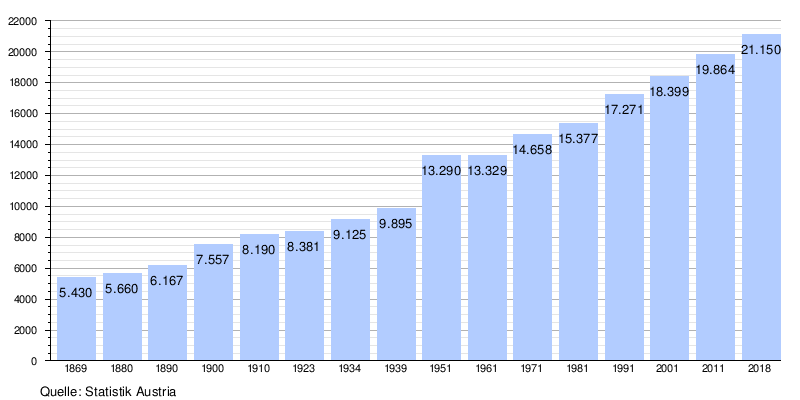
The population of Hallein increased from 1961 to 2001 from 13,329 to 18,399 inhabitants. This puts Hallein above the growing average for the district. One reason for this was the immigration of workers from Turkey and Yugoslavia in the 1970s, who were mainly needed for industry. Due to this strong influx, Hallein has increasingly developed into a multicultural small town in recent decades.
politics
The community council has a total of 25 members.
- With the municipal council and mayoral elections in Salzburg in 2004, the municipal council had the following distribution: 11 ÖVP, 10 SPÖ, 3 alliance for Hallein, and 1 FPÖ.
- With the municipal council and mayoral elections in Salzburg in 2009 , the municipal council had the following distribution: 15 ÖVP, 6 SPÖ, 2 FPÖ, and 2 Greens.
- With the municipal council and mayoral elections in Salzburg in 2014 , the municipal council had the following distribution: 13 ÖVP, 6 SPÖ, 2 FPÖ, 2 Greens, and 2 Neos.
- With the municipal council and mayoral elections in Salzburg 2019 , the municipal council has the following distribution: 9 SPÖ, 8 ÖVP, 3 Greens, 3 BASIS (formerly FPÖ), 1 Neos, 1 non-party (formerly ÖVP).
- mayor
- 1919–1934: Anton Neumayr (SPÖ)
- 1945–1946: Karl Nedomlel (KPÖ)
- 1946–1951: Rudolf Winkler (SPÖ)
- 1951–1958: Johannes Döttl (SPÖ)
- 1958–1976: Josef Brandauer (SPÖ)
- 1976–1987: Rudolf Müller (SPÖ)
- 1987–1995: Franz Kurz (SPÖ)
- 1995–1998: Franz Zambelli (SPÖ)
- 1998–1999: Ernst Scheichl (ÖVP)
- 1999–2013: Christian Stöckl (ÖVP)
- 2013–2018: Gerhard Anzengruber (ÖVP)
- 2018–2019: Maximilian Klappacher (ÖVP)
- since 2019: Alexander Stangassinger (SPÖ)
economy
With 53% organic farms, Hallein ranks first in the distribution of organic farms by political district (2011).
- Established businesses

- Robert Bosch GmbH (auto electrics, through takeover of: Friedmann & Maier)
- Erdal (shoe care)
- Hallein engine works : 1948 to 1958
- Emco (mechanical engineering)
- Hofbräu Kaltenhausen
- Trilety street cleaning machines
- State Clinic Hallein
traffic

- Street: Hallein has a connection to the A10 Tauern Autobahn in Gries (Exit 16 Hallein ). The B159 Salzachtal Straße runs through the city .
- Train: Hallein is located on the Salzburg-Tiroler-Bahn and, in addition to the train station, has a new S-Bahn stop in the Burgfried district that was built in autumn 2005 . The provincial capital Salzburg can be reached from Hallein with the regional express of the ÖBB and the line S3 ( S-Bahn Salzburg ) within 15 to 20 minutes.
- Cycle routes: The Tauern cycle path leads through the city, in Rif the salt trade path branches off to Bad Reichenhall .
media
- Bezirksblatt Tennengau, free newspaper (weekly), small format.
- Tennengauer Nachrichten, small format, 3 × monthly weekly supplement in the Salzburger Nachrichten , 1 × monthly free
- Halleiner Stadtzeitung 1999–2019, free newspaper (5 times a year), broadsheet format.
- Halleiner Zeitung 1952–1996, Kauf- und Abo-Zeitung (weekly), Berlin format, monthly with 5th edition as free newspaper in small format, 3 to 4 times a year with HZ color magazine on art paper (DIN A4 format).
- Regional newspaper Hello, free newspaper, small format (monthly).
- HSZ radio magazine for Hallein. Weekly radio broadcast of the Halleiner city newspaper as part of the Salzburg radio factory every Thursday afternoon.
- Culture and festival magazine Hallein 1999 to 2009 (annually), color magazine on art paper, A4 format.
- Salzachtaler, free newspaper (10 times a year), small format.
- Salzschreiber, online magazine, motto: The city of Hallein in sight .
- Publication by the municipality of Hallein, free medium, 4 times a year, DIN A4 format.
education
With 18 schools and more than 6,000 students, Hallein in Salzburg is generally regarded as a school town.
- 5 elementary schools
- 3 new middle schools
- Special education center
- Polytechnic school
- State vocational school Hallein
- Higher educational institution and technical school for business professions with a focus on wellness (until 2019)
- Higher technical college in Hallein : HTL for business informatics, business management, interior design & furniture construction, building construction, product and system design (Ecodesign), wood construction technology & carpentry. Technical schools for mechanical engineering, carpentry, stonemasonry, sculpture
-
Higher educational institute for fashion and clothing technology (Hallein fashion school)
- Higher school for hairstyling, make-up and make-up art
- College for fashion and clothing technology
- Federal Trade Academy and Federal Trade School
- Bundesgymnasium and Bundesrealgymnasium am Georgsberg
- University and State Sports Center Salzburg Rif (ULSZ Rif)
Culture and sights


- City wall, erected before 1300, only parts preserved, of the city gates only the Griestor and the Thürndl ruins , probably a corner point of the former city fortifications
- Old Town, a listed building, some with the Inn-Salzach construction built
- Gutrat castle ruins
- Alt-Gutrat ruins
- Gartenau Castle
- Wiespach Castle
- Benediktschlössl
- Egglauer Schlössel
- Altdorf Castle (Hallein)
- Stumbling blocks
- Churches
- Catholic parish church Hallein hl. Antonius Eremit: The Dechantkirche, east of it Dechanthof, attached to the rectory is the Peterskapelle, south of the Dechantkirche the death chapel
- Catholic parish church Hallein-Neualm hl. Joseph the worker
- Catholic parish church Hallein-Rehhof of Our Lady Queen of the Universe
- Catholic parish and pilgrimage church Dürrnberg Mariä Himmelfahrt
- Evangelical Schaitbergerkirche
- Bürgerspitalkapelle Hl. Cross
- Saltworks Chapel
- Cemetery chapel in the castle keep
- Former monastery church of St. George the Augustinian Hermits in Schützengasse
- Former Augustinian monastery
- Leper House Chapel St. Martin in Kaltenhausen
- Others
- town hall
- Colloredo brewhouse
- Saline official building
- Hofbräu Kaltenhausen company premises
- Culture
- Kulturforum Hallein: Organizer of cultural activities
- SUDHAUS hallein.kultur: Networking of regional cultural workers & organizers
- SalzSpiele Kulturverein: Kulturspiele in the Salzregion - is a member of the umbrella association Salzburg cultural sites and IG Kultur Österreich .
- Bodi end sole theater: Davisstrasse
- Tennengauer Kunstkreis - Gallery “KUNSTRAUM pro arte”: Schöndorferplatz
- Art in the vestibule: Bayrhamerplatz 8 - is a member of the umbrella organization Salzburg cultural sites and IG Kultur Österreich .
- Art community FreiRäume
- International Summer Academy Mozarteum Salzburg : some courses of the summer academy take place in the Alte Saline on the Pernerinsel in Hallein
- Salzburg Festival : several performances take place every year in the old salt works on the Pernerinsel
- Museums
- Silent Night Museum Hallein : The museum and grave of Franz Xaver Gruber , composer of the Christmas carol Silent Night , are located in Hallein, where he lived for many years
- Salt mine - Hallein salt mine near Salzburg : the salt mine offers two long miner's slides, a ride on the mine train, an underground raft ride on a salt lake and a Celtic village above ground
- Hallein Celtic Museum : the Celtic Museum is one of the most important collections of evidence of Celtic art in Europe
Sports
- Soccer
Football at club level has been played in the Celtic city since the 1920s. It all started with AC Hallein (Salzburg national champion and national cup winner in the 1930s) and SK Vorwärts Hallein . This tradition was continued by the 1st Hallein Sports Club (national champions and regional cup winners) and the SK Olympia 1948 Hallein . Today's figureheads in Hallein football are FC Hallein 04, founded in 2004, and Union Hallein .
- Gymnastics clubs
- ATSV Hallein
- TV Hallein
- Other sports clubs
- 1. KBC Hallein (kickboxing)
- 1. Hallein Chess Club
- 1. Hallein tennis club
- RC ARBÖ Hallein (cycling)
- ABC Luckypool Tennengau (pool billiards)
- Golf Club Salzburg facility Rif
- Archery Club Celtic Ravens Bad Dürrnberg
- Abada Capoeira
- 1. EV Hallein (Eisschützen)
- Hallein Ski Club (winter sports)
- HV-Hallein (dog club)
Hallein Fishing Association
- Cross-country run
The Wyndham Grand CrossAttack , held at the University and State Sports Center Salzburg / Rif, is one of the most important cross-country runs in Austria.
- Hiking trail
Within the village there is the Knappensteig
Personalities
- Virgil Pingitzer (1541 Hallein - 1619 Jena), legal scholar
- Johann Georg Mohr (around 1656 Radstadt - 1726 Hallein), Baroque sculptor, "Hallein Master"
- Joseph Schaitberger (1658 Dürrnberg near Hallein - 1733 Nuremberg), Protestant religious fighter
- Theresia Zechner (1697 Hallein - 1763 ibid), founder of the order of the Hallein School Sisters
- Conrad Franz Xaver Gruber (1787, Unterweitzberg - 1863, Hallein), composer "Silent Night, Holy Night"
- August Joseph Schenk (1815 Hallein - 1891 Munich), botanist
- Adolf Ritter von Steinhauser (1825 Hallein - 1888 Salzburg), councilor and honorary citizen of Salzburg
- Franz Xaver Gruber (1826 Lamprechtshausen - 1871 Hallein), founded the Halleiner Liedertafel in 1849
- Felix Gruber (1840 Hallein - 1884 ibid), teacher and organist, from 1863 choir regent in Hallein
- August Lohr (1842 Hallein - 1920 Mexico City, Mexico), landscape and panorama painter from the Munich School, from 1885/90 in the USA and Mexico
- Jakob Adlhart the Elder Ä. , (1871 in Achdorf - 1956 in Hallein), wood carver, gilder and barrel painter
- Jakob Gruber (1864 Hallein - 1915 Vienna), sculptor
- Max Domenig (1886 Obervellach - 1952 Hallein), sculptor
- Clemens Holzmeister (1886 Fulpmes - 1983 Hallein), architect and honorary citizen of Salzburg
- Moriz Gelinek (1887 Hallein - 1979 Salzburg), railway pioneer and entrepreneur
- Anton Neumayr (1887 Salzburg - 1954 ibid), Mayor of Hallein and Salzburg
- Jakob Adlhart the Elder J. (1898 Munich - 1985 Hallein), sculptor
- Otto Strohmayr (1900 Hallein - 1945 Hallein-Kaltenhausen), architect
- Agnes Primocic (1905 Hallein - 2007 ibid), politician and resistance fighter
- Wolfgang Mittermayer (1911 Hallein - 1969 ibid), painter and draftsman
- Edmund Stierschneider (1911 Vienna - 1996 Hallein), professor, acad. Painter, founder of the Halleiner Zeitung, initiator of the Halleiner Gymnasium
- Sepp Plieseis (1913 Bad Ischl - 1966 ibid), mountaineer, resistance fighter , fled from the subcamp in Vigaun near Hallein
- Ernst Penninger (1919 Hallein - 1995 ibid), local history researcher and archaeologist
- Bernhard Prähauser (* 1921 Hallein), sculptor
- Edmund Molnar (1923 Hallein - 1944 Berlin Tegel), locksmith, corporal of the Wehrmacht, executed for alleged "undermining military strength"
- Herbert Fux (1927 Hallein - 2007 Salzburg), popular actor and politician
- Anton Karl (1935 Hallein - 2015 Salzburg), politician (ÖVP) and master butcher
- Jakob Adlhart (* 1936 Hallein), architect
- Karl Moik (1938 Linz - 2015 Salzburg), television presenter and entertainer; grew up in Hallein
- Johann Sallaberger (1938 Hallein - 2016), Roman Catholic church historian
- Odo Stierschneider (* 1939 Leoben), editor of the Halleiner Zeitung (1970–1996), editor of the Hallein festival magazine (1999–2009), publisher of the Hallein internet magazine Salzschreiber since 2009
- Bruno Becker (* 1945 Hallein), retired Archabbot of St. Peter Abbey in Salzburg
- Kurt Zeller (1945 Hallein - 2009 ibid), director of the Hallein Celtic Museum and head of the Dürrnberg research center.
- Manfred Riederer (* 1946 Hallein), painter and draftsman
- Otto Kruse (* 1948), psychologist, writing researcher and university professor
- Gottfried Bär (* 1952 Hallein), former table tennis player
- Manfred Baumann (* 1956 Hallein), journalist, author, cabaret artist and ORF editor
- Gerhard Anzengruber (* 1958 Hallein), Mayor of Hallein
- Erhard Riedlsperger (* 1960 Hallein), screenwriter and director
- Lukas Essl (1965 Hallein - 2019), coachbuilder and politician
- Thomas Stangassinger (* 1965 Hallein), former ski racer
- Judith Wiesner (* 1966 Hallein), former tennis player
- Herbert Ilsanker (* 1967 Hallein), former soccer player
- Alarich Lenz (* 1967 Hallein), film editor
- Michael Wildner (* 1970 Hallein), former athlete
- Sanel Kuljic (* 1977 Salzburg), childhood in Hallein, national soccer player
- Daniel Kastner (* 1981 Hallein), soccer player
- Mareike Fallwickl (* 1983 Hallein), author
- Georg Oberauer (* 1984 Hallein), church musician
- Stefan Ilsanker (* 1989 Hallein), football player
- Anna Veith (* 1989 Hallein), ski racer
- Marcel Hirscher (* 1989 Hallein), former ski racer
See also
Web links
- 50205 - Hallein. Community data, Statistics Austria .
- Community website
- District administration Hallein
- Silent Night Hallein
Individual evidence
- ↑ Mayoral elections on March 10 and 24, 2019 , salzburg.gv.at, accessed on March 24, 2019
- ↑ Stich-Wort on DrehPunktKultur accessed on April 12, 2018:
- ↑ Geography & Climate. In: www.tennengau.com. Retrieved May 24, 2020 .
- ↑ Tennengau Almkäse. In: www.bmlrt.gv.at. Retrieved May 24, 2020 .
- ↑ Statistics Austria: Population on January 1st, 2020 by locality (area status on January 1st, 2020) , ( CSV )
- ↑ Zillner, Dr. Franz, Valentin: On the history of the Salzburg salt system. Economic reviews and local history explanations. Salzburg 1879. p. 8 ff
- ↑ Entry on Hallein in the Austria Forum (in the AEIOU Austria Lexicon )
- ↑ From 200 AD there are images of nobles in typical Celtic costumes. The Salzburg diocese emerged in the 5th century, shortly after the Roman citizens had left.
- ↑ Did you know that ... Hallein was formerly called Mühlbach? sn.at, August 13, 2018, accessed November 23, 2019.
- ↑ pronunciation hallein in German de.forvo.com, accessed 23 November 2019. - voice sample.
- ^ Wagner, H. F: Topographie von Alt-Hallein in: MGSLK 55, 1915, pp. 1-44.
- ↑ Picture of the tunnel system in spon October 20, 2015 from Solveig Grotto; or in St. Georgen an der Gusen : rock crystal
- ^ Exhibition 2011/12: Armaments factory under the highest secrecy
- ^ Grill works in Salzburgwiki
- ↑ Commemorative plaque in memory of the Hallein satellite camp remembrance.at, January 18, 2012, accessed November 23, 2019. - Placement of privately financed memorial plaques.
- ^ Concentration camp Dachau satellite camp in Hallein secretprojekte.at, May 4, 2015 or later, accessed November 23, 2019.
- ↑ https: //www.Gedenkfeier KZ satellite camp Hallein mein district.at, May 2, 2016, accessed November 23, 2019.
- ↑ Privately erected memorial plaque for the Hallein concentration camp derstandard.at, January 18, 2012, accessed November 23, 2019.
- ↑ Austrian Brewing Union: The Home of Edelweiss ( Memento from October 18, 2007 in the web archive archive.today )
- ↑ Rainer Lidauer, Malvine Stentel: The population of the town of Hallein. A structural investigation based on the civil status record from October 1970. In: Mitteilungen der Gesellschaft für Salzburger Landeskunde. (MGSLK), Vol. 114, 1974, pp. 311-340.
- ↑ Mayor of the City of Hallein since 1945. City of Hallein, accessed on December 14, 2019
- ^ Franz Zambelli . In: Salzburger Nachrichten : Salzburgwiki .
- ↑ Ernst Scheichl . In: Salzburger Nachrichten : Salzburgwiki .
- ^ Christian Stoeckl . In: Salzburger Nachrichten : Salzburgwiki .
- ↑ Gerhard Anzengruber . In: Salzburger Nachrichten : Salzburgwiki .
- ^ Klappacher new mayor of Hallein on ORF-Salzburg from December 14, 2018, accessed on December 15, 2018.
- ↑ Hallein has a new mayor: Maximilian Klappacher on mein district.at from December 13, 2018, accessed on December 15, 2018.
- ↑ Maximilian Klappacher . In: Salzburger Nachrichten : Salzburgwiki .
- ↑ Alexander Stangassinger . In: Salzburger Nachrichten : Salzburgwiki .
- ^ Hallein loses city newspaper. salzburg.orf.at, December 20, 2019, accessed on December 20, 2019 .
- ↑ Salzschreiber. Hallein in sight: critical, constructive, provocative, visionary. Retrieved December 23, 2012 .
- ^ Insights into the Hallein Sculpture School 2010 on YouTube , accessed on December 23, 2012
- ↑ a b c d e f g h i j Dehio Salzburg 1986
- ↑ SalzSpiele - cultural games in the salt region. Retrieved February 18, 2020 .


Cadastral communities: Adnet II • Au • Burgfried • Dürnberg • Gamp • Gries • Hallein • Oberalm II • Taxach
Locations: Adneter Riedl • Au • Bad Dürrnberg • Burgfried • Gamp • Gries • Hallein • Neualm • Taxach
Districts:
Adneter Gries •
Adneter Riedl •
Au •
Bad Dürrnberg •
Gamp •
Burgfried •
Hallein •
Neualm •
Taxach
Village:
Bad Dürrnberg ••
Weiler:
Kaltenhausen •
Gasting ••
Rotten:
Au •
Gamp •
Gartenau •
Gmerk •
Gutrathberg •
Kranzbichl •
Plaick •
Winterstall ••
settlements:
Adnet Riedl •
Hühnerau •
Rehhofsiedlung •
Rif •
Taxach ••
houses Group:
Schloss Rif •
university and Regional Sports center Salzburg |
Scattered houses:
Fish Point directing •
Mitterau ••
Other local materials:
. Chem factory •
ruin Gutrath •
Schloßbauer •
ruin Thürndl •
Castle Wiespach •
cement factory
Counting district: City center: Hallein-Zentrum •• City area close to the center : Oberalm-Süd • Hallein-Innen-Ost • Hallein-Innen-Südost • Hallein-Innen-Süd • Gries - Adneter-Riedl •• Northern edge zone: Kaltenhausen - Au • Neualm • Taxach • Döllererfeld settlement •• Southern rural outskirts: Gamp • Dürrnberg