
Boldekow
| coat of arms | Germany map | |
|---|---|---|

|
Coordinates: 53 ° 43 ' N , 13 ° 36' E |
|
| Basic data | ||
| State : | Mecklenburg-Western Pomerania | |
| County : | Vorpommern-Greifswald | |
| Office : | Anklam Land | |
| Height : | 14 m above sea level NHN | |
| Area : | 48.38 km 2 | |
| Residents: | 659 (Dec. 31, 2019) | |
| Population density : | 14 inhabitants per km 2 | |
| Postal code : | 17392 | |
| Area code : | 039722 | |
| License plate : | VG, ANK, GW, PW, SBG, UEM, WLG | |
| Community key : | 13 0 75 015 | |
| LOCODE : | DE 9B6 | |
| Community structure: | 8 districts | |
| Office administration address: | Rebelower Damm 2 17392 Spantekow | |
| Website : | ||
| Mayor : | Holger Vogel ( CDU ) | |
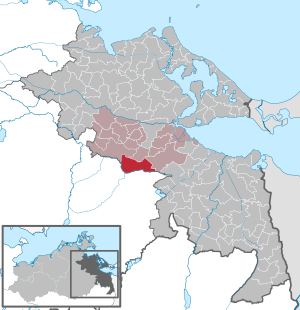
| Location of the municipality of Boldekow in the Vorpommern-Greifswald district | ||
  |
||

Boldekow is a municipality in the district of Vorpommern-Greifswald . Since January 1, 2005, the municipality has been administered by the Anklam-Land office based in the municipality of Spantekow . Until December 31, 2004 the community belonged to the Spantekow office .
Geography and traffic
Boldekow is located on Bundesstrasse 197 . Anklam is about 17 kilometers north and Neubrandenburg 31 kilometers southwest of the municipality. The federal motorway 20 can be reached via the connection Neubrandenburg-Nord (approx. 19 km). The Große Landgraben crosses the south of the municipality . The northern part of the municipality lies on a terminal moraine .
Districts
|
|
history

Boldekow
Boldekow was first mentioned in 1313 as Wendeschen Boldekow . The current name was not used until 1779. The village center of Boldekow emerged from the Slavic original settlement in the period from 1739 to 1752 in a little changed place.
Boldekow is a street village, the estate did not have a dominant location. In terms of function, however, it was still an estate and church village.
During the war of Prussia in 1806 against the army of Napoleon Bonaparte , part of the Prussian army surrendered on October 30th in Boldekow .
Only insignificant remains of the estate are left, even the estate park was built on.
Borntin
Borntin was first mentioned as Borrentyn in 1533 . The name commonly used today has only been used since 1932. In 1533, however, the village was still a desert field mark when it was notarized, it was only rebuilt later.
Borntin is located on the Landgraben, the border between Pomerania and Mecklenburg. It is a manor village in form and function. A water mill belonging to Borntin was located on the ditch. The mill pond and mill disappeared before 1880 ( table sheet , MTB).
On July 1, 1950 Borntin was incorporated.
Glien
Glien was first mentioned in 1236 as Gline . The current name was not used until 1698. The Slavic name means Glina = clay .
According to MTB 1880, Glien consisted of two parts, the Angerdorf and the eastward manor.
Glien settlement
Gliener Siedlung was marked as Gliener Mühle in the measurement table sheets in 1880 and 1920 because there was a windmill there. It was not until 1998 that the name Gliener Siedlung was listed in the municipal registers, because the new farmers' farms had now emerged there.

Kavel Pass
Kavel Pass was first mentioned in 1308 as Koghele . In 1809 an interesting variant of the name was used - the Kabel Pass , which shows the interpretation of the name by Berghaus, who explains the name by saying that customs justice was raffled, that is, "Kabelvertheilt" was made. In 1865, the spelling Kavelpass followed, with spellings with "C" also appearing later.
Kavelpass was a small settlement of colonists along the road to Friedland . A border customs post was located here between Prussian Pomerania and the Grand Ducal Mecklenburg.
During the Seven Years' War a battle between Swedish and Prussian troops took place near Kavelpass in August 1760. Gebhard Leberecht von Blücher, who was fighting on the Swedish side at the time , was captured. The large boulder there on the Kavel pass was named " Blücherstein " in his honor . Fortunately, the high point with the stone was left out of the gravel pit next to it. From the point of view of a medieval tower hill, the so-called Grafenstuhl was built as a vantage point in 1833 with the construction of the road from Kavelpass to Zinzow. It was built of hewn granite in a round shape with a platform. Count von Schwerin auf Zinzow had made land and material available for this, hence “Grafenstuhl”.
Putzar
Putzar was first mentioned in 1306 as Potzare . The meaning of the name is given as "village of the princely dog guards".
On January 1, 2012, the municipality of Putzar was incorporated into Boldekow.
Rubenov
Rubenow was first mentioned in 1285 as "Rubekow". The Slavic name is interpreted as "place on the water".
Zinzow
Zinzow was first recorded as "Zinsow" in 1618 on the Lubin map. The Slavic name is interpreted as "Heubach" or "Wiesenbach".
On January 1, 1999, the previously independent Zinzow was incorporated into Boldekow.
Bornmühl (desert)
Bornmühl was a settlement on what is now the Peene-Südkanal. In 1747 a Born mill or art mill was built there as a water and wind mill. Born means well or spring, this was in the area. The place was named after her. Later, a manor was also created, which was then converted into a Vorwerk at Boldekow. The place name Bornmühl was first recorded in 1822. Because of clay deposits, a brick factory was built northeast of the place. All of these operations were discontinued and eliminated before 1865. Ruins are still recorded in the measuring table from 1880 and 1920.
Jägersruh (living space)
Jägersruh was first mentioned in a document in 1851. It is a forester's house about 3 km northwest of Boldekow in the forest area and is counted to this place today. It is shown in the current maps as an independent settlement.
Musenbeke (desert)
In 1324 the place Musenbeke was first mentioned in a document. The place was between the Kavel Pass and Zinzow and was already desolate in 1533. The name is only preserved as a field name.
New Putzar (living space)
New Putzar is first recorded in the 1998 topographic map.
Development of the population
- 1817: 203
- 1865: 136
- 2010: 534
politics
Coat of arms, flag, official seal
The municipality has no officially approved national emblem, neither a coat of arms nor a flag . The official seal is the small state seal with the coat of arms of the region of Western Pomerania . It shows an upright griffin with a raised tail and the inscription "GEMEINDE BOLDEKOW * LANDKREIS VORPOMMERN-GREIFSWALD".
Attractions
→ See also the list of architectural monuments in Boldekow
- Boldekow Church : Gothic hall church made of field stone from 13./15. Century.
- Putzar Church : Hall church from 1560 from the Renaissance with roof tower from 1705 made of brick.
- Ruins of the manor houses in Putzar with Ulrichsbau from around 1550 made of field stone for Grand Court Master Ulrich von Schwerin and Joachim's building from around 1580 for son Joachim.
- Park around Putzar Castle from 1840 to 1880 with remarkable individual trees; Renovation since around 2000.
- Zinzow Castle: Neo-Baroque plastered building from 1907 with a mansard roof , basement and central risalit on both sides
- 14 hectare landscape park around Zinzow Castle.
- Zinzow distillery as a renovated clinker building on a field stone base.
- Blücherstein near the Kavel Pass, a boulder with a circumference of eleven meters.
- Grafenstuhl tower hill in the Kavel pass.
- Ditch; Valley with transition to the Kavel pass.
- Zinzow barrow field
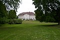
Zinzow Castle and Park

Estate distillery in Zinzow

Blücherstein on the Kavel pass


Sons and daughters of the village
- Maximilian Heinrich Karl Graf von Schwerin-Putzar (1804–1872), member of parliament and manor owner
- Kurt Sprengel (1766–1833), botanist and physician
literature
- Manfred Niemeyer: East Western Pomerania. Collection of sources and literature on place names. Vol. 2: Mainland. (= Greifswald contributions to toponymy. Vol. 2), Ernst-Moritz-Arndt University of Greifswald, Institute for Slavic Studies, Greifswald 2001, ISBN 3-86006-149-6 .
- Hubertus Neuschäffer: Western Pomerania's castles and mansions. Husum Druck- und Verlagsgesellschaft 1993, p. 222, ISBN 3-88042-636-8
Web links
Individual evidence
- ↑ Statistisches Amt MV - population status of the districts, offices and municipalities 2019 (XLS file) (official population figures in the update of the 2011 census) ( help ).
- ^ A b Heinrich Berghaus : Land book of the Duchy of Pomerania and the Principality of Rügen , Part II, Volume 1.
- ↑ a b c d e f g h i j k l Manfred Niemeyer: Ostvorpommern . Collection of sources and literature on place names. Vol. 2: Mainland. (= Greifswald contributions to toponymy. Vol. 2), Ernst-Moritz-Arndt University of Greifswald, Institute for Slavic Studies, Greifswald 2001, ISBN 3-86006-149-6 . P. 11 ff
- ^ Eduard von Höpfner : The war of 1806 and 1807. A contribution to the history of the Prussian army . 1st part: The campaign of 1806 , 2nd volume, 2nd edition, Berlin 1855, pp. 233-239
- ↑ Anklam 1865, pp. 291-292 ( online ).
- ^ Georg Winter: Pomeranian document book . (PUB) No. 2294, 4th volume 1301-1310. , Paul Niekammer, Stettin 1903, pp. 230-231.
- ↑ Amt Anklam-Land, see under No. 27 .
- ↑ StBA: Changes in the municipalities in Germany, see 1999
- ↑ List of localities of the government district of Stettin according to the new district division from 1817 including alphabetical register . Stettin 1817, printed by Carl Wilhelm Struck, p. 23 ( online ).
- ↑ Main Statute, Section 1, Paragraph 2 (PDF).
Ahlbeck | Old Tellin | Altwarp | Altwigshagen | Anklam | Bandelin | Bargischow | Behrenhoff | Bentzin | Benz | Mountain wood | Blankensee | Blesewitz | Boldekow | Boock | Brietzig | Brünzow | Bugewitz | Buggenhagen | Butzow | Daberkow | Dargelin | Dargen | Dersekow | Ducherow | Eggesin | Fahrwalde | Ferdinandshof | Garz | Glazov | Görmin | Grambin | Grambov | Greifswald | Gribow | Gross Kiesow | Groß Luckow | Great Polzin | Gützkow | Hammer ad Uecker | Hanshagen | Heinrichswalde | Heringsdorf | Hinrichshagen | Hintersee | Iven | Jarmen | Jatznick | Comb teeth | Karlsburg | Karlshagen | Katzow | Kemnitz | Klein Bünzow | Koblentz | Korswandt | Koserow | Krackow | Krien | Kröslin | Kruckow | Krugsdorf | Krummin | Krusenfelde | Lassan | Leopoldshagen | Levenhagen | Liepgarten | Löcknitz | Loddin | Loissin | Loitz | Lubmin | Luebs | Luckow | Luetow | Medow | Meiersberg | Mellenthin | Mesekenhagen | Mölschow | Mönkebude | Murchin | Nadrensee | Neetzow-Liepen | New Boltenhagen | New Kosenow | Neuenkirchen | Neuenkirchen | Low | Papendorf | Pasewalk | Peenemünde | Penkun | Plow | Polzow | Postlow | Pudagla | Ramin | Rankwitz | Rollwitz | Rossin | Rossow | Rothemühl | Rothenklempenow | Rubenov | Rubkov | Sarnow | Sassen-Trantow | Sauzin | Schmatzin | Schönwalde | Spantekow | Stumble on the Peene | Stolpe on Usedom | Strasburg (Uckermark) | Torgelow | Trassenheide | Tutow | Ückeritz | Ueckermünde | Usedom | Square | Vogelsang-Warsin | Völschow | Wackerow | Weitenhagen | Wilhelmsburg | Wolgast | Wrangelsburg | Wusterhusen | Zemitz | Zempin | Zerrenthin | Ziethen | Zinnowitz | Zirchow | Züssow