Pohl (Nassau)
| coat of arms | Germany map | |
|---|---|---|

|
Coordinates: 50 ° 15 ' N , 7 ° 52' E |
|
| Basic data | ||
| State : | Rhineland-Palatinate | |
| County : | Rhein-Lahn district | |
| Association municipality : | Bad Ems-Nassau | |
| Height : | 330 m above sea level NHN | |
| Area : | 4.24 km 2 | |
| Residents: | 322 (Dec. 31, 2019) | |
| Population density : | 76 inhabitants per km 2 | |
| Postal code : | 56357 | |
| Area code : | 06772 | |
| License plate : | EMS, DIZ, GOH | |
| Community key : | 07 1 41 111 | |
| Association administration address: | Am Adelsheimer Hof 1 56377 Nassau |
|
| Website : | ||
| Local Mayor : | vacant (substitute for Holger Güth, first deputy) | |
| Location of the local community of Pohl in the Rhein-Lahn district | ||

Pohl is a rural Taunus community in the Nassau Nature Park . It lies in the area of the medieval Einrichgau and today belongs to the Rhineland-Palatinate Rhein-Lahn district . The local community belongs to the Bad Ems-Nassau community .
geography
location
Pohl is located in the northwest of the Taunus (western Hintertaunus ) , around 10 kilometers south of the Lahn . On a ridge between the Mühlbachtal in the west and Dörsbachtal and Hasenbachtal in the east, the place lies at an altitude of 330 m above sea level. NHN .
Land use
The area of the district is 423 hectares. In 1997 45.3% of this was forest (of which about 91 hectares are in the so-called "Pohler Berg" forest enclave near the municipality of Roth ), 44.7% agricultural areas, 5.9% accounted for traffic area, 2.1% for buildings and open space and 0.5% for water areas (Dörsbach, Hasenbach, Sommerbach and Hauserbach with backwaters and impoundments).
history
The area around Pohl was already settled by the Celts in pre-Christian times , as can be seen in the barrows . The Romans later settled the area and left clear traces with the remains of the Limes in the Pohl forest.
- For the Roman past of the place see also the separate article Small fort Pohl .
The place was first mentioned in a document on the occasion of a donation to the Arnstein Monastery in 1247.
The Pohl primary school existed from 1873 to 1970.
religion
While the villages in the area have been Protestant throughout since the Reformation , Pohl's population has been mixed for centuries. About two thirds of the population was Catholic and one third was Protestant. Today both religious communities are balanced.
The Catholic parish “Mariä Himmelfahrt”, which is looked after by a pastor together with the parishes of Katzenelnbogen and Zollhaus, has the parish church from 1875. The small medieval church of Niedertiefenbach is used by the Evangelical parish .
Population development
The population developed as follows in the 19th and 20th centuries: 1843: 140 inhabitants, 1927: 253 inhabitants, 1964: 265 inhabitants. At the end of 2006, Pohl had 343 residents.
politics
Municipal council
The municipal council in Pohl consists of eight council members, who were elected by a majority vote in the local elections on May 26, 2019 , and the honorary local mayor as chairman.
mayor
The office of the local mayor of Pohl is vacant. No candidate ran for the direct election on May 26, 2019. In this case, the municipal ordinance provides for an election by the municipal council, but the council was unable to find a successor to the previous mayor, Thomas Steffen. The community is currently represented by First Alderman Holger Güth.
coat of arms
|
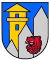
Blazon : “In blue on the right a golden Limes tower, which is covered by two of three silver palisades rising at an angle to the left. The two palisades on the left are occupied by a red lion head. "
The coat of arms was designed by Albert Perabo and approved by the district on September 4, 1992. |
|
| Justification of the coat of arms: The local coat of arms is linked to Roman times. It is represented by a watchtower, as it has stood in several places in the Pohl district, as well as by three Limes palisades. The coat of arms is complemented by a lion's head. For more than 600 years, Pohl belonged to mansions that had the lion in their coat of arms - starting with Count Heinrich II. Of Nassau , to whom Pohl owes the first documentary mention, to the Counts of Katzenelnbogen and those of Hesse up to the Duchy of Nassau . |
Economy and Infrastructure
traffic
The federal highway 260 , which connects Koblenz and the Lahn valley with Wiesbaden and the Rhine-Main area , is Pohl's most important traffic artery. This street is part of the Bäderstraße and the Deutsche Limes-Straße in the Pohl area .
Bike trails
The German Limes Cycle Path runs through Pohl . This follows the Upper German-Raetian Limes over 818 km from Bad Hönningen on the Rhine to Regensburg on the Danube .
See also
Web links
- Internet presence of the local community Pohl
- Local community Pohl on the website of the Bad Ems-Nassau community
Individual evidence
- ↑ State Statistical Office of Rhineland-Palatinate - population status 2019, districts, communities, association communities ( help on this ).
- ^ The Regional Returning Officer Rhineland-Palatinate: Municipal Council Election 2019 Pohl. Retrieved November 4, 2019 .
- ^ The State Returning Officer Rhineland-Palatinate: direct elections 2019. see Bad Ems-Nassau, Verbandsgemeinde, 20th line of results. Retrieved November 4, 2019 .
- ^ Verbandsgemeinde Bad Ems-Nassau: Ortgemeinde Pohl. Contact Person. Retrieved November 4, 2019 .


