
Berkenthin
| coat of arms | Germany map | |
|---|---|---|

|
Coordinates: 53 ° 44 ' N , 10 ° 38' E |
|
| Basic data | ||
| State : | Schleswig-Holstein | |
| Circle : | Duchy of Lauenburg | |
| Office : | Berkenthin | |
| Height : | 19 m above sea level NHN | |
| Area : | 10.25 km 2 | |
| Residents: | 2082 (Dec. 31, 2019) | |
| Population density : | 203 inhabitants per km 2 | |
| Postal code : | 23919 | |
| Area code : | 04544 | |
| License plate : | RZ | |
| Community key : | 01 0 53 009 | |
| LOCODE : | DE B4V | |
| Office administration address: | Am Schart 16 23919 Berkenthin |
|
| Website : | ||
| Mayor : | Friedrich Thorn (BWI) | |
| Location of the community Berkenthin in the Duchy of Lauenburg district | ||
  |
||

Berkenthin is a municipality in the Duchy of Lauenburg in southeastern Schleswig-Holstein . Berkenthin is the rural central town and administrative seat of the office of the same name . Kählsdorf is in the municipality.
Geography and traffic

Berkenthin is shaped by the Elbe-Lübeck Canal and is located southeast of the Hanseatic city of Lübeck . The place consists of two districts, Klein-Berkenthin west of the canal and Groß-Berkenthin on the eastern side of the canal. The two districts are connected by a steel bridge connected with each other, this bridge performs the Federal Highway 208 . The bridge can be heated. In the southern area, a pedestrian bridge crosses the canal and leads directly to the historic Maria Magdalenen Church. The entire eastern part of the municipality is part of the Lauenburg Lakes Nature Park .
The federal highway 208 leads through Berkenthin from Ratzeburg to Bad Oldesloe . The new Baltic Sea motorway passes around eight kilometers north of the community. The Lübeck-Blankensee regional airport is twelve kilometers away .
By 1962 Berkenthin also had a train station on the so-called Kaiserbahn from Hagenow via Ratzeburg to Bad Oldesloe. The route was removed from 1972, the nearby bridge over the Elbe-Lübeck Canal existed until a few years ago.
history
The place was mentioned for the first time in the Ratzeburg tithe register in 1230 . The early Gothic Maria Magdalenen Church also dates from this period. In 1264 the Bishop of Ratzeburg awarded half of the tithes of the village Parketin to a local noble family who owned the noble estate and court of Klein Berkenthin until 1681. Woltersdorf was subsequently owned by the Hanseatic City of Lübeck . Due to the comparison of 1747 in Hanover, the place fell to the Duchy of Lauenburg .
Since 1420, north of Berkenthin, there has been evidence of a medieval leprosy, which was called the St. Jürgen Hospital.
In 1900 the Elbe-Lübeck Canal was inaugurated. On October 1, 1938, the Lauenburg communities Groß Berkenthin, Klein Berkenthin, Kählstorf and Göldenitz as well as the Lubbian town of Hollenbeck were merged to form the community Berkenthin. On April 1, 1951, Göldenitz became an independent municipality again. On April 1, 1954, Hollenbek moved to the community of Behlendorf. In 1974 Berkenthin was classified as a rural central place. In 1985 the municipality received approval to use its own coat of arms. In 1991, a sports center was built on the site of the former sawmill to promote sporting activities. A grass sports field, an artificial turf field, two tennis courts and a multi-purpose room have served the surrounding communities as a contact point for all things sports ever since.
politics
coat of arms
Blazon : “Divided. Above in red a silver sloping strip with three clover leaves, below divided diagonally three times by black and silver. "
The silver sloping bar comes from a seal of the local nobleman Detlev von Parkentin from the 13th century.
Community representation
Since the local elections on May 6, 2018, the municipal council has been composed as follows.
| Political party | Number of community representatives |
|---|---|
| Social Democratic Party of Germany (SPD) | 7th |
| Berkenthiner voter initiative | 5 |
| Individual applicants | 1 |
Maria Magdalenen Church
The Maria Magdalenen Church in Berkenthin was built around 1230. However, a tax list from 1194 already mentions a church in Berkenthin. The Maria Magdalenen Church has medieval and medieval wall paintings from the 19th century, a late Baroque altar, a figure of Maria Magdalena from the 15th century, a tree trunk cross from the 14th century and a baptismal angel from 1734. The masonry suggests that the church was destroyed several times. There are no records of this. Today's pointed church tower did not replace the previous construction with four gables and a small wooden tower until 1967. The church has been Protestant since around 1530–1543.
There are various theories about its name: It is possible that the church was founded in connection with the Battle of Bornhöved (1227) against the Danes. This battle took place on Mary Magdalene Day (July 22nd). During this battle, Count Adolf IV. Von Schauenburg and Holstein had sworn to donate churches or monasteries to Maria Magdalene in the event of a victory. In close proximity, the Burgkloster (1227) was founded in Lübeck as St. Mary Magdalene Monastery of the Dominicans, which dates back to the victorious battle of Count Adolf IV near Bornhöved.
Another theory is based on the Stecknitz drivers, whose patron saint was Maria Magdalena. The river boatmen on the Salzprähmen also called themselves the Maria Magdalenen Brotherhood of the Stecknitz drivers. The Berkenthiner Church was one of the Stecknitzfahrer churches (as well as Krummesse, Witzeeze and Siebeneichen). The Stecknitz boatmen attended church services here, had their own church stalls and their own burial place in the church cemetery in Berkenthin. The graves of the Stecknitz drivers are still preserved in the cemetery in front of the church.
Around 1832 the church was unofficially dedicated to the patron Peter, who is depicted twice in the church. The church was originally known without a name as "Church in Berkenthin" until it was baptized in March 2008 with the name "Maria Magdalenen Church".
Attractions
The list of cultural monuments in Berkenthin includes the cultural monuments entered in the list of monuments of Schleswig-Holstein.
The lock on the Elbe-Lübeck Canal, built in 1900, is operated according to the Hotopp principle using only water power.
photos

Canal lock

Berkenthin Church as seen from the old pedestrian bridge over the canal
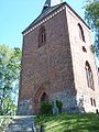
Church tower from the entrance of the churchyard

Maria Magdalenen Church


Web links
Individual evidence
- ↑ North Statistics Office - Population of the municipalities in Schleswig-Holstein 4th quarter 2019 (XLSX file) (update based on the 2011 census) ( help on this ).
- ↑ Aasbüttel - Bordesholm . In: Wolfgang Henze (ed.): Schleswig-Holstein topography: cities and villages of the country . 1st edition. tape 1 . Flying-Kiwi-Verl. Junge, Flensburg 2001, ISBN 3-926055-58-8 , p. 295 .
- ↑ Berkenthin: New bridge with underfloor heating . sh: z Schleswig-Holsteinischer Zeitungsverlag GmbH & Co. KG. January 13, 2009. Retrieved April 19, 2019.
- ↑ see data from the Society for Leprosy. Archived copy ( memento of the original from December 10, 2014 in the Internet Archive ) Info: The archive link was inserted automatically and has not yet been checked. Please check the original and archive link according to the instructions and then remove this notice.
- ↑ Schleswig-Holstein's municipal coat of arms
- ^ Election officers: Announcement of the municipal election results for all municipalities. In: Official notices - Office Berkenthin. Office Berkenthin, May 14, 2018, accessed May 19, 2018 .
Albsfelde | Alt-Mölln | Aumühle | Bäk | Blue | Basedow | Basthorst | Behlendorf | Berkenthin | Besenthal | Bliestorf | Exchanges | Borstorf | Breitenfelde | Bröthen | Brunsmark | Brunstorf | Books | Buchholz | Buchhorst | Dahmker | Dalldorf | Dassendorf | Düchelsdorf | Duvensee | Single house | Elmenhorst | Escheburg | Fitzen | Fredeburg | Fuhlenhagen | Geesthacht | Giesensdorf | Göldenitz | Goddess | Grabau | Grambek | Grinau | Big floor | Great Disnack | Groß Grönau | Great Pampau | Great Sarau | Groß Schenkenberg | Grove | Gudow | Gülzow | Bream | Hamfelde | Hamwarde | Harmsdorf | Havekost | Hohenhorn | Hollenbek | Hornbek | Horst | Juliusburg | Kankelau | Kasseburg | Kastorf | Kittlitz | Klein Pampau | Klein reveler | Plumbing | Klinkrade | Koberg | Kollow | Koethel | Kröppelshagen-Fahrendorf | Krukow | Curved mass | Krüzen | Kuddewörde | Killing | Kulpin | Labenz | Langenlehsten | Lankau | Lance | Lauenburg / Elbe | Clay wheel | Linau | Lüchow | Lütau | Mechow | Möhnsen | Mölln | Mill wheel | Must | Mustin | Niendorf ad St. | Niendorf near Berkenthin | Nuts | Panting | Pogeez | Poggensee | Ratzeburg | Ritzerau | Römnitz | Rondeshagen | Roseburg | Sahms | Salem | Sandesneben | Schiphorst | Schmilau | Schnakenbek | Schoenberg | Schretstaken | Schulendorf | Poking soles | Schwarzenbek | Seedorf | Seven trees | Seven oaks | Sierksrade | Sirksfelde | Steinhorst | Sterley | Stump | Talkau | Tramm | Walksfelde | Wangelau | Wentorf (Amt Sandesneben) | Wentorf near Hamburg | Wiershop | Witzeeze | Wohltorf | Woltersdorf | Worth | Ziethen
Community-free area in the Duchy of Lauenburg
Sachsenwald district