Istria
| Istria | ||
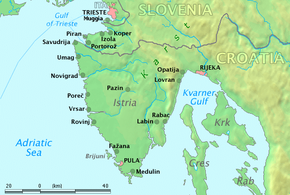 Map of Istria |
||
| Geographical location | ||
|
|
||
| Coordinates | 45 ° 9 ' N , 13 ° 55' E | |
| Waters 1 | Gulf of Trieste | |
| Waters 2 | Adriatic | |
| Waters 3 | Kvarner Bay | |
| length | 80 km | |
| width | 60 km | |
| surface | at 3 500 km² | |
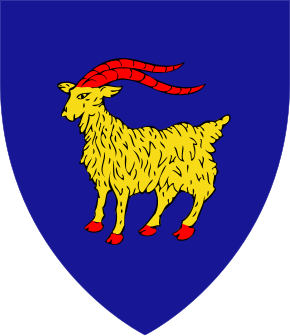 Coat of arms of Istria, from the crown of the coat of arms of Croatia |
||
Istria ( Croatian / Slovenian Istra , istriotisch Eîstria , Italian Istria , lat. Histria ), with an area of about 3,500 square kilometers, the largest peninsula on the northern Adriatic between the Gulf of Trieste and the Kvarner Bay in front of Rijeka .
The name Istria goes back to the name of the Histrians who lived in this region in ancient times. It is controversial and unclear whether this tribe belongs to the Venetians or to the Illyrians .
Political structure
The vast majority of Istria belongs to Croatia , part of the north to Slovenia and a small stretch of land around the village of Muggia to Italy . The Croatian part of Istria is - with the exception of the area around the town of Opatija , which the county ( district , county ) Primorje-Gorski Kotar (Croatian Primorje-Gorski Kotar županija ) belongs (the old Liburnia) - the Istria County (Croatian Istarska županija ). This covers 2,813 km² with 206,344 inhabitants (2001 census). The administrative seat of the Istria County is the inland town of Pazin - Pisino - Mitterburg.
population
The inhabitants of Istria, known as Istrians or Istrians , are mostly Croatians in the Croatian part of the peninsula and Slovenes in the Slovenian part . Especially in the area along the west coast there is a larger Italian minority. In the mountainous region of north-eastern Istria, Istra Romanian is also spoken in some localities (the speakers of which, Istra Romanians , are called Ćiribirci or Ćići in Croatian ). The population is concentrated in the coastal areas, while the interior is sparsely populated. The largest city in Istria is Pula and the smallest is Hum . Hum is officially the smallest city in the world. Istria is officially bilingual Slovenian / Italian in Slovenia and Croatian / Italian in Croatia and Italian / Slovenian in the Italian part.
Geography and economics

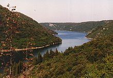
The Istrian peninsula consists largely of limestone . The coast is deeply indented, some inlets such as the Limski Canal (between Vrsar and Rovinj ) or the Plomin-Fianona bay extend deep into the interior and have a fjord-like character. The beaches are mostly pebble or rocky beaches. Sandy beaches are very rare in all of Istria. B. in Medulin. Tourism on the coast is important and has a tradition that goes back to the 19th century. The highest point in Istria is Mount Vojak (1401 m) in the Učka Mountains .
The economic center and largest city in Istria is the port city of Pula . Well-known seaside resorts are Medulin , Rovinj , Poreč , Ičići , Lovran , Medveja , Mošćenička Draga , Opatija and Umag in the Croatian and Koper , Portorož , Piran and Izola in the Slovenian part; Muggia and San Dorligo della Valle in Italy.
In the northern and central part of Istria, the places are mostly on prominent hills, which gives the landscape a special charm. Inner Istria is very sparsely populated. The most important places here are Motovun , Buzet , Buje and Grožnjan , which is best known for its artists' colony and music performances. The population lives from tourism, which has traditionally existed for decades, from agriculture and works in local industrial companies. Wine-growing is practiced intensively in these regions, especially the yellow to greenish, slightly bitter Malvazija and the light red Teran are pressed. In the area around Motovun excellent truffles are found, which some connoisseurs consider to be among the best in the world. The Kaiserling ( Amanita caesarea ) is also one of the Istrian mushroom specialties.
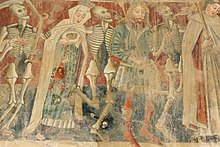
The interior of Istria is rich in remarkable architectural monuments. Often there are small, inconspicuous churches that impress with mostly well-preserved frescoes. The best known is the Marienkirche in Beram with a grandiose dance of death cycle . In the fields you can occasionally find very old kažuns - stone huts that were built by farmers and shepherds in earlier times.
The southern tip of the peninsula forms the nature reserve Cape Kamenjak ( Capo Promontore-Rt Kamenjak or Donji Kamenjak ) with its unique flora and fauna.
The coastline of the western Croatian region of Istria is 537 kilometers. On some sections of the rocky coast, including near Rovinj and in the Brijuni National Park , fossilized dinosaur footprints can be found right on the beach.
geology
The geological conditions in Istria are mainly characterized by limestones, dolomites and sand and marl stones . On the entire peninsula, the landscapes show karst phenomena of varying degrees. They represent a southerly continuation of these structures beginning in the Trieste Karst.
In addition to a few Quaternary sediments in the north ( Mirna Valley) and in the east ( Raška Draga ) , the surface is only formed from rocks from the Paleogene , Cretaceous and Upper Jurassic . The Jurassic deposits are the oldest areas of Istria, but form only a smaller zone on the west coast between the cities of Poreč and Rovinj . The sediments of the Lower Cretaceous lie concordantly on the Jura formations and make up most of Istria. It is followed by paleogenic deposits in almost the same area.
According to the different soils, Istria is divided into a white, a gray and a red region. These three areas are also the three elevation and landscape zones of the Istrian peninsula.
The white color corresponds to the highest parts in the east of the peninsula, which is caused by the almost bare limestone rock. Mainly these are the Ćićarija and Učka mountain ranges . This karst region is also known as the Tschitschenkarst (formerly Tschitschenboden ), the name of which was derived from the Romanian- speaking inhabitants of Tschitschen .
The central part of Istria has a lot of clay soils and is called gray Istria because of its color . This hilly country is considerably rugged, very dry, only sparsely populated and characterized by flysch deposits . The formative rocks here are sandstones, marl rocks and occasional breccias .
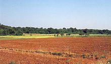
A limestone plateau with terra rossa floors extends between the central part and the western coastal zone . These red soils gave this part of the country the name Red Istria . Only a few gorges cut into this plateau with an altitude between 200 and 400 meters. The largest gullies are the Limska Draga and the Mirna Valley from the western coast and the Raška Draga to the east, all of which correspond with tectonic lines. In this zone there are deposits of very dense limestone, which has been used for building stones and sculpting purposes at least since the Roman era. The architectural evidence of the Romans in Pula was mainly built from Istrian limestone (e.g. the amphitheater ). The Vinkuran quarry near Pula is therefore also known as the cava romana . In particular, the quarrying sites on the west coast provided building material for Venice over long periods of time. Later they were used in the entire territory of the Austro-Hungarian Monarchy and were used under the collective term karst marbles in competition with the stone from the area around Trieste . The extensive Terra rossa deposits formed the basis of brick production that had been going on since Roman times.
The Austro-Hungarian geologist Guido Stache made a special contribution to the geological exploration of Istria . He was responsible for early comprehensive work from this region and first coherent ideas about its geological structure. They were created during his field work and subsequent publications between 1858 and 1888.
climate
With 2,380 hours of sunshine annually, Istria has a very favorable climate: in summer it usually doesn't get too hot, while winters are mild. The coldest month is statistically February with an average of 6 ° C and the warmest month is July with an average of 24 ° C. The annual average is 14 ° C.
traffic
The main roads are the A8 and A9 motorways of the Istrian Ypsilon . The A9 connects Pula with the Slovenian border. The junction to the eastbound A8 is near Kanfanar . There is also a main road near the coast and a branching network of smaller roads.
The rail network comes almost exclusively from the old Austrian era. The main connection was put into operation in 1876 as the Istrian State Railroad and runs from Pula in a north direction through all of Istria to the connection to the Slovenian railway network and to Ljubljana . From there there are direct connections to Austria and Germany.
The 18-kilometer rail link from Kozina to Trieste was closed in 1960 due to the demarcation of the border between Italy and Yugoslavia, but according to current reports it may be restored. There is currently a cycle path on the former route. There are bus connections from Trieste Centrale to the train station in Koper and the train station in Hrpelje-Kozina. Until 1935 there was also the narrow-gauge connection Trieste - Parenzo (today Poreč), often also called Parenzana .
A rail connection to the actual Croatian railway network never existed, but was considered at times after Croatia's independence.
There are international airports near Pula, Rijeka ( Croatia ) and Portorož ( Slovenia ) . The Rijeka Airport is, among others, so-called since 2005. Low cost airlines fly. The Pula airport is also available for take-offs and landings of the Boeing 747 designed (Jumbo Jet).
history
Prehistory and Antiquity
The existence of man in the area of Istria during the Paleolithic is proven by finds in the Romuald Cave in the Limer Canal. The second site is Šandalja near Pula, where human remains were found 12,000 years ago.
From the younger Stone Age around 6000 BC. The oldest pottery found in the caves on the islands of Cres, Lošinj and Krk comes from the 4th century and is characterized by its characteristic ornamentation, which was made by impressing with the edges of a shell or other objects ( cardial or imprint culture ). One of the oldest documented settlements in Istria, today's Premantura , dates back to the Bronze Age . The peninsula was until about 2000 BC. Sparsely populated BC, the few inhabitants lived in small hamlets on the coast or in the hinterland, where there was access to water. Thereafter, Istria was covered by a network of residential areas, the previously unused hills settled. This is where the so-called gradines or castellieri emerged, early urban squares secured by enormous stone walls. There is evidence of larger central locations that were surrounded by smaller ones, while secondary settlements were apparently subordinate to main settlements. A kind of land expansion caused the oak stocks to decrease drastically, instead extensive fields were created on red earth soils, extensive pasture zones and even vineyards. The strong and rapid increase in population density and number indicates a high level of immigration. The origin of the immigrants cannot yet be identified. In any case, the immigration took place in an environment of increasing density of trade, which is indicated by the use of bread loafs , which can possibly be interpreted as a kind of register of quantities of goods, and thus as a very simple form of written expression. Monkodonja was founded between 1800 and 1200 BC. Inhabited by a population whose culture reveals influences of the Mycenaean culture of Greece.
In ancient times the peninsula was known as Histria . Their inhabitants, the Histrians, are considered by research to be related to either the Veneters or the Liburnians . The Romans got to know the inhabitants as daring pirates . One of the most important cities in pre-Roman times was Nesactium . The remains of a gate and fortifications have been preserved from this period, as well as a necropolis with over 250 graves. Nesactium maintained trade relations as far as Greece, with the Etruscans and as far as the Alpine region. Under King Epulo they defended until 177 BC. The city against the Romans, who destroyed Nesactium after the conquest.
The Romans launched their first war campaign to Istria in 221 BC. After they incorporated neighboring Veneto into their empire. There were renewed clashes between the Romans and the Histri, when the first came in 181 BC. Founded the colony Aquileia . Despite intense resistance, the Romans managed to capture Istria by 178 BC. To conquer completely. Up until the time of Caesar, Istria belonged to the Roman Illyricum, which was not yet fully organized as a province.
Under Augustus and Tiberius , Istria became a region and together with Veneto formed the so-called 10th Region Venetia et Histria . All free residents of Istria have been Roman citizens since then. Significant architectural evidence from Roman times has been preserved in Pula ( Augustus Temple (Pula) , Pula amphitheater ). Archaeological traces can be found in Nesactium.
See also: Histrier
middle Ages
The Romanesque element persisted throughout Istria. The Lombards were added to the north in 568. The invading Slavs on the eastern border above the Cicciaria devastated parts of Istria, but were unable to take it and were repulsed by the exarchs of Ravenna, especially during the Balkan campaigns of Maurikios by Kallinikos .
Alpine novels in Istria and Slavic conquest in Liburnia
The Alpine Romans settled in Istria as well as in Friuli . The furthest western advance of the Slavs ( Croats , Slovenes ) advancing in the late late antiquity, in the 6th century, across the lower Danube (abandoned by the Visigoths in the 5th century) was the eastern border of Istria, the so-called Cicciaria. The Slavs undertook raids between the Eastern Roman provinces of Pannonia and Dalmatia (important information on this is also provided by the Chronicle of Monemvasia ) and partly in Istria.
Under the Franconian Empire (788 / 91-804)
In 788, at the latest in 791, Pippin , son of Charlemagne , subjugated Istria to the Frankish Empire. In 803 the peninsula was incorporated into the Friuli region . In 827 the Patriarchate of Aquileia received metropolitan power over Istria and its bishopric. In 828/829 the Friuli march of the former Lombard duchy was divided into four counties. From this point on, Istria and the county of Friuli formed the Aquileia region .
High Middle Ages

Otto I. awarded the Mark Aquileia (together with the Mark Verona ) to Bavaria from 952 ; from 976 the Mark Aquileia came to Carinthia . 1040 was Istria by Henry III. transformed into a separate margravate of the Holy Roman Empire , separated from Friuli .
With this margraviate, which also ran under the name Meranien , various noble families were enfeoffed successively from 1040 to 1208, so from 1090 the Spanheimers and finally from 1170 the Counts of Andechs , called Andechs-Meranien . The first of them was Count Berthold V , who was also titular duke of Dalmatia (Merania, Meran). He was followed in 1188 by his son Berthold VI. and in 1204 his fourth son, Margrave Heinrich of Istria. The latter was blamed for participation in the assassination of King Philip in 1208/09 , he lost a. a. the margraviate and had to go into temporary exile.
The later Emperor Otto IV handed the mark to Duke Ludwig of Bavaria in 1208 . This ceded it to the Patriarch of Aquileia , Wolfger von Erla , who made a claim.
Since the Andechs-Meranians practically never resided in Istria, relatively independent property complexes of the Patriarchate of Aquileia , the local bishops, Venetian monasteries, the Ravenna episcopal church of Sant'Apollinare, the dynasty of Duino (near Trieste) and the Counts of Gorizia (Gorizia ) out. In addition, Venice tried, initially successfully, to gain control over the coastal cities. However, its influence was pushed back in the first half of the 13th century by the Patriarchs of Aquileia.
In the second half of this century, however, when the empire was weakened after the end of the Staufer dynasty, Venice was able to regain influence at the expense of the Patriarchate of Aquileia. At the same time, the Counts of Gorizia expanded their influence in the interior of the peninsula - also at the expense of Aquileia. In the Peace of Treviso in 1291, the Republic of Venice finally received sovereignty over the coast from Koper (Capodistra) to Rovinj (Rovigno) and the Counts of Gorizia over the karst areas in the interior. Pola, which had made itself independent, came under Venetian rule only in 1331. Trieste could keep itself independent even longer; in 1382 it submitted to the protectorate of the Habsburgs . In 1374 , the territories in the interior ( Grafschaft Mitterburg ) acquired by the Counts of Görz from around 1200 fell to these new masters by inheritance .
Early modern age
Venetian and Habsburg
Venetian Istria, which mainly comprised the coastal areas, remained under Venetian rule for four hundred years . The clearly recognizable Venetian flair of the coastal towns of Istria also dates from this time. Venetian Istria included Monfalcone , Grado , Koper ( Capo d'Istria ), Pula ( Pola ), Poreč ( Parenzo ), Rovinj ( Rovigno ), Umag ( Umago ), Labin ( Albona ) and other cities.
Time of the coalition wars

After the Peace of Campo Formio in 1797, Austria occupied the country. But when it renounced all “Venetian possessions” in the Peace of Pressburg in 1805 , Istria also had to cede to France . Istria was added to the Kingdom of Italy . From this and from some other areas the department of Istria was formed (2,900 km² with 82,300 inhabitants, capital Koper / Capo d'Istria). In 1808 Napoleon I appointed Marshal Jean-Baptiste Bessières "Duke of Istria". Later, Napoleon united Istria with the Illyrian provinces . In 1813 the two areas were recaptured by the Austrians. From 1815, Istria again formed part of the Austrian monarchy and became part of the Kingdom of Illyria .
Empire of Austria and Austria-Hungary
In 1849 the Kingdom of Illyria was dissolved. Istria now formed with Trieste and its surrounding area as well as with Gorizia and Gradisca the Crown Land of the Austrian Coastal Region (Litorale) with an Imperial and Royal governor in Trieste.
With the imperial constitution of 1861, the three constituent parts of the coastal land acquired their status as independent crown lands with a state parliament, state committee and governor appointed by the emperor, but the common imperial governor for the Austro-Irish coastal land in Trieste and the common state law gazette (not common laws, only joint publication) received until 1918.
Istrian self-government was now taken care of by the state parliament and the regional committee based in Poreč / Parenzo. Due to the census suffrage, which was limited to men, and a constituency that favored the municipalities of the west coast, Italian-speaking Istrians obtained a majority of the MPs in the elections , albeit on different lists, until 1918. Accordingly, in the monarchy the place names in Istria were always officially mentioned in their Italian version.
According to the 1846 census, the margravate of Istria had 228,035 inhabitants, including 134,445 Croats (59%), 60,000 Italians (26%) and 31,995 Slovenes (14%). The details of this survey are, however, imprecise. They served as the basis for the ethnographic map of the Austrian monarchy by Karl Freiherr von Czoernig (1855). In Pola (Pula) of the main naval port was located since 1867 Imperial and Royal Navy . The crown land, which also comprised the islands of the Quarnero, the Kvarner Bay, had in 1900 an area of 4,955 km² with 345,000 inhabitants.
Administrative division of the Margraviate of Istria (1868–1918)
- Districts
- Judicial districts
According to the 1910 census, Austrian Istria had 386,463 inhabitants, including 168,184 Croats (43%), 147,417 Italians (38%), 55,134 Slovenes (14%) and 15,728 others (4%). Austrian Istria, however, included Liburnia and the Karst , where there was a Slavic majority. However, these regions do not belong to today's Istria. In this respect, these statistics cannot be compared with later ones.
20th century
Italy
In the London Treaty of April 26, 1915, territorial promises were made to Italy , including with regard to Istria, in order to persuade it to enter the war on the side of the Allies. The majority of the inhabitants of both Istria and Trieste were Italians. The treaty played an important role in the history of Istria insofar as the irredentist Italian diplomacy in the circle of the Big Four repeatedly and increasingly persistently invoked this treaty in the peace negotiations in order to enforce Italy's territorial claims. According to the London Treaty, in addition to Gorizia and Gradisca, Istria with Trieste and the Dalmatian islands should also fall to Italy.
With the Treaty of Saint-Germain in 1919 after the First World War , all of Istria came to Italy as part of the Julian Veneto region . The Rapallo border treaty in 1920 confirmed this bilaterally between Italy and the newly founded state of Yugoslavia . Thus, within the borders of the Kingdom of Italy, a sizeable Slavic minority of Slovenes and Croats emerged .
On March 2, 1921, the Labin miners went on strike because of poor working conditions. After 36 days this was violently ended and the leaders responsible were punished. This episode went down in history as the Labin Republic (Labinska Republika).
Second World War
During the Second World War , Italians fought together with Croatian and Slovenian partisans against Italian fascism . After Italy changed the front to the side of the Allies in 1943, the partisans initially took control, but Istria and the neighboring areas were immediately occupied by the German Wehrmacht . Istria was placed under German occupation as the Adriatic Coastal Operation Zone , which lasted until the spring of 1945. As a result, as in 1943, reprisals and massacres of the Italian civilian population by the partisan organizations took place. The Yugoslav communists took collective revenge on the Italians : Between 5,000 and 21,000 people fell victim to the Foibe massacres .
Between 200,000 and 350,000 Italian-Venetian Istrians left Istria as expellees / optants ( Esuli ) after 1945 in the course of the repression by the Tito regime. This repression and expulsion effectively led to the extinction of the old Venetian-Istrian culture of the Italian-speaking ethnic group.
Trieste Free Territory
When the second Yugoslavia was founded in 1945, the main part came to the Republic of Croatia, the northwestern part of Istria initially belonged to the territory of the Free Territory of Trieste . When in 1954 the area of the Free Territory was divided between Yugoslavia and Italy, the Yugoslav part was in turn divided between the republics of Slovenia and Croatia. Numerous Italian optants (according to the Yugoslav / Croatian interpretation) or Esuli (German " exiles " or "exiles") moved to Italy after the establishment of the Socialist Federal Republic of Yugoslavia and as a result of cruel reprisals. Due to ethnic discrimination and in the course of systematic murders, deportations and displacement (see also: AVNOJ resolutions and Foibe massacres ), 90% of the Italian population of Istria emigrated. The area around the cities of Capodistria and Portorose came to Slovenia, the area further south from Parenzo to Pola to Croatia. The border between Italy and Yugoslavia was finally laid down in the Treaty of Osimo in 1975 . The agreement for the protection of minorities on both sides of the border, which was concluded at the same time, guaranteed the rights of the Italian minority on Yugoslav (or today, as legal successors, Croatian and Slovenian) territory. Bilingual place-name signs and street names today mark the multicultural Istria in the Slovenian and Croatian parts, while at best bilingual signposts can be found in and around Trieste.
The question of the expropriation of the homes and property of the former Italian population in around 1,000 Istrian villages and towns of today's Slovenia and Croatia by the communist Tito regime without compensation has not yet been resolved.
Disintegration of Yugoslavia
In contrast to the border with Italy, the border between the republics of Croatia and Slovenia in northwestern Istria was relatively imprecise in a few places during the Yugoslav period. After the independence of the two states in 1991/92, a controversy arose between the two states about the exact course of the border in a few places, especially about the maritime border in the Gulf of Trieste, which has not yet been finally resolved . The negotiations are still ongoing (see: International Conflicts in the Successor States of Yugoslavia ). Istria, which was not directly affected by the bloody war events, took in tens of thousands of compatriots from Slavonia , Dalmatia and Lika in hotels and campsites during the war years (1991–1995) .
Croatian part of Istria
In both countries there is bilingual education. Croatian - Italian (e.g. Croatian Pula / Italian Pola) or Slovenian- Italian (e.g. Slovene Koper / Italian Capodistria) can also be found in street and place names .
The Croatian and larger part of Istria (89% of the peninsula) is subject to the Istria County (Croat. Istarska županija). The main administrative seat is in Pazin-Pisino-Mitterburg . The economic and cultural center, however, is Pula / Pola (57.053 inhabitants, 2012). About 76% of the population in Istria County are Croatians . The County of Istria is divided into 10 cities and 31 municipalities and borders on the Croatian County Primorje-Gorski kotar ( Kvarner / Rijeka ) and the neighboring country Slovenia. It has an area of 2,813 km² and is one of the larger 21 Croatian counties. Along with Dalmatia and the Kvarner region, Istria is one of the most visited regions in Croatia. In addition to the largest city Pula / Pola , Umag / Umago , Porec / Parenzo , Rovigno / Rovinj , Porto d'Albona / Rabac and Abbazia / Opatija are popular travel destinations for national and international tourists. In front of Istria there are also the Brioni Islands, off the west coast, and the island of Cres , on the east coast of the peninsula.
Composition of the population in the Croatian part of Istria by nationality according to the 2001 census:
| Ethnicity | number | percent |
|---|---|---|
| Croatians | 148,328 | 71.88% |
| Italian | 14,284 | 6.92% |
| Serbs | 6,613 | 3.20% |
| Bosniaks | 3,077 | 1.49% |
| Albanians | 2,032 | 0.98% |
| Slovenes | 2,020 | 0.98% |
| Declaration in terms of regional affiliation * | 8,865 | 4.30% |
The regionally declared is not a nationality in the legal sense, but a regional population.
| local community | Italian name | Country | Pop. | Italo-phon | Slav-phon |
|---|---|---|---|---|---|
| Labin | Albona | Croatia | 12,426 | 3.09% | 92.62% |
| Buje | Buie d'Istria | Croatia | 5,340 | 39.66% | 53.76% |
| Novigrad | Cittanova d'Istria | Croatia | 4,002 | 15.32% | 77.59% |
| Vodnjan | Dignano | Croatia | 5,651 | 19.93% | 73.16% |
| Poreč | Parenzo | Croatia | 17,460 | 6.42% | 87.12% |
| Buzet | Penguins | Croatia | 6,059 | 0.87% | 96.63% |
| Pazin | Pisino | Croatia | 9.227 | 1.21% | 97.56% |
| Pula | Pola | Croatia | 58,594 | 4.87% | 88.38% |
| Rovinj | Rovigno | Croatia | 14,234 | 10.81% | 81.85% |
| Umag | Umago | Croatia | 12,901 | 20.70% | 72.87% |
| Bale | Valle | Croatia | 1,047 | 22.54% | 75.36% |
| Barban | Barbana d'Istria | Croatia | 2,802 | 0.39% | 99.21% |
| Brtonigla | Verteneglio | Croatia | 1,579 | 41.29% | 52.83% |
| Cerovlje | Cerreto | Croatia | 1,745 | 0.46% | 99.31% |
| Fažana | Fasana | Croatia | 3,050 | 4.66% | 90.75% |
| Gračišće | Gallignana | Croatia | 1,433 | 0.28% | 99.16% |
| Grožnjan | Grisignana | Croatia | 785 | 66.11% | 29.17% |
| Kanfanar | Canfanaro | Croatia | 1,457 | 1.51% | 96.23% |
| Karojba | Caroiba del Subiente | Croatia | 1,489 | 0.94% | 97.99% |
| Kaštelir-Labinci | Castellier Santa Domenica | Croatia | 1,334 | 7.80% | 88.23% |
| Kršan | Chersano | Croatia | 3,264 | 0.40% | 94.49% |
| Lanišće | Lanischie | Croatia | 398 | np. | 98.99% |
| Ližnjan | Lisignano | Croatia | 2,945 | 8.05% | 88.29% |
| Lupoglav | Lupogliano | Croatia | 929 | 0.32% | 98.82% |
| Marčana | Marzana | Croatia | 3,903 | 0.74% | 97.72% |
| Medulin | Medolino | Croatia | 6.004 | 3.05% | 89.77% |
| Motovun | Montona | Croatia | 983 | 15.46% | 81.28% |
| Oprtalj | Portole d'Istria | Croatia | 981 | 32.11% | 65.04% |
| Pićan | Pedena | Croatia | 1.997 | 0.95% | 98.05% |
| Raša | Arsia | Croatia | 3,535 | 2.63% | 94.29% |
| Sveta Nedelja | Santa Domenica d'Albona | Croatia | 2,909 | 1.51% | 97.32% |
| Sveti Lovreč | San Lorenzo del Pasenatico | Croatia | 1,408 | 1.49% | 96.38% |
| Sveti Petar and Šumi | San Pietro in Selve | Croatia | 1.011 | 0.30% | 99.21% |
| Svetvinčenat | Sanvincenti | Croatia | 2,218 | 1.17% | 97.16% |
| Tinjan | Antignana | Croatia | 1,770 | 0.79% | 98.59% |
| Višnjan | Visignano | Croatia | 2,187 | 8.78% | 89.44% |
| Vižinada | Visinada | Croatia | 1,137 | 8.36% | 90.59% |
| Vrsar | Orsera | Croatia | 2,703 | 2.96% | 90.75% |
| Žminj | Gimino | Croatia | 3,447 | 1.28% | 97.80% |
| Twill | Capodistria | Slovenia | 47,539 | 2.20% | np |
| Izola | Isola | Slovenia | 14,549 | 4.30% | np |
| Piran | Pirano | Slovenia | 16,758 | 7.00% | np |
| Lovran | Laurana | Croatia | 3,987 | 1.71% | 92.65% |
| Mošćenička Draga | Draga di Moscenica | Croatia | 1,641 | 0.91% | 95.67% |
| Opatija | Abbazia | Croatia | 12,719 | 4.64% | 93.81% |
Slovenian part of Istria
The Slovenian Adriatic coast measures 46 km from the Italian border Ankaran to the Croatian border in the Dragonja Valley. This part is now part of the Primorska region on the Slovenian coast. The economic and cultural center is Koper (50,000 inhabitants), about 20 km south of Trieste (Slovenian / Croatian Trst) in Italy.
See also
swell
- Pietro Kandler : Codice diplomatico istriano , 5 volumes, Trieste 1862–1865 (covers the years 50–1194, 1200–1299, 1300–1399, 1400–1499 and 1500–1526) ( link to digital copies )
- Nicolò Manzuoli: Nova descrittione della provincia dell'Istria di Nicolo Manzvoli Dottor di Legge. Con la vita delli santi, et sante di detta Prouincia , Giorgio Bizzardo, Venice 1611 (contains vitae of saints, a description of the country and a historical overview, up to p. 78). ( Digitized version )
literature
- Harald Waitzbauer : Through Istria. With the Istrian State Railroad to the kk Adriatic Province , Salzburg 1989. ISBN 3-7013-0757-1
- Hans-Dieter Kaspar, Elke Kaspar: Istria. An archaeological journey of discovery , Korient, Schonungen 2005. ISBN 3-925696-18-0
- Peter Štih: Istria at the onset of the Frankish Rule, or the impact of global politics on regional and local conditions , in: Mladen Ančić, Jonathan Shepard, Trpimir Vedriš (eds.): The Middle Ages between the Eastern Alps and the Northern Adriatic . Select Papers on Slovene Historiography and Medieval History , Brill, 2010, pp. 212-229.
- Peter Štih: Imperial politics and its regional consequences. Istria between Byzantium and the Franks 788-812 , in: Mladen Ančić, Jonathan Shepard, Trpimir Vedriš (eds.): Imperial Spheres and the Adriatic. Byzantium, the Carolingians and the Treaty of Aachen (812) , Routledge, 2018, pp. 57-72. ( academia.edu )
Web links
Individual evidence
- ↑ Dmitar Čulić: Istria and Kvarner, Beograd (Jugoslavija Publishing House) 1963
- ↑ Dubravko Matičec: Neotectonic deformation in Western Istria, Croatia . In: Geologia Croatica 47/2 Zagreb (Institute of Geology) 1994
- ↑ G. Steinmann / O. Wilckens (ed.): Handbook of Regional Geology. Balkan Peninsula. The coastal countries of Austria-Hungary . Heidelberg (Winter University Bookstore) 1914
- ↑ Guido Stache: Geological landscape of the Istrian coastal land. Vienna 1864
- ^ Stefan Mlakar: The Romans in Istria . Pula 1966
- ↑ Climate table from istrien-virtuell.de
- ^ Siegmar von Schnurbein (ed.): Atlas of the prehistory. Europe from the first humans to the birth of Christ , Theiss, Stuttgart 2009, 2nd, improved edition, Theiss, Stuttgart 2010, pp. 123–125.
- ↑ Peter Štih: Istria at the onset of the Frankish Rule, or the impact of global politics on regional and local conditions , in: Mladen Ančić, Jonathan Shepard, Trpimir Vedriš (eds.): The Middle Ages between the Eastern Alps and the Northern Adriatic. Select Papers on Slovene Historiography and Medieval History , Brill, 2010, p. 212.
- ↑ Land ordinance and Landtag election ordinance, Appendix II i to the Imperial Constitution 1861, RGBl. No. 20/1861 (= p. 69, supplement: p. 198)
- ↑ Historical legal texts on the website of the Austrian National Library
- ↑ Frank Wiggermann: Kuk Kriegsmarine und Politik: a contribution to the history of the Italian national movement in Istria , Verlag der Österreichischen Akademie der Wissenschaften, Vienna 2004 (studies on the history of the Austro-Hungarian monarchy, vol. 28), zugl .: Westfälische Wilhelms-Universität , Dissertation, Münster in Westphalia 2000, ISBN 3-7001-3209-3
- ↑ 2001 census , Croatian State Statistical Office, dzs.hr

