| place
|
church
|
construction time
|
image
|
Geographic coordinates
|
|
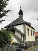
Achelstädt
|
ev. church
|
1857
|

|
! 550.8361115511.121389550 ° 50 '10.0 " N , 011 ° 07' 17.0" E50.836111111111 11.121388888889
|
|
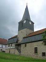
Alkersleben
|
St. Gregorius village church
|
15th century
|
|
! 550.8450005511.042778550 ° 50 '42.0 " N , 011 ° 02' 34.0" E50.845 11.042777777778
|
|
Altenfeld
|
ev. church
|
1741
|

|
! 550.5647225510.959444550 ° 33 '53.0 " N , 010 ° 57' 34.0" O50.564722222222 10.959444444444
|
|
Angelhausen
|
ev. Johanneskirche
|
12th century
|
|
! 550.8258335510.967778550 ° 49 '33.0 " N , 010 ° 58' 04.0" E50.825833333333 10.967777777778
|
|
Angelroda
|
ev. church
|
15th century
|

|
! 550.7452785510.866389550 ° 44 '43.0 " N , 010 ° 51' 59.0" O50.745277777778 10.866388888889
|
|
Arnstadt
|
ev. ev. Bach church
|
1687
|

|
! 550.8341675510.946389550 ° 50 '03.0 " N , 010 ° 56' 47.0" O50.834166666667 10.946388888889
|
| Arnstadt
|
cath. Elisabeth Church
|
1877
|

|
! 550.8375005510.943889550 ° 50 '15.0 " N , 010 ° 56' 38.0" O50.8375 10.943888888889
|
| Arnstadt
|
cath. Assumption Church
|
1743
|

|
! 550.8369445510.947778550 ° 50 '13.0 " N , 010 ° 56' 52.0" O50.836944444444 10.947777777778
|
| Arnstadt
|
ev. Liebfrauenkirche
|
12th century
|
|
! 550.8333335510.941667550 ° 50 '00.0 " N , 010 ° 56' 30.0" O50.833333333333 10.941666666667
|
|
Arnstadt
|
ev. upper church
|
13th century
|
|
! 550.8325005510.945833550 ° 49 '57.0 " N , 010 ° 56' 45.0" O50.8325 10.945833333333
|
|
Bechstedt-Wagd
|
ev. Trinity Church
|
1724
|

|
50 ° 54 '20 " N , 11 ° 3' 50" E50.905555555556 11.063888888889
|
|
Behringen / Ilm
|
ev. church
|
1717
|
|
! 550.7733335511.013333550 ° 46 '24.0 " N , 011 ° 00' 48.0" E50.773333333333 11.013333333333
|
|
Bittstädt
|
ev. Aegidia Church
|
|
|
! 550.8358335510.888333550 ° 50 '09.0 " N , 010 ° 53' 18.0" O50.835833333333 10.888333333333
|
|
Bohlen
|
ev. Anne's Church
|
1822
|

|
! 550.5863895511.041389550 ° 35 '11.0 " N , 011 ° 02' 29.0" E50.586388888889 11.041388888889
|
|
Evil life
|
ev. church
|
1893
|

|
! 550.8255565511.060556550 ° 49 '32.0 " N , 011 ° 03' 38.0" E50.825555555556 11.060555555556
|
|
Branchewinda
|
ev. Church of St. James the Elder
|
12th century
|

|
! 550.7866675510.993056550 ° 47 '12.0 " N , 010 ° 59' 35.0" O50.786666666667 10.993055555556
|
|
Bücheloh
|
ev. church
|
12th century
|

|
! 550.7108335510.974722550 ° 42 '39.0 " N , 010 ° 58' 29.0" E50.710833333333 10.974722222222
|
|
Cottendorf
|
ev. church
|
17th century
|

|
! 550.7347225511.026111550 ° 44'05.0 " N , 011 ° 01'34.0" E50.734722222222 11.026111111111
|
|
Dannheim
|
ev. Bonifatiuskirche
|
1777
|

|
! 550.7958995510.976758550 ° 47 '45.2 " N , 010 ° 58' 36.3" E50.795899134444 10.976758003333
|
|
Dienstedt
|
ev. church
|
13th century
|

|
! 550.8011115511.171389550 ° 48 '04.0 " N , 011 ° 10' 17.0" O50.801111111111 11.171388888889
|
|
Dollstedt
|
ev. church
|
1870
|

|
! 550.7644445511.141389550 ° 45 ′ 52.0 ″ N , 011 ° 08 ′ 29.0 ″ E50.764444444444 11.141388888889
|
|
Dörnfeld on the Ilm
|
ev. church
|
1902
|

|
! 550.7349175511.035556550 ° 44 '05.7 " N , 011 ° 02' 08.0" O50.734916666667 11.035555555556
|
|
Dornheim
|
ev. St. Bartholomäi Church
|
12th century
|

|
50 ° 50 ′ 6 " N , 10 ° 59 ′ 29" E50.835 10.991388888889
|
|
Dosdorf
|
ev. Otmarkirche
|
16th century
|

|
! 550.7978615510.914639550 ° 47 '52.3 " N , 010 ° 54' 52.7" E50.797861111111 10.914638888889
|
|
Ehrenstein
|
ev. church
|
1730
|
|
! 550.7573615511.173528550 ° 45 '26.5 " N , 011 ° 10' 24.7" O50.757361111111 11.173527777778
|
|
Eischleben
|
ev. Matthias Church
|
1744
|

|
50 ° 53 '15.3 " N , 10 ° 59' 24.8" E50.887593696389 10.990228056944
|
|
Elgersburg
|
ev. Nikolauskirche
|
1586
|
|
! 550.7018615510.853917550 ° 42 '06.7 " N , 010 ° 51' 14.1" O50.701861111111 10.853916666667
|
|
Elleben
|
ev. church
|
1729
|

|
! 550.8623895511.092222550 ° 51 '44.6 " N , 011 ° 05" 32.0 " E50.862388888889 11.092222222222
|
|
Ellichleben
|
ev. Peace-of-God-Church
|
1720
|

|
! 550.8156395511.134917550 ° 48 '56.3 " N , 011 ° 08' 05.7" O50.815638888889 11.134916666667
|
|
Elxleben
|
ev. Peter and Paul Church
|
1725
|

|
! 550.8666675511.057139550 ° 52 '00.0 " N , 011 ° 03' 25.7" E50.866666666667 11.057138888889
|
|
Aspenfield
|
ev. Cruciskirche
|
12th century
|

|
50 ° 48 '37.6 " N , 10 ° 53' 36.5" E50.810458333333 10.893469444444
|
|
Et table life
|
ev. Cyriakuskirche
|
12th century
|

|
! 550.8388335511.034583550 ° 50 ′ 19.8 ″ N , 011 ° 02 ′ 04.5 ″ E50.838833333333 11.034583333333
|
|
Frankenhain
|
ev. church
|
1722
|

|
! 550.7573615510.790139550 ° 45 '26.5 " N , 010 ° 47' 24.5" O50.757361111111 10.790138888889
|
|
Frauenwald
|
Schinkel Church of St. Nicolai
|
1833
|

|
! 550.5811675510.859583550 ° 34 '52.2 " N , 010 ° 51' 34.5" E50.581166666667 10.859583333333
|
|
Miter
|
ev. Michaeliskirche
|
1834
|

|
! 550.6488335511.003250550 ° 38 '55.8 " N , 011 ° 00' 11.7" E50.648833333333 11.00325
|
|
Geilsdorf
|
ev. church
|
1882
|

|
! 550.7436675511.081167550 ° 44 '37.2 " N , 011 ° 04'52.2" E50.743666666667 11.081166666667
|
|
Geraberg
|
ev. Bartholomäuskirche
|
1753
|
|
! 550.7172785510.847361550 ° 43 '02.2 " N , 010 ° 50' 50.5" E50.717277777778 10.847361111111
|
|
Geschwenda
|
ev. Nikolaikirche
|
1748
|
|
! 550.7309445510.825333550 ° 43 '51.4 " N , 010 ° 49' 31.2" E50.730944444444 10.825333333333
|
|
Gillersdorf
|
ev. church
|
1829
|

|
! 550.6070565511.017889550 ° 36 '25.4 " N , 011 ° 01'04.4" E50.607055555556 11.017888888889
|
|
Goerbitzhausen
|
ev. Johanneskirche
|
15th century
|

|
! 550.7935005511.010500550 ° 47 '36.6 " N , 011 ° 00' 37.8" E50.7935 11.0105
|
|
Gossel
|
ev. church
|
|
|
! 550.7984725510.850444550 ° 47 '54.5 " N , 010 ° 51' 01.6" E50.798472222222 10.850444444444
|
|
Gösselborn
|
ev. Nikolaikirche
|
1688
|

|
50 ° 43 '44 " N , 11 ° 4' 58" E50.728888888889 11.082777777778
|
|
Graefenroda
|
ev. Laurentiuskirche
|
1733
|

|
! 550.7500005510.812222550 ° 45 '00.0 " N , 010 ° 48' 44.0" O50.75 10.812222222222
|
|
Gräfinau-Angstedt
|
ev. All Saints Church
|
1831
|

|
! 550.6991675511.021000550 ° 41 ′ 57.0 ″ N , 011 ° 01 ′ 15.6 ″ E50.699166666667 11021
|
|
Griesheim
|
ev. church
|
17th century
|

|
! 550.7527785511.039861550 ° 45 ′ 10.0 ″ N , 011 ° 02 ′ 23.5 ″ E50.752777777778 11.039861111111
|
|
Großbreitenbach
|
ev. Trinity Church
|
1690
|

|
! 550.5843615511.015944550 ° 35 '03.7 " N , 011 ° 00' 57.4" O50.584361111111 11.015944444444
|
|
Grosshettstedt
|
ev. church
|
1840
|

|
! 550.7913615511.136222550 ° 47 '28.9 " N , 011 ° 08' 10.4" E50.791361111111 11.136222222222
|
|
Grandchildren
|
ev. church
|
1900
|

|
! 550.7536115511.124222550 ° 45 ′ 13.0 ″ N , 011 ° 07 ′ 27.2 ″ E50.753611111111 11.124222222222
|
|
Gügleben
|
ev. Gangolf Church
|
1697
|

|
! 550.8807225511.085139550 ° 52 '50.6 " N , 011 ° 05" 06.5 " E50.880722222222 11.085138888889
|
|
Haarhausen
|
ev. Nikolauskirche
|
1184
|

|
! 550.8636115510.898611550 ° 51 '49.0 " N , 010 ° 53' 55.0" O50.863611111111 10.898611111111
|
|
Hausen
|
ev. Nikolauskirche
|
12th century
|

|
! 550.8086675511.010889550 ° 48 '31.2 " N , 011 ° 00' 39.2" E50.808666666667 11.010888888889
|
|
Herschdorf
|
ev. church
|
1691
|

|
! 550.6285005511.048750550 ° 37 '42.6 " N , 011 ° 02'55.5" E50.6285 11.04875
|
|
Heyda
|
ev. church
|
17th century
|

|
! 550.7347225510.934278550 ° 44'05.0 " N , 010 ° 56'03.4" E50.734722222222 10.934277777778
|
|
Holzhausen
|
ev. Dreifaltigkeitskirche
|
1480
|

|
! 550.8527785510.882778550 ° 51 '10.0 " N , 010 ° 52' 58.0" O50.852777777778 10.882777777778
|
|
Ichtershausen
|
ev. Georgs-und-Marien-Kirche
|
1133
|
|
! 550.8730565510.969722550 ° 52 '23.0 " N , 010 ° 58' 11.0" E50.873055555556 10.969722222222
|
|
Ilmenau
|
ev. Jakobuskirche
|
1760
|

|
! 550.6858335510.914722550 ° 41 '09.0 " N , 010 ° 54' 53.0" O50.685833333333 10.914722222222
|
|
Ilmenau
|
cath. Josefskirche
|
1983
|

|
! 550.6896115510.916667550 ° 41 '22.6 " N , 010 ° 55' 00.0" E50.689611111111 10.916666666667
|
|
Ilmenau
|
ev. Kreuzkirche
|
1852
|

|
! 550.6887505510.911778550 ° 41 '19.5 " N , 010 ° 54' 42.4" E50.68875 10.911777777778
|
|
Jesuborn
|
ev. church
|
1819
|

|
! 550.6595565511.022667550 ° 39 '34.4 " N , 011 ° 01' 21.6" E50.659555555556 11.022666666667
|
|
Kettmannshausen
|
ev. church
|
12th century
|

|
! 550.7688895510.976944550 ° 46 '08.0 " N , 010 ° 58' 37.0" E50.768888888889 10.976944444444
|
|
Kirchheim
|
ev. church
|
15th century
|

|
50 ° 53 ′ 1 ″ N , 11 ° 1 ′ 15 ″ E50.883611111111 11.020833333333
|
|
Kleinbreitenbach
|
ev. church
|
12th century
|

|
! 550.7696395510.914861550 ° 46 '10.7 " N , 010 ° 54' 53.5" O50.769638888889 10.914861111111
|
|
Kleinhettstedt
|
ev. church
|
15th century
|

|
! 550.7696395511.144500550 ° 46 ′ 10.7 " N , 011 ° 08 ′ 40.2" E50.769638888889 11.1445
|
|
Small charms
|
ev. church
|
12th century
|

|
! 550.7416675511.126528550 ° 44 '30.0 " N , 011 ° 07'35.5" E50.741666666667 11.126527777778
|
|
Langewiesen
|
ev. Liebfrauenkirche
|
1680
|
|
! 550.6720285510.973139550 ° 40 '19.3 " N , 010 ° 58' 23.3" E50.672027777778 10.973138888889
|
|
Langewiesen
|
ev. Peterskirche
|
1733
|

|
! 550.6696395510.975389550 ° 40 '10.7 " N , 010 ° 58' 31.4" E50.669638888889 10.975388888889
|
|
Love stone
|
ev. church
|
1812
|

|
! 550.7681115510.850583550 ° 46 '05.2 " N , 010 ° 51' 02.1" O50.768111111111 10.850583333333
|
|
Manebach
|
ev. Kripplein-Jesu-Kirche
|
1682
|

|
! 550.6792005510.857972550 ° 40 '45.1 " N , 010 ° 51' 28.7" O50.6792 10.857972222222
|
|
Marlishausen
|
ev. Peter and Paul Church
|
12th century
|

|
! 550.8209175511.017611550 ° 49 '15.3 " N , 011 ° 01'03.4" E50.820916666667 11.017611111111
|
|
Martinroda
|
Protestant church
|
1720
|
|
! 550.7249445510.891111550 ° 43 '29.8 " N , 010 ° 53' 28.0" E50.724944444444 10.891111111111
|
|
Möhrenbach
|
ev. church
|
1818
|
|
! 550.6241675510.994333550 ° 37 '27.0 " N , 010 ° 59' 39.6" E50.624166666667 10.994333333333
|
|
Local winds
|
ev. church
|
12th century
|

|
! 550.7519445511.150556550 ° 45 ′ 07.0 ″ N , 011 ° 09 ′ 02.0 ″ E50.751944444444 11.150555555556
|
|
Neuroda
|
ev. church
|
1740
|

|
! 550.7553615510.984083550 ° 45 ′ 19.3 " N , 010 ° 59 ′ 02.7" E50.755361111111 10.984083333333
|
|
Neusiss
|
ev. church
|
1842
|

|
! 550.7443335510.889083550 ° 44 '39.6 " N , 010 ° 53' 20.7" E50.744333333333 10.889083333333
|
|
Neustadt am Rennsteig
|
ev. Michaeliskirche
|
1859
|

|
! 550.5813895510.934000550 ° 34 '53.0 " N , 010 ° 56' 02.4" E50.581388888889 10.934
|
|
Neustadt am Rennsteig
|
ev. Schwarzburg Church
(demolished November 2016)
|
1887
|

|
! 550.5858335510.937139550 ° 35 '09.0 " N , 010 ° 56' 13.7" E50.585833333333 10.937138888889
|
|
Niederwillingen
|
ev. Peter and Paul Church
|
14th century
|

|
! 550.5813895510.934000550 ° 34 '53.0 " N , 010 ° 56' 02.4" E50.581388888889 10.934
|
|
Oberilm
|
ev. Severinskirche
|
|
|
! 550.7691115511.069639550 ° 46 '08.8 " N , 011 ° 04' 10.7" E50.769111111111 11.069638888889
|
|
Oberndorf
|
ev. Nikolaikirche
|
12th century
|

|
! 550.8188895510.976389550 ° 49 '08.0 " N , 010 ° 58' 35.0" O50.818888888889 10.976388888889
|
|
Oberwillingen
|
ev. church
|
10th century
|

|
! 550.7669445511.024306550 ° 46 ′ 01.0 ″ N , 011 ° 01 ′ 27.5 ″ E50.766944444444 11.024305555556
|
|
Oehrenstock
|
ev. church
|
1739
|

|
! 550.6605565510.943389550 ° 39 '38.0 " N , 010 ° 56' 36.2" E50.660555555556 10.943388888889
|
|
Osthausen
|
ev. church
|
1500
|

|
! 550.8527225511.101500550 ° 51 '09.8 " N , 011 ° 06'05.4" E50.852722222222 11.1015
|
|
Pennewitz
|
ev. church
|
1867
|

|
! 550.6602785511.053972550 ° 39 '37.0 " N , 011 ° 03' 14.3" E50.660277777778 11.053972222222
|
|
Plaue
|
ev. Liebfrauenkirche
|
12th century
|

|
! 550.7785565510.903611550 ° 46 '42.8 " N , 010 ° 54' 13.0" E50.778555555556 10.903611111111
|
|
Plaue
|
cath. Sigismundi Church
|
1730
|

|
! 550.7793065510.897028550 ° 46 '45.5 " N , 010 ° 53' 49.3" O50.779305555556 10.897027777778
|
|
Rehestädt
|
ev. Gangolf Church
|
1719
|

|
! 550.8688895510.923611550 ° 52 '08.0 " N , 010 ° 55' 25.0" O50.868888888889 10.923611111111
|
|
Reinsfeld
|
ev. church
|
10th century
|

|
! 550.7767225510.953889550 ° 46 '36.2 " N , 010 ° 57' 14.0" E50.776722222222 10.953888888889
|
|
Smell home
|
ev. Gallus Church
|
1647
|
|
! 550.8783615511.118806550 ° 52 '42.1 " N , 011 ° 07'07.7" E50.878361111111 11.118805555556
|
|
Rippersroda
|
ev. church
|
1637
|

|
! 550.7575565511.014389550 ° 45 ′ 27.2 " N , 011 ° 00 ′ 51.8" E50.757555555556 11.014388888889
|
|
Rockhausen
|
ev. Elisabeth Church
|
1690
|

|
50 ° 54 '2 " N , 11 ° 2' 22" E50.900555555556 11.039444444444
|
|
Roda near Arnstadt
|
ev. church
|
1861
|

|
! 550.7868335511.014389550 ° 47 '12.6 " N , 011 ° 00' 51.8" E50.786833333333 11.014388888889
|
|
Roda near Ilmenau
|
ev. church
|
15th century
|
|
! 550.6966115510.891694550 ° 41 '47.8 " N , 010 ° 53' 30.1" E50.696611111111 10.891694444444
|
|
Rohrensee
|
ev. Nikolaikirche
|
14th century
|

|
! 550.8530005510.851361550 ° 51 '10.8 " N , 010 ° 51' 04.9" O50.853 10.851361111111
|
|
Rudisleben
|
ev. Johanniskirche
|
1732
|

|
50 ° 51 ′ 37 " N , 10 ° 58 ′ 17" E50.860277777778 10.971388888889
|
|
Schmerfeld
|
ev. church
|
12th century
|
|
! 550.7556115510.944389550 ° 45 '20.2 " N , 010 ° 56' 39.8" O50.755611111111 10.944388888889
|
|
Siegelbach
|
ev. Remigius Church
|
|

|
! 550.8016675510.934167550 ° 48 ′ 06.0 ″ N , 010 ° 56 ′ 03.0 ″ E50.801666666667 10.934166666667
|
|
To sing
|
ev. Nikolaikirche
|
1745
|

|
! 550.7256115511.056528550 ° 43 '32.2 " N , 011 ° 03' 23.5" E50.725611111111 11.056527777778
|
|
Stadtilm
|
ev. Marienkirche
|
1235
|

|
! 550.7751675511.082722550 ° 46 '30.6 " N , 011 ° 04'57.8" E50.775166666667 11.082722222222
|
|
Stützerbach
|
ev. Christ Church
|
1901
|

|
! 550.6338065510.860278550 ° 38 '01.7 " N , 010 ° 51' 37.0" E50.633805555556 10.860277777778
|
|
Stützerbach
|
ev. Dreieinigkeitskirche
|
1716
|

|
! 550.6355565510.864917550 ° 38 '08.0 " N , 010 ° 51' 53.7" E50.635555555556 10.864916666667
|
|
Brawn bridges
|
ev. Wiperti Church
|
1050
|
|
! 550.8875005510.892222550 ° 53 '15.0 " N , 010 ° 53' 32.0" O50.8875 10.892222222222
|
|
Thörey
|
ev. Wenceslas Church
|
1100
|

|
! 550.8869445510.943611550 ° 53 '13.0 " N , 010 ° 56' 37.0" O50.886944444444 10.943611111111
|
|
Traßdorf
|
ev. church
|
1898
|

|
! 550.7486945511.012722550 ° 44 '55.3 " N , 011 ° 00' 45.8" E50.748694444444 11.012722222222
|
|
Unterpörlitz
|
ev. church
|
1866
|

|
! 550.7024175510.932917550 ° 42 '08.7 " N , 010 ° 55' 58.5" E50.702416666667 10.932916666667
|
|
Werningsleben
|
ev. church
|
15th century
|

|
! 550.8879175511.061500550 ° 53 '16.5 " N , 011 ° 03' 41.4" E50.887916666667 11.0615
|
|
Willmersdorf
|
ev. church
|
1937
|

|
! 550.6172225511.040472550 ° 37 '02 .0 " N , 011 ° 02'25.7" E50.617222222222 11.040472222222
|
|
Wipfra
|
ev. church
|
12th century
|

|
! 550.7556395510.968500550 ° 45 ′ 20.3 " N , 010 ° 58 ′ 06.6" E50.755638888889 10.9685
|
|
Joke life
|
ev. Magdalenenkirche
|
12th century
|

|
! 550.8251945511.112722550 ° 49 '30.7 " N , 011 ° 06'45.8" E50.825194444444 11.112722222222
|
|
Wülfershausen
|
ev. church
|
13th century
|

|
! 550.8470835511.090083550 ° 50 '49.5 " N , 011 ° 05" 24.3 " E50.847083333333 11.090083333333
|
|
Wüllersleben
|
ev. church
|
1822
|

|
! 550.8147225511.068250550 ° 48 '53.0 " N , 011 ° 04' 05.7" O50.814722222222 11.06825
|
|
Wumbach
|
ev. church
|
1756
|

|
! 550.6918895510.985778550 ° 41 '30.8 " N , 010 ° 59" 08.8 " E50.691888888889 10.985777777778
|


_Kirche.JPG)


.jpg)


.JPG)

