
Oberspreewald-Lausitz district
| coat of arms | Germany map |
|---|---|

|

Coordinates: 51 ° 31 ' N , 14 ° 0' E |
| Basic data | |
| State : | Brandenburg |
| Administrative headquarters : | Senftenberg |
| Area : | 1,223.08 km 2 |
| Residents: | 109,371 (Dec. 31, 2019) |
| Population density : | 89 inhabitants per km 2 |
| License plate : | OSL, CA, SFB |
| Circle key : | 12 0 66 |
| NUTS : | DE427 |
| Circle structure: | 25 municipalities |
| Address of the district administration: |
Dubinaweg 1 01968 Senftenberg |
| Website : | |
| District Administrator : | Siegurd Heinze ( independent ) |
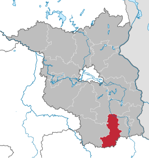
| Location of the Oberspreewald-Lausitz district in Brandenburg | |
  |
|
The district of Oberspreewald-Lausitz ( Lower Sorbian Wokrejs Górne Błota-Łužyca ) is a district in the south of Brandenburg . Neighboring districts are in the west of the Elbe-Elster district , in the north of Dahme-Spreewald , in the eastern district of Spree-Neisse and in the south the Saxon districts Bautzen and Meissen .
geography
The district of Oberspreewald-Lausitz is located in the south of the state of Brandenburg at 51 degrees north and 14 degrees east at 56 m above sea level. NHN to 201 u m. NHN . The highest mountain in the district is the Kutschenberg at 201 m above sea level. NHN , at the same time the second highest elevation in the state of Brandenburg. The district represents a very good cross-section through the Lausitz . In the south the Upper Lusatia and the beginning Lusatian Bergland , then in the middle the Lower Lusatia with the river bed of the Black Elster and the Lusatian border wall and in the north the Upper Spreewald .
Communities
After the municipal reform was completed in 2003, the district still comprised 25 municipalities, including nine cities. According to the official statement in 2016, four municipalities are officially bilingual ( German , Lower Sorbian ).
→ See also the list of places in the Oberspreewald-Lausitz district and Sorbian settlement area
(Residents on December 31, 2019)
|
Offices and associated communities 1. Altdöbern (5541)
2. Ortrand (6031)
3. Ruhland (7163)
|
  |
history
Until 1945, the Prussian districts of Hoyerswerda , Calau and Liebenwerda existed in the district of Oberspreewald-Lausitz ; from parts of this, the Senftenberg district in the Cottbus district was created in 1952 . In 1990 there was a slim majority in what was then Senftenberg district in favor of belonging to Saxony, the district council decided against affiliation to Saxony. The Oberspreewald-Lausitz district was established in 1993 as part of the Brandenburg district reform by amalgamating the Calau and Senftenberg districts and smaller parts of the Bad Liebenwerda district .
Population development
|
|
|
Territory and number of inhabitants on December 31 of the respective year, from 2011 based on the 2011 census
politics
District council
The 50 seats in the district council, which was elected on May 26, 2019, are distributed among the individual parties and groups as follows :
| Party / group | Voices 2014 | Voices 2019 | Seats 2014 | Seats 2019 | |
|---|---|---|---|---|---|
| SPD | 29.3% | 21.5% | 15th | 11 | |
| AfD | - | 19.6% | - | 10 | |
| CDU | 28.2% | 19.5% | 14th | 10 | |
| THE LEFT | 18.0% | 12.8% | 9 | 6th | |
| Free group of voters farmers - agriculture, environment, nature | 5.9% | 6.5% | 3 | 3 | |
| GREEN / B90 | 4.0% | 5.8% | 2 | 3 | |
| BVB / FREE VOTERS | 2.4% | 3.7% | 1 | 2 | |
| FDP | 2.1% | 3.6% | 1 | 2 | |
| Voice of Free Citizens (SFB) | 1.5% | 2.1% | 1 | 1 | |
| NPD | 4.3% | 1.5% | 2 | 1 | |
| Action group against social injustice Senftenberg (AGSUS) | 1.8% | 1.4% | 1 | 1 | |
| Free voter group Schwarzheide (FWS) | 1.1% | 1.1% | 1 | - |
Martina Gregor-Ness (SPD) is the chairwoman of the district assembly .
District Administrator
- 1994-2006: Holger Bartsch (SPD)
- 2006–2009: Georg Dürrschmidt (CDU), voted out of office in July
- since 2010: Siegurd Heinze (independent, for CDU)
Heinze is the first directly elected district administrator in the district. As a non-party candidate of the CDU, he received 66.4% of the valid votes in the district election on January 24, 2010.
In the district election on April 22, 2018, Heinze was confirmed in his office for another eight years with 56.3% of the valid votes.
The seat of the district administrator is in the mining house in Senftenberg.
coat of arms
The coat of arms was approved on November 25, 1994.
Blazon : "Divided by silver and blue, at the top an unarmed, striding red bull with a tail crossed over its back, at the bottom a three-pinned golden wall covered with a golden shield, inside an upright black lion."
The coats of arms of the offices, cities and municipalities of the district can be found in the list of coats of arms in the Oberspreewald-Lausitz district .
flag
The flag is striped white - red - white (1: 3: 1) and has the circular coat of arms on the median.
Economy and Infrastructure
economy
In the Future Atlas 2016 , the Oberspreewald-Lausitz district was ranked 385 out of 402 districts and independent cities in Germany, making it one of the regions with "high future risks".
The business locations Großräschen, Lauchhammer, Schwarzheide and Senftenberg are one of 15 regional growth centers in the state of Brandenburg. This promotes selected future-oriented industries.
traffic
|
Highways |
Federal highways |
Railway lines with regional and freight traffic:
- Leipzig / Halle – Calau – Cottbus line
- Berlin – Lübbenau – Cottbus – Görlitz line
- Lübbenau – Calau – Altdöbern – Senftenberg route
- Grossenhain – Ruhland – Senftenberg – Cottbus route
- Falkenberg / Elster – Lauchhammer – Ruhland – Hoyerswerda – Horka route
freight traffic only:
- Route Senftenberg - Kamenz
Furthermore, there was an extensive mine railway network that did not serve public transport, which connected the lignite opencast mines with the briquette factories and power plants.
Transportation
Local public transport is organized by the Oberspreewald-Lausitz transport company . The bus traffic is carried out by Südbrandenburger Nahverkehrs GmbH and other private bus companies. City traffic in Senftenberg and Lübbenau is organized and carried out independently by the SBN. The city traffic in Lauchhammer is organized and operated independently by the company Der Niederlausitzer .
Protected areas
There are 26 designated nature reserves in the district (as of February 2017).
License Plate
On January 1, 1994, the district was assigned the distinguishing mark OSL and has been issued ever since. Since March 15, 2013, the distinctive signs CA (Calau) and SFB (Senftenberg) have also been available.
Incorporation and amalgamation of municipalities
The table shows the incorporations and mergers of municipalities since the district was formed on December 5, 1993
| local community | date | Inclusion of | to | Merger of | to |
|---|---|---|---|---|---|
| Altdöbern | 02/01/2002 |
Ranzow Reddern |
Altdöbern | ||
| Bronkow | 10/26/2003 | Bronkow Lipten Lug |
Bronkow | ||
| Calau | December 31, 2001 |
Buckow Craupe Gollmitz Groß Jeser Zinnitz |
Calau | ||
| Calau | 10/26/2003 |
Bolschwitz Groß-Mehßow Kemmen Mlode Saßleben Werchow |
Calau | ||
| Frauendorf | December 6, 1993 | Frauendorf (outsourced from Tettau ) |
Frauendorf | ||
| Großräschen | 08/01/1997 | Free hooves | Großräschen | ||
| Großräschen | December 31, 1998 | Vozhkov | Großräschen | ||
| Großräschen | December 31, 2001 |
Allmosen Barzig Saalhausen Wormlage |
Großräschen | ||
| Hermsdorf | December 31, 2001 | Jannowitz | Hermsdorf | ||
| Lauchhammer | December 6, 1993 |
Grünewalde Kostebrau |
Lauchhammer | ||
| Luebbenau | 10/26/2003 |
Bischdorf Boblitz Groß Beuchow Groß Lübbenau Groß-Klessow Hindenberg Kittlitz Klein Radden Leipe Ragow |
Luebbenau | ||
| Luckaitztal | 03/01/2002 |
Book grove Gosda Muckwar Schöllnitz |
Luckaitztal | ||
| New Zealand | 02/01/2002 |
Railway village Lindchen Lubochow Ressen |
New Zealand | ||
| Schipkau | December 31, 2001 |
Annahütte Drochow Hörlitz Klettwitz Meuro Schipkau |
Schipkau | ||
| Senftenberg | 03/01/1997 | Sedlitz | Senftenberg | ||
| Senftenberg | December 31, 2001 |
Brieske Großkoschen Hosena Niemtsch Peickwitz |
Senftenberg | ||
| Tettau | December 6, 1993 |
Frauendorf (outsourcing) |
Frauendorf | ||
| Vetschau | December 31, 2001 |
Göritz Naundorf Repten Stradow |
Vetschau | ||
| Vetschau | December 31, 2002 |
Ogrosen Suschow |
Vetschau | ||
| Vetschau | 10/26/2003 |
Koßwig Laasow Missen Raddusch |
Vetschau |
Web links
Individual evidence
- ↑ Population in the State of Brandenburg according to municipalities, offices and municipalities not subject to official registration on December 31, 2019 (XLSX file; 223 KB) (updated official population figures) ( help on this ).
- ^ MWFK: Eight other communities belong to the Sorbs' settlement area. ( Page no longer available , search in web archives ) Retrieved on December 7, 2016.
- ↑ Population in the State of Brandenburg according to municipalities, offices and municipalities not subject to official registration on December 31, 2019 (XLSX file; 223 KB) (updated official population figures) ( help on this ).
- ^ Historical municipality register of the State of Brandenburg 1875 to 2005. District Oberspreewald-Lausitz (PDF) pp. 8–9
- ↑ Population in the state of Brandenburg from 1991 to 2015 according to independent cities, districts and municipalities , Table 7
- ^ Office for Statistics Berlin-Brandenburg (Ed.): Statistical report AI 1, A II 4. Population development and population status in the state of Brandenburg. (respective editions of the 4th quarter)
- ↑ Local elections in the state of Brandenburg on May 26, 2019, p. 20
- ↑ A woman continues to rule the district council. In: Lausitzer Rundschau , June 21, 2019.
- ↑ Final result of the district election on April 22, 2018 in the Oberspreewald-Lausitz district ( Memento from May 2, 2018 in the Internet Archive )
- ↑ Coat of arms information on the service portal of the state administration of Brandenburg
- ↑ Future Atlas 2016. Archived from the original on October 2, 2017 ; accessed on March 23, 2018 .
- ↑ Historical municipality register of the State of Brandenburg 1875 to 2005. District Oberspreewald-Lausitz , pp. 34–37.

Counties: Barnim | Dahme-Spreewald | Elbe Elster | Havelland | Märkisch-Oderland | Oberhavel | Oberspreewald-Lausitz | Oder-Spree | Ostprignitz-Ruppin | Potsdam-Mittelmark | Prignitz | Spree-Neisse | Teltow-Fläming | Uckermark
Independent cities: Brandenburg an der Havel | Cottbus | Frankfurt (Oder) | Potsdam