
Segeberg district
| coat of arms | Germany map |
|---|---|

|

Coordinates: 53 ° 55 ' N , 10 ° 8' E |
| Basic data | |
| State : | Schleswig-Holstein |
| Administrative headquarters : | Bad Segeberg |
| Area : | 1,344.39 km 2 |
| Residents: | 277,175 (Dec. 31, 2019) |
| Population density : | 206 inhabitants per km 2 |
| License plate : | SE |
| Circle key : | 01 0 60 |
| NUTS : | DEF0D |
| Circle structure: | 95 parishes |
| Address of the district administration: |
Hamburger Strasse 30 23795 Bad Segeberg |
| Website : | |
| District Administrator : | Jan-Peter Schröder (independent) |
| Location of the Segeberg district in Schleswig-Holstein | |
  |
|
The district of Segeberg ( Low German district of Sebarg ) is a district in the south of Schleswig-Holstein . It belongs to the Hamburg metropolitan region . The county seat is Bad Segeberg .
geography
The circle Segeberg is bordered to the north by the district of Rendsburg-Eckernförde , the independent city of Neumünster and the district of Plön , on the east by the district of Ostholstein , in the southeast on the circle Stormarn and the Free and Hanseatic City of Hamburg and the west by the circles Pinneberg and Steinburg .
The population and economic focus of the district is in the southwest on the settlement axis Norderstedt - Henstedt-Ulzburg - Kaltenkirchen. Around 120,000 people live here alone, almost half of the district's population, in three of the 95 communities on 120 km² of the total of 1,344 km².
history
The Segeberg district has its historical predecessor in the Segeberg Bailiwick , a military and administrative district that was formed around the Siegesburg , which was built in 1134 . After the conversion of the Vogtei into the “Amt Segeberg” in the 15th century, an administrative division of the territory into a central and western area under the authority of the bailiff and an eastern area administered by noble landlords emerged. Only after the incorporation of Schleswig-Holstein into the Prussian monarchy was the Segeberg district formed with the "Ordinance concerning the organization of the district and district authorities and the district representation in the province of Schleswig-Holstein" of September 22, 1867. The seat of the district administrator as the highest administrative officer of the district has been Segeberg since then. Baron von Willemoes-Suhm (1877-1892) is considered to be the creator of the Segeberg district administration , and he also had the district building at Hamburger Straße 30, which is still in use today, built.
With the ordinance on the reorganization of districts of August 1, 1932, the communities Boostedt , Braak , Brokenlande , Gadeland , Groß Kummerfeld , Großenaspe , Heidmühlen , Klein Kummerfeld , Latendorf , Willingrade and Wittorf of the dissolved district of Bordesholm were incorporated into the district of Segeberg. On April 1, 1938, the Segeberg district gave the municipality of Wittorf back to the independent city of Neumünster .
In addition to retaining the title of "District Administrator", the office of "District President" was created in 1950 as chairman and chairman of the district council .
In the territorial reform carried out on January 1, 1970, the district gained the newly formed town of Norderstedt , which was created from four communities in the districts of Pinneberg and Stormarn. For this he ceded the community of Gadeland to the city of Neumünster on April 26, 1970 .
On January 1, 2006 the offices of Segeberg-Land and Wensin merged to form the Office of Trave-Land . On January 1, 2008, the Boostedt municipality joined the Rickling office, which was renamed the Boostedt-Rickling office , and the Trappenkamp municipality joined the Bornhöved office .
Population development in the respective district area
The population figures refer to the respective territorial status.
| year | Residents | source |
|---|---|---|
| 1890 | 38,967 | |
| 1900 | 39,724 | |
| 1910 | 44,886 | |
| 1925 | 47,687 | |
| 1933 | 52,884 | |
| 1939 | 53,445 | |
| 1946 | 112,431 | |
| 1950 | 111.214 | |
| 1960 | 92,700 | |
| 1970 | 164,600 | |
| 1980 | 208,800 | |
| 1990 | 220,300 | |
| 2000 | 247.611 | |
| 2010 | 259,200 |
Population development today’s territory
The population figures up to 1970 refer to the area on May 27, 1970.
|
|
Denomination statistics
According to the 2011 census , 44.8% of the population were Protestant , 5.7% Roman Catholic and 49.5% were non-denominational , belonged to another religious community or did not provide any information.
politics
District council
The district council of the Segeberg district is an organ of local self-government and defines the goals and principles for the work of the district administration. The district council is elected by the citizens of the Segeberg district who are entitled to vote every five years together with the local councils at the community level. The last election took place on May 6, 2018:
| Political party | Percent 2008 | Mandates 2008 | Percent 2013 | Mandates 2013 | Percent 2018 | Mandates 2018 |
|---|---|---|---|---|---|---|
| CDU | 42.1% | 27 * | 43.7% | 25th | 37.0% | 23 |
| SPD | 26.3% | 17th | 29.0% | 16 | 21.5% | 13 |
| GREEN | 11.4% | 7th | 14.2% | 8th | 15.1% | 9 |
| FDP | 11.8% | 7th | 6.1% | 3 | 8.2% | 5 |
| AfD | - | - | - | - | 7.5% | 5 |
| Voter Initiative Segeberg (WI-SE) | - | - | - | - | 4.1% | 3 |
| THE LEFT. | 7.4% | 4th | 3.1% | 2 | 3.7% | 2 |
| FREE VOTERS | - | - | - | - | 2.9% | 2 |
| PIRATES | - | - | 3.5% | 2 | - | - |
| The Independents * | 1.0% | 2 | 0.3% | 0 | - | - |
| WE ARE THE PEOPLE (WSDV) | - | - | 0.2% | 0 | - | - |
| total | 100 | 64 | 100 | 56 | 100 | 62 |
| Turnout in percent | 47.9 | 44.9 | 43.7 | |||
All district council members are represented in the transparency portal abhabenwatch.de. There every citizen can publicly ask questions to the elected local politicians.
coat of arms
Blazon : "In silver a cross consisting of four pointed red brick towers, angled by four green water lily leaves and covered with the Holstein coat of arms in its broken-out intersection: a silver nettle leaf in red."
flag
The circular flag shows the circular coat of arms without a shield in the middle of a white cloth bordered above and below by a red stripe, slightly shifted towards the pole.
District administrators
- 1868–1870: Cay Lorenz von Brockdorff (since 1866 as bailiff)
- 1870–1877: Ernst Freiherr von Gayl
- 1877–1891: Peter Friedrich von Willemoes-Suhm
- 1892–1901: Karl Graf von Platen-Hallermund
- 1901–1928: Gustav Ludwig L. Otto Ilsemann
- 1928–1932: Otto zu Rantzau
- 1932–1945: Waldemar von Mohl
- 1945–1946: Christian Laurup Jensen
- 1946–1950: Paul Pagel
- 1950–1959: Walter Alnor
- 1959–1966: Joachim Dorenburg
- 1966–1990: Count Anton Schwerin von Krosigk
- August 1, 1990 - July 31, 2008: Georg Gorrissen
- August 1, 2008 - August 31, 2008: Claus-Peter Dieck (acting)
- September 1, 2008 - August 31, 2014: Jutta Hartwieg
- since September 1, 2014: Jan-Peter Schröder
economy
In the Future Atlas 2016 , the Segeberg district was ranked 138th out of 402 districts, municipal associations and independent cities in Germany, making it one of the regions with “future opportunities”. The district ranks second within Schleswig-Holstein.
The economic focus of the district is on the A 7 on the Norderstedt - Henstedt-Ulzburg - Kaltenkirchen axis. In the more rural north-east of the district with the district town of Bad Segeberg as the center, the economic strengths are in the health industry (including Segeberger clinics), local recreation and tourism (including Karl May Games Bad Segeberg and the Holstein Switzerland Nature Park ).
traffic
The A 7 runs through the district in the western part with the junctions Henstedt-Ulzburg, Kaltenkirchen, Bad Bramstedt and Großenaspe. The A 21 crosses the district to the east . The extension of the A 20 from Lübeck across the Segeberg district to a junction with the A 7 near Bad Bramstedt and on through the Steinburg district to a new Elbe crossing is planned as a new east-west connection .
The rail opens up the district with several railway lines:
- the Neumünster - Bad Segeberg - Bad Oldesloe railway runs in the northeastern part of the district
- the Neumünster - Hamburg (AKN) line opens up the western part and runs roughly parallel to the A7 motorway
The " Alsternordbahn " Ulzburg Süd - Norderstedt Mitte and the Henstedt-Ulzburg - Elmshorn railway branch off from the AKN line . You have further stops in the Segeberg district.
The Hamburg underground line U1 has three stops in the district between Norderstedt Mitte and Garstedt .
The entire public transport system was incorporated into the HVV in 2003 . Previously, only the southern part of the Segeberg district (including Norderstedt and Henstedt-Ulzburg) belonged to the transport association.
The Hamburg-Kiel railway line has two stations, Wrist and Brokstedt, at a distance of a few 100 meters from the western border of the Segeberg district. The HVV tariff does not apply here.
science
The largest scientific institution in the Segeberg district is the internationally recognized Borstel Research Center .
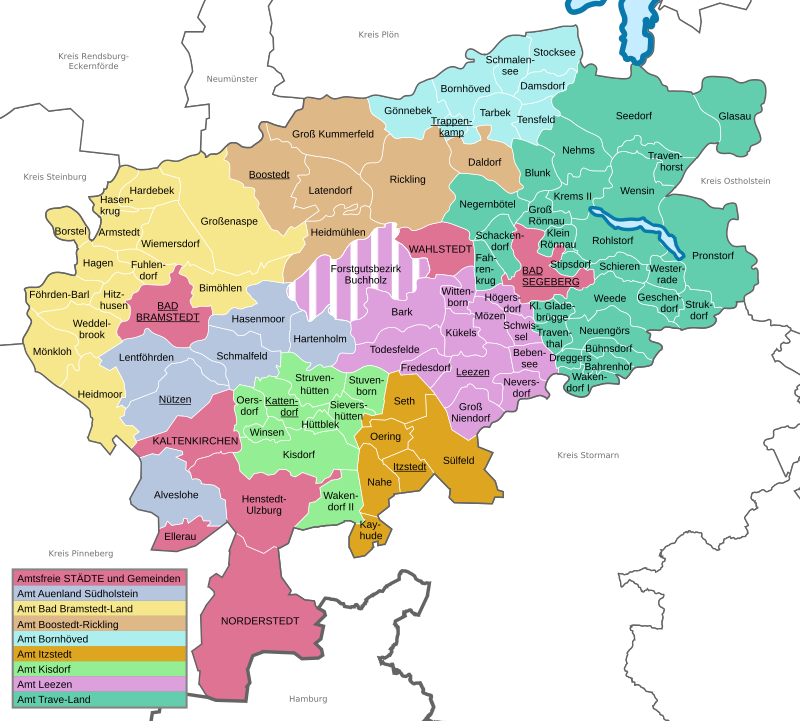
Communities
(Residents on December 31, 2019)
| Municipalities not in office | |
|---|---|
|
|
Offices with official municipalities (* = seat of the official administration)
Municipality and office map

Former parishes
The following communities in the Segeberg district were incorporated into other communities during its existence:
The two present-day communities of Klein Gladebrügge and Traventhal were merged from January 1, 1974 to January 1, 1998 to form a community of Groß Gladebrügge . Until its dissolution in the 1920s, there were also a large number of manor districts in the Segeberg district . The Buchholz forest estate continues to this day.
Protected areas
There are 15 designated nature reserves in the district (as of February 2017).
License Plate
On July 1, 1956, the district was assigned the SE distinctive sign when the vehicle registration number that is still valid today was introduced . It is still issued today.
literature
- Gerhard Hoch: The term of office of the Segeberg District Administrator Waldemar von Mohl 1932–1945 . Hamburg 2001, ISBN 3-933374-92-8
- Hans-Peter Sparr: 1867–1992. 125 years of the Segeberg district. A photo journey ... through the ages. Kalkberg-Verlag, Bad Segeberg 1993, ISBN 3-928928-02-3 .
Web links
- Official website of the Segeberg district
- Official website of the Segeberg District Economic Development Corporation
- Website KUNST @ SH: Works of art in public space in the Segeberg district
Individual evidence
- ↑ North Statistics Office - Population of the municipalities in Schleswig-Holstein 4th quarter 2019 (XLSX file) (update based on the 2011 census) ( help on this ).
- ↑ PrGS 1867, 1587
- ^ Territorial changes in Germany: Segeberg district
- ↑ a b c d e f g h i Michael Rademacher: German administrative history from the unification of the empire in 1871 to the reunification in 1990. segeberg.html. (Online material for the dissertation, Osnabrück 2006).
- ↑ 1946 census
- ↑ Statistical Yearbook for the Federal Republic of Germany 1972
- ↑ Statistical Yearbook for the Federal Republic of Germany 1981
- ↑ a b North Statistics Office
- ↑ State Statistical Office Schleswig-Holstein (Ed.): The population of the communities in Schleswig-Holstein 1867-1970 . State Statistical Office Schleswig-Holstein, Kiel 1972, p. 21 .
- ↑ Segeberg Religion District , 2011 census
- ↑ https://www.segeberg.de/media/custom/2211_1655_1.PDF?1526466556
- ↑ http://www.segeberg.de/media/custom/1822_378_1.PDF
- ^ Segeberg district: the district council
- ↑ Wolfgang Glombik: Alliance of "CDU injured". In: Hamburger Abendblatt . October 23, 2008, accessed July 16, 2014 .
- ↑ [1]
- ^ Result of district election 2013 follow-up ( Memento from August 12, 2014 in the Internet Archive )
- ↑ [2]
- ↑ [3]
- ↑ parliament watch.de: Segeberg district council ( Memento from July 10, 2011 in the Internet Archive )
- ↑ a b Schleswig-Holstein's municipal coat of arms
- ↑ Future Atlas 2016. (No longer available online.) Archived from the original on October 2, 2017 ; accessed on March 23, 2018 .
- ↑ North Statistics Office - Population of the municipalities in Schleswig-Holstein 4th quarter 2019 (XLSX file) (update based on the 2011 census) ( help on this ).
- ↑ State Statistical Office Schleswig-Holstein (Ed.): The population of the communities in Schleswig-Holstein . Historical municipality directory: Segeberg district. Kiel 1972 ( digitized from genealogy.net [accessed on April 21, 2015]).
- ^ StBA: Changes in the municipalities in Germany, see 1998
- ^ Municipalities and manor districts in the Segeberg district, as of 1910
Independent cities: Flensburg | Kiel | Lübeck | Neumunster
Districts: Dithmarschen | Duchy of Lauenburg | North Friesland | Ostholstein | Pinneberg | Plön | Rendsburg-Eckernförde | Schleswig-Flensburg | Segeberg | Stone castle | Stormarn