
Moselle
| Moselle | ||
 Course map of the Moselle ( interactive map ) |
||
| Data | ||
| Water code | FR : A --- 0060 , DE : 26 | |
| location | France | |
| River system | Rhine | |
| Drain over | Rhine → North Sea | |
| source | at Col de Bussang , Vosges 47 ° 53 ′ 22 ″ N , 6 ° 53 ′ 34 ″ E |
|
| Source height | approx. 696.5 m | |
| muzzle | in Koblenz in the Rhine Coordinates: 50 ° 21 '56 " N , 7 ° 36' 23" E 50 ° 21 '56 " N , 7 ° 36' 23" E |
|
| Mouth height | approx. 59.7 m above sea level NHN | |
| Height difference | approx. 636.8 m | |
| Bottom slope | approx. 1.2 ‰ | |
| length | 544 km (of which 231.5 km in Germany) |
|
| Catchment area | 28,153.275 km² | |
| Discharge at the gauge Cochem A Eo : 27,088 km² Location: 51.6 km above the mouth |
NNQ (June 28, 1976) MNQ 1900–2015 MQ 1900–2015 Mq 1900–2015 MHQ 1900–2015 HHQ (December 22, 1993) |
10 m³ / s 60.1 m³ / s 313 m³ / s 11.6 l / (s km²) 2010 m³ / s 4020 m³ / s |
| Discharge at the mouth of the A Eo : 28,153 km² |
MQ Mq |
320 m³ / s 11.4 l / (s km²) |
| Left tributaries | Madon , Esch , Rupt de Mad , Orne , Sauer , Kyll , Salm , Lieser , Alf , Elz | |
| Right tributaries | Moselotte , Vologne , Meurthe , Seille , Saar , Ruwer , Dhron | |
| Big cities | Metz , Trier , Koblenz | |
| Residents in the catchment area | 4.3 million | |
| Ports | Trier , Mertert , Thionville , Metz , Frouard | |
| Navigable | 394 km from Koblenz to Neuves-Maisons | |
The Moselle ( French Moselle , Luxembourgish Musel ) is 544 km long and is the second longest tributary of the Rhine after the Maas . The river has its source in France , in the Vosges at Col de Bussang . In Lorraine it flows through Remiremont and Épinal , in a wide arc around Nancy to Metz and further north. Then it forms the border between Luxembourg and Germany . Soon afterwards it reaches Trier . The German Moselle valley is characterized by the strongly meandering course with many vineyards on partly very steep slopes. The Moselle flows into the Middle Rhine in Koblenz .
From 1958 to Neuves-Maisons, the river was canalised by its neighboring states as part of the Moselle canalisation and thus developed into a major shipping route. From the German-French border to the mouth, the Moselle belongs to waterway class Vb. The inhabitants of the Moselle call themselves Moselaner .
Surname
The name Mosel is derived from the Celtic form of the name Mosea via the Latin Mosella , a diminutive of Mosa , the Latin name of the Meuse, which initially ran parallel to the river.
The Moselle was first mentioned by Tacitus in Book 13 of the Annals and in Book 4 of the Histories.
The Roman poet Decimius Magnus Ausonius set her a literary monument in the 4th century. In his 371 poem Mosella , written in 483 hexameters , the late antique poet and teacher at the Trier imperial court describes a journey from Bingen via the Hunsrück to the Moselle and its course, to Trier ( Ausoniusstraße ). Ausonius depicts blooming and rich landscapes on the river and in the valley of the Moselle, which they owe not least to the politics of the late antique rulers.
geography
overview

The Moselle rises in the southern Vosges near the Col de Bussang at an altitude of about 700 m and flows into Koblenz at the Deutsches Eck , whose north-northeast end at 64.7 m above sea level. NHN lies at 59.7 m from the west in the Rhine .
The mean discharge at the mouth is 320 m³ / s, making the Moselle the third largest tributary of the Rhine after Aare (560 m³ / s) and Maas (357 m³ / s) as well as before Main and Neckar .
River sections
The section of the Moselle from the German - French - Luxembourg border triangle to the confluence of the Saar near Konz just before Trier is called the Upper Moselle in Germany (geographically incorrect) . The area from Trier to Pünderich is called the Middle Mosel , the section between Pünderich and the confluence in Koblenz is called the Untermosel or terrace Moselle. The valley meanders cut deep into the plateaus of the Rhenish Slate Mountains , the most striking of which is the Cochemer Krampen between Bremm and Cochem , as well as the vineyard terraces are characteristic of the Central and Lower Moselle .
From the border triangle, the Moselle marks the entire Saarland-Luxembourg border.

Moselle in Pont-à-Mousson (FR)

Moselle in Metz (FR)

Moselle in Schengen (L)
Moselle in Remich (L)

Moselle valley: Trier valley width from the Löschemer chapel , Wasserliesch (DE)

Moselle in Trier (DE)

Coupling association between Reil and Burg (DE)

Moselle loop near Bremm (DE)
Cochem on the Lower Mosel (DE)
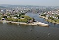
Koblenz: Rhine (front) and Moselle (back) at the Deutsches Eck (DE)


.jpg)


Catchment area
.png)
The catchment area of the Moselle is 28,153.275 km². With 15,360 km², the French part makes up about 54.5 percent of the total area and today belongs to the Grand Est region , historically almost entirely part of Lorraine . Rhineland-Palatinate has 6,980 km², Saarland 2,569 km², Luxembourg 2,521 km², Belgian Wallonia 767 km² and North Rhine-Westphalia 88 km².
Tributaries


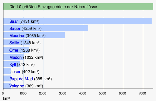
- See also: List of tributaries of the Moselle
Selected locations
| Surname | Residents: F: Municipality D: Ortsgem. |
Residents: F: Aire urbaine D: VerbandsG. |
Elevation [m] |
annotation |
|---|---|---|---|---|
| France | ||||
| Rupt-sur-Moselle | 3,454 | 399-898 | ||
| Remiremont | 7,768 | 22,936 | 400-766 | |
| Epinal | 32.006 | 116,000 | 315-492 | |
| Charms | 4,683 | 258-385 | ||
| Nancy | 104,321 | 434.479 | 188-353 | on the Meurthe, but the center upstream and downstream only 9 km from the Moselle |
| Toul | 15,966 | 23,180 | 200-400 | |
| Pont-à-Mousson | 14,904 | 26,948 | 172-382 | |
| Metz | 117,619 | 389.851 | 162-256 | |
| Hagondange | 9,343 | 154-209 | ||
| Thionville | 41,083 | 157.493 | 147-423 | |
| Cattenom | 2,775 | 148-237 | Cattenom nuclear power plant | |
| Sierck-les-Bains | 1,690 | 145-337 | only in the 19th century for a short time spa operation (thermal bath) | |
| Luxembourg | ||||
| Schengen | 4,615 | 141-302 | ||
| Remich | 3,482 | 142-253 | ||
| Grevenmacher | 4,794 | 133-315 | ||
| Water cheap | 3,029 | Mertert municipality | ||
| Germany | ||||
| Pearl | 2,253 | 8,351 | ||
| Conc | 17,966 | 31,553 | 155 | |
| trier | 114.914 | 137 | ||
| Keep quiet | 7,627 | 27,764 | 133 | |
| Neumagen-Dhron | 2,300 | 130 | Verbandsgemeinde Bernkastel-Kues | |
| Piesport | 2.007 | 119 | Verbandsgemeinde Bernkastel-Kues | |
| Bernkastel-Kues | 6,987 | 27,830 | 110 | |
| Zeltingen-Rachtig | 2.211 | 106 | Verbandsgemeinde Bernkastel-Kues | |
| Traben-Trarbach | 5,768 | 17,624 | 110 | |
| Cell | 4,085 | 15,767 | 100 | |
| Cochem | 5,332 | 20.008 | 85 | |
| Treis cards | 2,221 | 87 | Verbandsgemeinde Cochem | |
| Kobern-Gondorf | 3,150 | 26,738 | ||
| Koblenz | 112,586 | 73 | ||
geology
The Vosges , today's headwaters of the Moselle , emerged about 50 million years ago . In the Miocene and Pliocene , the ancient Moselle was already a tributary of the ancient Rhine . When the Rhenish Slate Mountains slowly rose in the Quaternary , the meander of the Moselle formed between the Trier Valley and the Neuwied Basin .

Water levels

Highest shipping water level (HSW) at 695 cm and normal water level (NSt) at 200 cm at the Trier gauge.
Flood :
- 11.28 m, Trier gauge on December 21, 1993
- 10.56 m, Trier gauge on May 28, 1983
- 10.33 m, Trier gauge on January 23, 1995
- 10.26 m, Trier gauge on April 12, 1983
- 9.92 m, Trier gauge on February 27, 1997
- 0.47 m in Bernkastel on July 28, 1921
economy
shipping
After the Second World War, France pushed for larger ships to be able to sail the Moselle in order to be able to connect the Lorraine industrial areas. When the people of the Saar decided in favor of the Federal Republic of Germany in 1955, France demanded the expansion of the Moselle as compensation . In the Moselle Treaty of October 27, 1956, it agreed the Moselle canalization with the Federal Republic of Germany and Luxembourg and in return granted Germany the so-called loop solution on the Upper Rhine (instead of expanding the Rhine canal beyond Breisach). Construction work began in 1958, and on May 26, 1964, the Moselle from Metz to Koblenz was officially opened as a congestion-regulated large shipping route with 14 barrages . France extended the expansion to Neuves-Maisons by 1979 .
This means that 394 km of the Moselle have been expanded with a total of 28 barrages. In the years 1992 to 1999, the fairway was deepened from 2.70 m to 3.00 m, which gives a 1500-ton freighter an approximately 20% increase in cargo. The fairway is 40 m wide, widened in curves. The International Moselle Commission (IMK) founded in 1962 and based in Trier is responsible for shipping . The Moselle Shipping Police Ordinance drawn up by it applies in all three neighboring states, i.e. from Metz to Koblenz.
As early as 1970, more than ten million tonnes of goods were being transported on the Moselle, a large part of them with push convoys; to the mountain mainly fuels and ores, to the valley steel products, gravel and stones.
administration
The Moselle was since 1921 Reich waterway, today it is a federal waterway from Apach ( barrage Apach up to its confluence with the Rhine at Rhine-km) on the border triangle in Koblenz to 242 kilometers in length from 592.29 waterways and shipping offices Trier and Koblenz managed . It is classified as a European waterway Vb. Your kilometer reading begins at the mouth with km 0 and runs against the direction of flow upwards.
From Apach, the Moselle has formed a condominium over a length of 36 km since 1816, a joint German-Luxembourg territory for which the distribution of tasks has been regulated in an agreement since 1976. The Internationale Mosellegesellschaft, founded in 1957 initially to finance the expansion, administers the shipping taxes and the operating and maintenance costs to be covered.
Infrastructure
There is a port in Trier and a transshipment point in Zell (Mosel) ; other ports are in Mertert , Thionville , Metz and Frouard . In addition to freight shipping, excursion boats operate between the wine villages, some of which are very intensively developed for tourism, and small towns in the Central and Lower Moselle.
There are yacht or sports harbors in the following places: Koblenz , Winningen , Brodenbach , Burgen , Löf , Hatzenport , Senheim , Treis , Traben-Trarbach , Kues , Neumagen , Pölich , Schweich , Trier, Konz and Schwebsingen . At Toul , the Moselle is connected to the Maas , Saône and Rhone , among others, via the Canal de la Marne au Rhin . The North Sea and the Mediterranean can be reached via other channels .
Barrages

A total of 28 barrages are located along the Moselle.
- 16 in France near Neuves-Maisons , Villey-le-Sec , Toul , Fontenoy-sur-Moselle , Aingeray , Frouard - Pompey , Custines , Blénod-lès-Pont-à-Mousson , Pagny-sur-Moselle , Ars-sur- Moselle , Metz , Talange , Richemont , Thionville , Kœnigsmacker and Apach
- 2 between Luxembourg and Germany at Stadtbredimus - Palzem and Grevenmacher - Wellen
- 10 in Germany near Trier, Detzem , Wintrich , Zeltingen , Enkirch , St. Aldegund , Fankel , Müden , Lehmen and Koblenz . The barrage at Detzem has the greatest drop height of nine meters and the longest retention at 29 kilometers ; it is the only barrage with a lock canal.
Except in Detzem, all structures of a barrage are arranged side by side, with the lock on one bank, the weir in the middle of the river and the hydroelectric power station on the other bank. Between the lock and the weir are the boat tow / boat lane and the boat lock, and the fish ladder is between the weir and the power station .
Every year in summer the locks are closed to shipping for eight to ten days so that maintenance and repair work can be carried out. So that shipping can plan for this closure, the dates are decided and announced by the Moselle Commission for ten years in advance.
All buildings are fitted into the landscape with low structures; this was achieved through the choice of sector weir locks as well as lifting gates in the heads and miter gates in the lower heads of the locks. The dam targets and hydropower plants are controlled by the central control room of RWE Power AG at Fankel .
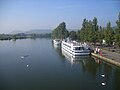
tourism

The Moselle Wine Route and the Moselle Cycle Route run in the Moselle Valley, which is 311 kilometers from Metz in France via Trier to Koblenz am Rhein . Between Koblenz and Trier, large parts of the route of the former Moselle Valley Railway run away from car noise and exhaust fumes . This was last possible on June 11, 2017, on the Sunday after Whitsun on the 140 kilometers between Schweich and Cochem, also car-free as part of the Happy Mosel Day.


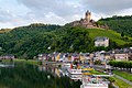
A number of remarkable castles and ruins adorn the heights above the Moselle valley, and a sightseeing tour by ship is also worthwhile.
The Moselhöhenweg has been running along the Moselle since 1910 , a hiking trail that is 185 km long on the Eifel side and 262 km on the back of the Huns. A special hike leads from Ediger-Eller over the Calmont via ferrata to Bremm through the steepest vineyard in Europe.
Before the barrages were built, the Moselle was a popular migratory river for folding boaters, which is why many barrages have boat lanes . The river is still used by many canoeists today, especially during the weekly lock closures that take place in early summer - then without commercial shipping.
The Moselsteig Trail was opened in April 2014 and runs for a total of 365 kilometers from Perl on the Upper Moselle to Koblenz . Numerous Moselsteig partner trails, the so-called side jumps and dream trails , complement the hiking options in the Moselle valley.
The ADAC Rallye Deutschland has also been taking place in the vineyards on the Moselle since 2000 ( Veldenz , Dhron , Piesport , Minheim , Kesten , Trittenheim , Fell , Ruwertal , Trier).
At the Koblenz barrage , the Mosellum offers exhibitions on fish migrations in the Moselle as well as on aquatic ecology, shipping and power generation. With the construction of the visitor and information center, the most modern fish ladder along the Moselle was put into operation.
The Moselle region was recommended as a travel destination in early 2016 in the New York Times' Special 52 Places to Go in 2016 .
16 sculptures from the sculpture symposium Stones on the River have been decorating the section between Palzem and Konz since 1999 and 2001 respectively .
Viticulture

There is a wine-growing area on the Moselle with an area of around 10,540 hectares. The federal states of Rhineland-Palatinate and Saarland have the largest share in Germany, currently almost 9,000 hectares, while the Luxembourg part has an area of around 1,300 hectares (see viticulture in Luxembourg ). Up the Moselle, cultivation in France extends to the Seille in the Côtes de Moselle area with an area of 130 ha and to the area around Toul ( Côtes de Toul ) with an area of 110 ha.
The German Moselle wine region, with all its tributaries, has had the cultivation or designation of origin "Mosel" since 2007 (until 2006 Mosel-Saar-Ruwer ). For marketing reasons, the chambers of agriculture divide the region into six wine-growing areas . The wine literature and specialist press, on the other hand, use a four-way division, for which geomorphological, small-climatic and historical reasons speak:
- The river landscape of the Upper Moselle , with its predominantly shell limestone soils, belongs geologically to the so-called Paris Basin , which explains the only 10% share of Riesling (2010) and the increasing cultivation of white and red Burgundy vines. The main grape variety on the German side of the Moselle is the autochthonous grape variety Elbling with around 65% .
- Around the city of Trier and in the valleys of the Saar and Ruwer with their side valleys, Riesling is the predominant grape with over 80% on slate rock soils. A climatic peculiarity of this area is the frequent alignment of the often small-scale parceled locations in southwest-southeast orientation, in which the plants are exposed to stronger cooler winds and, especially before the recent global warming, often reach lower degrees of ripeness than in the narrow, often deeply incised Valley of the Central and Terrassenmosel .
- With around 6,000 hectares of vineyards, the Middle Moselle is the largest growing area in the Moselle. According to the judgments of the professional world and the trade, the "great" wines of the Moselle grow here, in large land-level locations and in famous steep slopes, both in quantity and quality.
- In the Lower Moselle valley, viticulture shows its most picturesque side: Medieval castles in large numbers over half-timbered, small villages, surrounded by small terraced steep slopes in the narrow, winding valley. Here the workload is particularly high and the income difficult to generate. Therefore, the sight of dilapidated vineyards is common here.
Wine growing on the German Moselle has been declining for decades. In 2005 statistics recorded 10,375 hectares, compared to 8,491 in 2012. Mostly, areas on extremely steep slopes have fallen fallow. The number of so-called part-time winemakers, or small and family farms, is particularly declining, which until the end of the 1960s provided the majority of wine-growing businesses. Comparative figures from the Rhineland-Palatinate Chamber of Agriculture for some wine locations on the Terrassenmosel z. For example, at the beginning of the 1960s there were 797 companies, and at the beginning of the 2000s there were just under 100 companies.
A contrary tendency can be seen in the group of established traditional wineries and younger winemakers with a sound training in oenology and business administration, who are expanding their businesses with the recultivation of renowned, long-forgotten locations. The use of the special terroir for increasing quality and value, which was "rediscovered" at the end of the 20th century , has led to a more differentiated judgment about "the" Moselle wine, which until a few years ago was still in the public eye for overproduction, fraudulent labeling and cheap offers.
Umbrella brand Mosel
On 10 November 2006, in Burg (Mosel) , the Regional Initiative Mosel founded. The introduction of the Mosel umbrella brand is planned based on the Eifel umbrella brand , which includes goods and services from the fields of agriculture and forestry, tourism, handicrafts and nature.
Moselle slate
Moselle slate is a name of origin and trade name for slate from the districts of Mayen, Polch, Müllenbach, Trier and the surrounding area. Today only the products from the roof slate mines Grube Katzenberg and Margareta in Mayen carry the name Moselle slate . The name comes from the historical transport route of this slate across the Moselle to the Lower Rhine.
Bridges over the Moselle


An (incomplete) list can be found under List of Moselle Bridges . Separate articles exist for the following bridges:
- Moselle viaduct
- Schengen Viaduct
- Hindenburg Bridge near Igel / Mosel (destroyed 1945)
- Konzer Moselle Bridge
- Konrad-Adenauer-Bridge in Trier
- Roman bridge in Trier
- Kaiser Wilhelm Bridge in Trier
- Trier-Pfalzel railway bridge
- Moselle bridge Trier-Ehrang
- Moselle Bridge Schweich (L141)
- Moselle valley bridge near Schweich
- Hochmosel Bridge
- Alf-Bullay double-decker bridge
- Skagerrak Bridge in Cochem
- Treiser Moselle Bridge
- Moselle bridge Löf-Alken
- Moselle valley bridge between Winningen and Dieblich
- Güls railway bridge in Koblenz
- Kurt Schumacher Bridge in Koblenz
- Europabrücke in Koblenz
- Moselle railway bridge
- Balduin Bridge in Koblenz
Replacement transfer points
Replacement crossing points (NATO ramps) are at Löwener Mühle , Schweich , Longuich and Müden .
See also
- Moselbahn and Mosel route , the railway lines on the Moselle
- List of rivers in Germany
- Wine festival of the Middle Moselle
- Schunkellied O Mosella by Karl Berbuer
- Moselle song In the wide German land by Georg Schmitt
- Zeltinger Himmelreich (Operetta)
literature
- Decimius Magnus Ausonius: Mosella [description of a boat trip on the Moselle around 371 AD]
- Jakob Hölscher (Ed.): The Moselle valley from Trier to Coblenz. In picturesque views, drawn from nature by C. Bodmer , etched in acqua tinta by R. Bodmer . 30 sheets. Koblenz 1831-1833.
- Johann August Klein: Moselthal between Koblenz and Konz, printed by Heriot, Coblenz 1831.
- Johann August Klein: The Moselle valley between Koblenz and Zell with cities, towns, knight castles, historical, topographical, picturesque . Heriot, Koblenz 1831.
- Wilhelm Haag: Ausonius and his Mosella . Gaertner, Berlin 1900.
- Michael Gerhard: The Moselle, represented in its course, its formation and its importance for people. Prüm 1910. Online edition dilibri Rhineland-Palatinate .
- Carl Hauptmann: The Moselle from Cochem to Bernkastel. Bonn 1910. Online edition dilibri Rhineland-Palatinate .
- Carl Hauptmann: The Moselle from Coblenz to Cochem in moving pictures. Bonn 1911. Online edition dilibri Rhineland-Palatinate .
- Ludwig Mathar: Die Mosel (The Rhineland, Pictures of Land, People and Art, second volume: Die Mosel) Cologne undated (around 1925), 607 p. (With 117 illustrations and a map of the Moselle valley from Trier to Coblenz) .
- Rudolf G. Binding: Moselle trip out of lovesickness - Novella of a landscape , Frankfurt am Main 1933 (51st – 75th thousand).
- Josef Adolf Schmoll called Eisenwerth : The Moselle from the source to the Rhine ( Deutsche Lande - Deutsche Kunst ). 2nd edition, Munich / Berlin 1972.
- Willy Leson (Hrsg.): Romantic journey through the Moselle valley from Koblenz to Trier (with graphics by Carl Bodmer and texts by Johann August Klein and Christian von Stramberg ) , Cologne 1978.
- Heinz Cüppers, Gérard Collot, Alfons Kolling, Gérard Thill (ed.): The Romans on the Moselle and Saar (evidence of Roman times in Lorraine, Luxembourg, in the Trier area and Saarland) , Mainz 1983, Zabern: 2nd corrected. Edition (with 46 color and 346 black and white illustrations).
- Heinz Held: The Moselle from the mouth near Koblenz to the source in the Vosges: landscape, culture, history (DuMont art travel guide). 3rd edition, Cologne 1989.
- Renate Kissel: A guest on the Moselle - specialties from the source to the mouth , (with pictures by Dieter Portugall), Weingarten art publisher, 1998, ISBN 3-8170-0035-9 .
- M. Eckoldt (Ed.), Rivers and Canals, The History of German Waterways, DSV-Verlag, 1998.
- Ulrich Nonn: A journey through the Moselle in the 4th century Decimus Magnus Ausonius and his "Mosella" . In: Koblenz Contributions to History and Culture, Vol. 8, Koblenz: Görres-Verlag 2000, pp. 8–24 (with map and illustrations).
- Reinhold Schommers : The Mosel (DuMont travel paperbacks). DuMont, Ostfildern 2001, ISBN 3-7701-3741-8 .
- Ludwin Vogel: Germany, France and the Moselle. European integration policy in the mining regions of the Ruhr, Lorraine, Luxembourg and the Saar. Klartext, Essen 2001, ISBN 3-89861-003-9 .
- Decimius Magnus Ausonius : Mosella. Latin-German. Edited, translated and commented by Paul Dräger . Tusculum study expenses. Artemis and Winkler, Düsseldorf 2004, ISBN 3-7608-1380-1 .
- Uwe Anhäuser: The Ausoniusstrasse. An archaeological travel and hiking guide. Rhein-Mosel, Alf / Mosel 2006, ISBN 3-89801-032-5 .
- Karl-Josef Gilles : The Moselle valley between Koblenz and Trier 1920 to 1950 (series archive images), Sutton, Erfurt 2006, ISBN 978-3-89702-943-9 .
- Wasser- und Schifffahrtsdirektion Südwest: Compendium of the Wasser- und Schifffahrtsdirektion Südwest. Organizational and technical data, inland navigation, tasks, waterways. Self-published, Mainz June 2007.
- Alexander Thon / Stefan Ulrich: Blown by the showers of the past ... castles and palaces on the Moselle . Schnell + Steiner, Regensburg 2007, 1st edition, 180 p. Numerous. Fig., 2 Moselle overview maps
- Wolfgang Lambrecht: Picturesque Moselle - paintings and prints from 100 years , [color brochure with works a. a. by Carl Bodmer, Clarkson Stanfield, Rowbotham, Compton, Wolfsberger, Benekkenstein, Burger, Thoma, Nonn, Möhren, Zysing and Bayer, published by Sparkasse Mittelmosel and Lions-Förderverein Cochem], Cochem 2007.
- Karl-Josef Schäfer and Wolfgang Welter: A Way of St. James from Koblenz-Stolzenfels to Trier. The pilgrim guide for the Moselle Camino. Books on Demand, Norderstedt 2009 (2nd updated edition) ISBN 978-3-8334-9888-6 .
- Xavier Deru: The Romans on the Meuse and Moselle , Zabern-Verlag, Mainz 2010.
- Groben, Josef: Mosella. Historical-cultural monograph , Trier 2011, 311 pp., 237 ills.
- Klaus Freckmann: The Moselle - Art and Culture. Petersberg 2011, 160 p., 190 color illustrations, hardback.
- Stefan Barme: Naked ass, Viez and leather thong - excursions into the cultural history of the Moselle region . Stephan Moll Verlag, 2012 (1st edition) ISBN 978-3-940760-37-1 .
- Joachim Gruber: Decimus Magnus Ausonius: "Mosella" . Critical edition, translation, commentary (= texts and comments . Volume 42 ). Walter de Gruyter, Berlin November 2013 (370 pages).
- Ludwig Zöller (Hrsg.): The physical geography of Germany . Scientific Book Society, Darmstadt 2017, ISBN 978-3-534-26868-9 , 6 River History of Central Europe - Change, Surprise, Crime. 6.4 The daughter older than the father - the Moselle and Maas system, pp. 124–134.
- Nicole Sperk: Moselle. 5th updated edition. DuMont Reiseverlag, Ostfildern 2019, ISBN 978-3-7701-7571-0 . (With separate map 1: 260,000)
Web links
- Moselkommission , on moselkommission.org
- Moselhöhenweg , on outdoorseiten.net
- Water quality of the Moselle in Rhineland-Palatinate 1964 to 2000 , at the State Office for the Environment Rhineland-Palatinate (LfU), Mainz, February 2002, on luwg.rlp.de (PDF; 7.97 MB)
- International area "Mosel-Saar" - inventory , published by International Commissions for the Protection of the Moselle and Saar, June 2005, on eau.public.lu (PDF; 29.7 MB)
- Interactive map of the Luxembourg waterways network, "Cours d'eau du Grand-Duché de Luxembourg"
References and comments
- ↑ a b RWE Innogy:Our hydropower plants on the Moselle; Data and facts , accessed on February 15, 2016. For the Koblenz barrage , an upper water storage target of 65.0 m is specified and an average head of 5.3 m, which results in an average underwater height of 59.7 m. This corresponds to the fact that on topographic maps with M = 1: 5000 [as in the map service of the landscape information system of the Rhineland-Palatinate nature conservation administration (LANIS map) ( notes )] the 60 m contour line at the Koblenz water and shipping office on the north bank of the Moselle still appears.
- ↑ a b c GeoExplorer of the Rhineland-Palatinate Water Management Authority ( memento of the original from October 24, 2014 in the Internet Archive ) Info: The archive link was inserted automatically and has not yet been checked. Please check the original and archive link according to the instructions and then remove this notice. , on geoexplorer-wasser.rlp.de
- ↑ Federal Institute for Hydrology: Undine data service ( Memento from August 14, 2016 in the Internet Archive ) , accessed on August 14, 2016
- ↑ a b level value Cochem increased by the area of effluent (6 l / s.km²) of the rest of basin (1065 square kilometers) to the mouth. Note: The comparable neighboring catchment area of the Nette water level Nettegut has an area discharge of 6.3 l / s.km².
- ↑ The Moselle and the Saar (river basin community Rhine), accessed on May 23, 2016, at fgg-rhein.de
- ^ Musel : Moselle Franconian word for Moselle; is also along the German Mosel in dialect until after Koblenz expressed as
- ↑ Alfons Krisam: Germany and the Moselaner: cheerful view with profound seriousness , ISBN 978-3-922812-00-5 , German National Library, on portal.dnb.de
- ↑ Publius Cornelius Tacitus: The text is available in the Latin Wikisource: Chapter LIII , on la.wikisource.org
- ^ Publius Cornelius Tacitus: The text is available in the Latin Wikisource; the Moselle is mentioned in Chapter 71 and Chapter 77 , on la.wikisource.org
- ↑ The Meuse with 357 m³ / s is, with an interruption from 1904 to 1970, hydrologically a tributary of the Rhine (expressed in the official water code number 28 for the Meuse and 2 for the Rhine), but is administratively managed in a separate river basin district, so that it is often disregarded.
- ↑ core town Konz 12,315 inhabitants, local community 17,966
- ↑ Directory A, Ser. No. 39 of the Chronicle. Retrieved November 21, 2019 . , Federal Waterways and Shipping Administration, at www.gdws.wsv.bund.de
- ↑ Directory E, Ser. Chronicle No. 34. Retrieved November 21, 2019 . , Federal Waterways and Shipping Administration, at www.gdws.wsv.bund.de
- ↑ a b c Outline of federal waterways . Retrieved November 21, 2019 . , with information and a. For lengths (in km) of the main shipping routes (main routes and certain secondary routes) of the federal inland waterways, at the Federal Waterways and Shipping Administration, at www.gdws.wsv.bund.de
- ^ Moselkommission.org: Lock closure times on the Moselle
- ↑ Lock closure times on the Moselle 2017 to 2025 ( page no longer available , search in web archives ) (pdf, 387 MB) at moselkommission.org, accessed on May 21, 2017
- ↑ Moselsteig ignites wandering fever . In: Trierischer Volksfreund , from September 26, 2014. Retrieved on September 26, 2014, from volksfreund.de
- ↑ "New York Times" recommends Reise an die Mosel , Rhein-Zeitung , Koblenz, January 8, 2016, on rhein-zeitung.de
- ↑ Denomination of origin not used by the majority of winemakers
- ^ Stuart Pigott , Chandra Kurt , Manfred Lüer: Stuart Pigotts Weinreisen - Mosel. Scherz, Frankfurt am Main, 2009, ISBN 978-3-502-15173-9 , pp. 103 ff.
- ↑ Daniel Deckers (ed.), On the location of German wine - top locations and top wines , Stuttgart 2003, ISBN 978-3-608-94073-2 , pp. 137–187
- ^ Publications of the Rhineland-Palatinate State Statistical Office
- ↑ Reinhard Löwenstein, Vom Öchsle zum Terroir , Frankfurter Allgemeine Zeitung No. 232, October 7, 2003 and The future lies in the terroir , in the same newspaper of December 17, 2005