
Rödern (Hunsrück)
| coat of arms | Germany map | |
|---|---|---|

|
Coordinates: 49 ° 57 ' N , 7 ° 27' E |
|
| Basic data | ||
| State : | Rhineland-Palatinate | |
| County : | Rhein-Hunsrück district | |
| Association municipality : | Kirchberg (Hunsrück) | |
| Height : | 360 m above sea level NHN | |
| Area : | 2.72 km 2 | |
| Residents: | 187 (Dec. 31, 2019) | |
| Population density : | 69 inhabitants per km 2 | |
| Postal code : | 55481 | |
| Area code : | 06763 | |
| License plate : | SIM, GOA | |
| Community key : | 07 1 40 129 | |
| Association administration address: | Marktplatz 5 55481 Kirchberg (Hunsrück) |
|
| Website : | ||
| Local Mayor : | Josef Winn | |
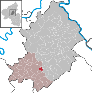
| Location of the local community Rödern in the Rhein-Hunsrück district | ||
  |
||


Rödern is a municipality in the Rhein-Hunsrück district in Rhineland-Palatinate . It belongs to the Kirchberg (Hunsrück) community .
geography
The rural residential community Rödern is centrally located in the Hunsrück , to the west of it on a ridge the town of Kirchberg and to the east the Kauerbachtal . The district covers an area of 2.72 km², of which 1.27 km² is forest.
history
Since the 12th century the area was part of the County of Sponheim . The first written mention of the place as Imzinruden took place in 1317. The place came into the possession of the margraves of Baden in the 18th century . With the occupation of the left bank of the Rhine in 1794 by French revolutionary troops , the place became French, in 1815 it was assigned to the Kingdom of Prussia at the Congress of Vienna . After the First World War temporarily occupied by the French, the place has been part of the state of Rhineland-Palatinate since 1946.
politics
Municipal council
The council in Rödern consists of six council members, who in the local elections on May 26, 2019 in a majority vote were elected, and the honorary mayor as chairman.
mayor
The local mayor of Rödern is Josef Winn. In the local elections on May 26, 2019, he was confirmed in his office with 72.03% of the votes.
coat of arms
|
|
Blazon : “A curved golden tip in blue, inside a black mill wheel. A silver spade and a silver hoe tipped in front and crossed at an angle. In the back a silver raven. " |
| Justification of the coat of arms: The colors gold and blue indicate that it belongs to the Vordere Grafschaft Sponheim. The hoe and spade remind of the development of the village as a clearing settlement and interpret the name of the place. The raven refers to the Junkers von Koppenstein , who were tithe owners and fiefdoms of the Lötscher Mühle. The mill wheel refers to the two important mills in the area of Schneidemühl and Lötscher Mühle. |
Economy and Infrastructure
traffic
Rödern is part of the Rhein-Mosel transport association . The bus lines 644, 661 and 664 of the Rhein-Mosel Verkehrsgesellschaft connect the village with the neighboring towns of Kirchberg and Simmern . The nearest train station with passenger traffic is Kirn on the Nahe Valley Railway , 25 kilometers south.
The well-developed federal highway 50 Bitburg - Bingen am Rhein runs on the northern edge of the municipality, about one kilometer from the town center . You can use it to reach the next motorway junction, Rheinböllen on the A 61 , 20 kilometers to the east.
Web links
- Interesting facts about the local community Rödern
- Literature about Rödern in the Rhineland-Palatinate State Bibliography
Individual evidence
- ↑ State Statistical Office of Rhineland-Palatinate - population status 2019, districts, communities, association communities ( help on this ).
- ^ The Regional Returning Officer RLP: Municipal Council Election 2019 Rödern. Retrieved October 7, 2019 .
- ↑ The regional returning officer RLP: direct elections 2019. see Kirchberg, Verbandsgemeinde, 29th line of results. Retrieved October 7, 2019 .
- ↑ Description of the coat of arms Rödern

Bärenbach | Belg | Büchenbeuren | Dickenschied | Dill | Dillendorf | Gehlweiler | Gemünden | Rooster | Hedges | Heinzenbach | Henau | Hirschfeld (Hunsrück) | Kappel | Kirchberg (Hunsrück) | Kludenbach | Laufersweiler | Lautzenhausen | Lindenschied | Maitzborn | Metzenhausen | Low cost | Low ears | Niederweiler | Upper cost | Raversbeuren | Reckershausen | Rödelhausen | Rödern | Rohrbach | Conclusion | Blacks | Sohren | Sohrschied | Death Red | Unzenberg | Wahlenau | Womrath | Woppenroth | Würrich

Alterkülz | Altweidelbach | Argenthal | Badenhard | Bärenbach | Belg | Belgweiler | Bell (Hunsrück) | Beltheim | Benzweiler | Bergenhausen | Bulging | Bickenbach | Beavers | Birkheim | Boppard | Braunshorn | Bubach | Book | Büchenbeuren | Budenbach | Damscheid | Dichtelbach | Dickenschied | Dill | Dillendorf | Dommershausen | Dörth | Ellern (Hunsrück) | Emmelshausen | Erbach | Fronhofen | Gehlweiler | Gemünden | Gödenroth | Gondershausen | Rooster | Halsenbach | Hasselbach | House Bay | Hedges | Heinzenbach | Henau | Hirschfeld | Hollnich | Holzbach | Horn | Hungenroth | Kappel | Karbach | Kastellaun | Keidelheim | Kirchberg (Hunsrück) | Kisselbach | Klosterkumbd | Kludenbach | Korweiler | Kratzenburg | Külz (Hunsrück) | Kümbdchen | Lahr | Laubach | Laudert | Laufersweiler | Lautzenhausen | Leiningen | Liebshausen | Lindenschied | Linger Hahn | Maisborn | Maitzborn | Mastershausen | Mengiffer | Mermuth | Metzenhausen | Michelbach | Mörschbach | Mörsdorf | Morshausen | Mill path | Mother difference | Nannhausen | Neuerkirch | Ney | Low cost | Niederburg | Niederkumbd | Low ears | Niedert | Niederweiler | Norath | Upper cost | Oberwesel | Ohlweiler | Oppertshausen | Perscheid | Pfalzfeld | Pleizenhausen | Ravengiersburg | Raversbeuren | Rayanders | Reckershausen | Empire | Rheinböllen | Riegenroth | Riesweiler | Rödelhausen | Rödern | Rohrbach | Roth | Sankt Goar | Sargenroth | Conclusion | Schnorbach | Schönborn | Torrent | Blacks | Simmern / Hunsrück | Sohren | Sohrschied | Expense red | Steinbach | Thörlingen | Tiefenbach | Death Red | Uhler | Unzenberg | Urbar | Utzenhain | Wahlbach | Wahlenau | Wiebelsheim | Womrath | Woppenroth | Würrich | Wüschheim | Zilshausen