
Wellington
|
Wellington Wellington City Māori: Te Whanganui-a-Tara |
|
| Geographical location | |
 Wellington City location |
|
| Photo from Wellington | |
 City of Wellington view |
|
| Local authority | |
| Country | New Zealand |
| island | North island |
| region | Wellington |
| Local authority | City |
| Council | Wellington City Council |
| mayor |
Justin Lester New Zealand Labor Party |
| founding | 1839 |
| Post Code | 6011-6443 |
| Telephone code | +64 (0) 4 |
| UN / LOCODE | NZ WGN |
| Website | www.wellington.govt.nz |
| presentation | |
 coat of arms |
|
| Motto | Absolutely Positively ( Absolutely positive ) |
| nickname | Windy City ( Windy City ) |
| geography | |
| Region ISO | NZ-WGN |
| Coordinates | 41 ° 17 ′ S , 174 ° 47 ′ E |
| Highest elevation | 537 m |
| Lowest point | Height of sea level |
| surface | 290 km 2 |
| Residents | 190 959 (2013) |
| Population density | 658.48 inhabitants per km 2 |
| Statistical data | |
| Public revenue | NZ $ 412.0 million (2015) |
| Public expenditure | NZ $ 425.8 million (2015) |
| Number of households | 77 466 (2013) |
| Ø income | 37,900 NZ $ (2013) |
| Māori population | 7.6% (2013) |
Wellington , official name: Wellington City ( Māori Te Whanganui-a-Tara , and thus the Wellington Harbor and its surroundings is meant), the capital of New Zealand and, together with the neighboring cities of Lower Hutt , Upper Hutt and Porirua to Auckland to second largest metropolitan area in the country. The city of Wellington itself has around 190,000 inhabitants.
Origin of name
Wellington was named after Arthur Wellesley, 1st Duke of Wellington . The Māori designation Te Whanganui-a-Tara refers to the adjacent Wellington Harbor and translates as "The great port of Tara", while Pôneke is just the transcribed version of " Port Nick ", the earlier name for the city. Due to its location - Wellington is exposed on the southern tip of the North Island - the city offers attack surface for strong wind currents and downdrafts, hence the nickname: " Windy City " (Windy City) .
geography
Geographical location

Wellington City is on the southern end of the North Island. The city and has a pure land area of 290 square kilometers belonged to the Census in 2013 190,959 inhabitants. This makes the city the second smallest of the four independent cities in the Wellington region in terms of area, but with 658.7 inhabitants per km² it is the city with the third highest population density in the country, behind Hamilton and Tauranga .
In the north and northeast of the city, the urban areas of Porirua City and Hutt City form the border, in the west the coastline of the Tasman Sea , in the south the coastline of Cook Strait and in the east of Wellington Harbor . The western part of the city is characterized by a mountain landscape, which culminates in the 537 m high Outlook Hill at the southern tip.
The areas in the west of the built-up area of Wellington rise relatively steeply to a hilly low mountain range, so that the districts located there are sometimes a lot higher than the city center. Wellington is often compared to San Francisco because of its geographic nature . Mount Victoria , located south of the city center, is a popular lookout point and one of the city's most distinctive geographic features. The Miramar Peninsula ( Spanish ; lake view ) forms the easternmost point of the city. The city's international airport is located on the isthmus leading to this peninsula, and directly to the east of this peninsula is the entrance to Wellington Harbor with the notorious Barrett Reef , which has already killed numerous ships. The Wahine , which sank on the reef in 1968 and killed 52 people, is probably the best-known victim. In the natural harbor itself there are the three islands Matiu / Somes Island , Ward ( Makaro ) and Mokopuna , of which only the first is inhabited. In the north one of the great rivers of the North Island, the Hutt River, flows into the bay. In its valley, the Hutt Valley , are the cities of Upper Hutt in the north and Lower Hutt south of it. The two cities are bordered to the west by the mountains of the Akatarawa Forest as the foothills of the Tararua Range and to the east by the Remutaka Range .
Classification of the neighboring cities
Often the neighboring cities of Porirua City , Upper Hutt City and Hutt City are mistakenly viewed as part of Wellington , but are independent cities with their own City Council (City Council). From an economic point of view and from the point of view of the number of inhabitants and the population density, one could speak of a coherent metropolitan area Wellington , especially since public institutions, the economy, the infrastructure and public and political life are oriented towards Wellington as the capital.
geology
Wellington has an active geological fault through it. Not far from today's city center, the lighter, thick Australian plate pushes over the thinner but heavier Pacific plate . The movements of these two plates create three major geological faults that run either through or near the city: the Ohariu Fault , the Wairarapa Fault, and the Wellington Fault , all of which are causes of earthquakes in the area. The Wellington Fault runs straight through downtown Wellington from the Hutt Valley . Because of the frequent and the danger of major earthquakes in and around Wellington , the city developed into one of the world's leading centers for the investigation of geological plate displacement.
Numerous earthquakes have already changed the landscape in and around Wellington in recent years. After an earthquake in 1400, the ground on both the west and east coast was lifted by up to three meters, which completely changed the entire course of the coast.
The Wairarapa earthquake of 1855 , which raised the floor of the city towards the Remutaka Range by up to 6.4 m, generated a tsunami up to 10 m high and, with a strength of 8.2 W M, is considered the strongest earthquake in New Zealand on land since the earthquake was recorded.
climate
Wellington is located in the temperate climate zone . The city's nickname, Windy City , says a lot about the city's climatic conditions. The exposed location ensures strong wind currents. In addition, Wellington is the only capital in the world that is within the sphere of influence of the Roaring Forties ( German : Thundering Forties ). The term “ roaring forties ” describes a zone of strong westerly wind drifts between 40 ° and 50 ° south latitude . Despite this special location, severe storms only occur in autumn and winter.
| Wellington | ||||||||||||||||||||||||||||||||||||||||||||||||
|---|---|---|---|---|---|---|---|---|---|---|---|---|---|---|---|---|---|---|---|---|---|---|---|---|---|---|---|---|---|---|---|---|---|---|---|---|---|---|---|---|---|---|---|---|---|---|---|---|
| Climate diagram | ||||||||||||||||||||||||||||||||||||||||||||||||
| ||||||||||||||||||||||||||||||||||||||||||||||||
|
Average monthly temperatures and rainfall for Wellington
Source: MetService
|
|||||||||||||||||||||||||||||||||||||||||||||||||||||||||||||||||||||||||||
Overall, the sun shines more often and longer in Wellington than in Auckland or Melbourne , both of which are more north and therefore closer to the equator . There are over 2035 hours per year; in addition, it rains less than in Sydney or Auckland . The average amount of precipitation per year is around 1251 mm, although it usually rains more in winter, i.e. from May to August, than in summer. Average January temperatures fluctuate between 13.3 ° C (average minimum) and 20.6 ° C (average maximum), while average temperatures in July range between 5.6 ° C and 11.7 ° C.
history
Early settlement
The earliest name for the area around today's Wellington is " Te Upoko o Te Ika a Maui " ( English : the Head of Maui's fish ) or "The head of Maui's fish". The term is derived from the fish-like shape of New Zealand's North Island. This area has always been something special, as the "head of a fish" is worth more than the rest according to the customs of the Māori . Modern archaeological finds and investigations on the bones of the Pacific rat (Polynesian name: Kiore) with the help of the Radiocarbon dating documents the arrival of the Polynesians in New Zealand around the year 1280 AD. The region around Wellington is considered to be the first settlement area in the country alongside the Far North District .
According to Māori mythology , the hero Māui was given the honor of catching a large fish that now forms New Zealand's North Island, while his canoe represents the South Island. It goes on to say that Wellington Harbor on one side and Lake Wairarapa on the other are the eyes of the fish. The mouth is represented by Palliser Bay , while Cape Palliser and Turakirae Head represent the outermost jawbones. The Remutaka Range , Tararua Range and the Ruahine Range represent the backbone of the fish.
Apart from these myths of origin, the Polynesian explorer Kupe is believed to be the first person to set foot on the area around what is now Wellington in the 10th century AD, according to Māori legends . After naming a few islands, he returned to his homeland, the Polynesian archipelago, without "colonizing" the area. A few years later, a great Māori leader named Whatonga sent his two sons Tara and Tautoki south from the Mahia Peninsula on Hawke Bay . After the two had reached today's Wellington Harbor , they built a first settlement on the Miramar Peninsula ( Spanish : lake view ). Their descendants founded numerous up-and-coming tribes (e.g. Ngāti Tara , Ngāti Apa or Ngāti Ira ). The name Tar is immortalized in numerous geographical names, so Wellington Harbor has been called " Te Whanganui a Tara " (English: the great Harbor of Tara ), which is now also the official Māori -Name of the city is. The name Tararua Range also testifies to this time. After Waikato tribes had expelled the Ngāti Toa and Te Ati Awa tribes in 1819 , they migrated on towards Wellington . As a result, there were armed conflicts with the local tribes.
European settlement

At the time of the first European explorers of the area by Abel Tasman in 1642 and by James Cook in 1770, the waterfront areas at Wellington Harbor were littered with small Māori settlements, called in Māori Pā . Although both seafarers wanted to dock on land and explore the area, their first attempts failed because of the extremely strong current in the Cook Strait and its difficult wind conditions. Almost 70 years later, the first planned settlement by Europeans began when William Wakefield acquired large areas of land from the Māori on behalf of the New Zealand Company, founded in New Zealand in 1838 . As Wakefield in August 1839 his ship, the Tory , in the "great harbor of Tara " arrived, the formerly dominant played Māori - tribe Ngāti Tara not matter much, since he distinguished from the tribe of Te Ati Awa had been displaced. The latter supported the Europeans in their endeavors to build a settlement at the natural harbor called Port Nicholson by the Europeans , because in return they hoped for support from the Europeans against the warring Ngāti Toa tribe. In exchange for 100 muskets , 100 blankets, 60 red night caps, a dozen umbrellas and various little things, they left their country to the Europeans.
In the following year, 1840, the first settlers under the leadership of Wakefield reached Port Nicholson and named the future settlement in honor of Arthur Wellesley, 1st Duke of Wellington , a supporter of the New Zealand Company , Wellington . They established their first settlement in Petone in the estuary of the Hutt River . Due to frequent flooding, however, they were forced to move the village further to the southwest, to Lambton Harbor in what is now Thorndon . In 1846 Wellington already had a population of almost 4,000. A few years later it became clear that the city's narrow location did not allow any further growth. Therefore, the decision was made to drain large areas of the adjacent natural harbor. Before the work could even begin, an earthquake shook the region. On January 23, 1855, the Wairarapa earthquake changed the landscape in and around Wellington. With a thickness of 8.2 M W of the ground around was raised up to 6.4 m, in the harbor basin ( Wellington Harbor yet m) between 0.3 and 2. The land reclamation was used for the city center and later for the construction of the airport. The faults also shifted the sea shore, which means that Lambton Quay is now over 250 meters from the harbor basin.
From the monotonous capital to the cultural metropolis
Against all odds, such as earthquakes, major fires and regularly blowing gale force winds the paltry settlement developed with several dozen residents into a thriving center for the - and export with an important harbor. In 1865 Wellington officially became New Zealand's capital; their relocation from Auckland, which was already much larger at that time, to the centrally located, up-and-coming metropolis at Port Nicholson was considered necessary to prevent the secessionist efforts on the South Island, which were burgeoning in Otago due to the gold rush in Otago .

The first session of Parliament took place in Wellington on July 7, 1862 , but Wellington was not declared capital until November 1863, following a motion from Alfred Domett , which stated: “It has become necessary to move the seat of government ... in a convenient location in the Cook to shift road ". In 1886 the settlement received city rights. The former government building ( Old Government Building ) built in 1876 is the second largest wooden building in the world after the Tōdai-ji in Japan . That by the year 1979, completed Beehive (German: beehive ), in which the government offices are located, quickly became a symbol of the city.
With the advancement of the shipping industry, numerous large warehouses and production facilities in the port area were no longer required. Many halls were modernized and from then on served other purposes (museum, shopping complex, apartments or offices); others were demolished and turned into parks. In April 1968, the car ferry Wahine sank in a storm off the coast of Wellington . The shipwreck, which cost 53 lives, is considered to be the worst shipping disaster in the country's history, even though previous shipwrecks had higher casualties. In the 1980s, large parts of the city were rebuilt or rebuilt and most of the buildings were adapted to today's earthquake safety standards. The city center was further enhanced in 1998 with the opening of the Museum of New Zealand Te Papa Tongarewa , numerous other museums and the Westpac Stadium in 2000. It was not until 2006 that the Wellington waterfront was enriched by the newly designed Waitang Park .

Over the years Wellington has transformed from a small, sleepy state capital into an important cultural and lifestyle metropolis in the country. In addition to the numerous museums and theaters, a lively music and film scene also contributes to this. On 1 December 2003 was the third part of the film trilogy The Lord of the Rings in Wellington he Embassy Theater premiered. The event caused the greatest crowds in the city's history, with an estimated 100,000 people attending.
population
Population development
In 2013 Wellington had 190,959 inhabitants and compared to the 2006 Census recorded a 6.4% increase in population of around 11,500. Compared to 2001, the increase was even 9.5%. This development was similar in the neighboring urban districts of Porirua (51,717) with 6.5% and in Upper Hutt (40,179) with 4.6%. Only Lower Hutt (98,238) kept its population almost constant with an increase of only 534 inhabitants.
Of the 190,959 residents of Wellington , 14,433 residents were of māori origin (7.6%). This means that 2.4% of the country's Māori population lived in the city.
The median income in the population in 2013 was NZ $ 37,900 , compared to NZ $ 28,500 national average.
Origin and languages
Wellington is a multicultural capital with a population of 30.7% of people who were born overseas. Most of the city's residents feel they belong to the European ethnic group. The proportion of the country's actual indigenous people, the Māori , is below average, as is the proportion of people from the Pacific island states . In contrast, the proportion of people from Asia is a good 4% higher than the national average.
The exact results of the 2013 census for Wellington :
- 76.4% of the population belonged to the European population group (74.0% throughout New Zealand)
- 7.9% of the inhabitants of the Māori population group (14.9%)
- 4.9% of the population of the Pacific population (7.4%)
- 15.7% of the residents of the Asian population group (11.8%)
- 4.3% of residents to other population groups (2.9%).
Note: in New Zealand you can belong to several ethnic groups.
30.7% of the population said they were born overseas. The second most widely spoken language in Wellington is French, which is spoken by 3.1% of the population. The Māori language is spoken by 19.4% of the Māori .
Religions

The initially predominantly British settlers brought their religion, the Anglican Church , to the region around Wellington , which is now the seat of one of the seven dioceses of the Anglican Church in Aotearoa, New Zealand and Polynesia . The descendants of the first settlers built Old Saint Paul's Church in 1855 , one of the first church buildings in the area.
Due to constant immigration from Catholic countries, the Catholic denomination has displaced the Anglican denomination from number one in Wellington. The city is the seat of the Archdiocese of Wellington , to which the other Catholic dioceses in the country are subordinate as suffragan dioceses . The first cathedral, built in 1850, was replaced by today's neoclassical Sacred Heart Cathedral in 1901 .
There are also numerous other Christian denominations, such as the Lutheran Church .
Although Christianity is the largest religious group, there are many followers of other religions such as Buddhism , Hinduism or Islam . The latter group now operates three Islamic centers in the region in and around Wellington . Two Jewish communities are also represented, an Orthodox with around 200 registered people (as of 2010) and a liberal one comprising around 150 families (as of 2010) .
politics
City structure and administration
Wellington City is divided into 62 different districts, which in turn are combined into five so-called ward s (administrative units). Listed from west to east and from north to south are:

| Item | Northern Ward | Onslow-Western Ward | Lambton Ward | Southern Ward | Eastern Ward |
|---|---|---|---|---|---|
1 |
Ohariu | Makara Beach | Thorndon | Owhiro Bay | Roseneath |
2 |
Tawa | Makara | Pipitea | Bird Town | Hataitai |
3 |
Takapu Valley | Karori | Kelburn | Mornington | Kilbirnie |
5 |
Churton Park | Broadmeadows | Wellington Central | Kingston | Melrose |
6th |
Glenside | Ngauranga | Highbury | Newtown | Lyall Bay |
7th |
Grenada North | Khandallah | Aro Valley | Berhampore | Houghton Bay |
8th |
Grenada Village | Ngaio | Te Aro | Island Bay | Rongotai |
9 |
Paparangi | Kaiwharawhara | Oriental Bay | Southgate | Maupuia |
10 |
Woodridge | Crofton Downs | Mount Victoria | Miramar | |
11 |
Horokiwi | Wadestown | Brooklyn | Strathmore Park | |
12 |
Johnsonville | Wilton | Mount Cook | Moa Point | |
13 |
Newlands | Northland | Breaker Bay | ||
14th |
Karaka Bays | ||||
15th |
Seatoun |
Source: Wellington City Wards: 2013–2016 Triennium
The Northern Ward , Onslow-Western Ward , Lambton Ward and Eastern Ward each send three and the Southern Ward two Councilors to the City Council , which they form together with the Mayor . The mayor and the fourteen councilors are re-elected every three years.
Town twinning
-
 Sydney ( Australia )
 -
 Beijing ( People's Republic of China )
 -
Xiamen , Fujian Province ( People's Republic of China )
-
 Sakai ( Japan )
 -
 Harrogate ( United Kingdom )
 -
 Chania , Crete ( Greece )
economy

Wellington is defined more than any other city by the Central Business District . The New Zealand Stock Exchange (NZX) is located near the port area. In a ranking of the most important financial centers worldwide, Wellington was in 44th place (as of 2018). Numerous state and private companies have their headquarters in the city, including Telecom New Zealand , Radio New Zealand , the New Zealand Post and the Bank of New Zealand . Hell Pizza was founded in 1996 in Wellington .
In 2009, between 4,300 and 5,380 people were employed in the cultural sector, accounting for 3.1% of the city's workforce and 2.3% of the Wellington region .
Almost 2,000 people work for the clothing industry in over 400 companies. Almost 2,000 computer companies, including international giants such as Hewlett-Packard and IBM , are located in the region and employ over 11,000 people, which is 23% of all employees in the New Zealand IT sector. In the manufacturing industry, 15,000 people work in 1,600 companies. Major companies are here, for example, Fraser Engineering , Formway , metal . In biotechnology , which is an important and emerging factor for the region, 400 people work. Several Crown Research Institutes (CRIs), such as the Institute of Environmental Science & Research , the National Institute of Water and Atmospheric Research , Landcare Research New Zealand and the New Zealand Forest Research Institute conduct their research here.
Infrastructure
traffic
Local transport
The public transport in Wellington and its adjacent cities using the three transport bus , train and ferry . Since 2006, these transport media have appeared under a common name, similar to those in the greater Auckland area : Metlink . It is true that the ferries are still operated by different companies than the trains, and there are even different operators for the buses; but now all public transport in Wellington is unified under one umbrella organization. Wellington has the highest percentage of public transport users in New Zealand. Every weekday, approximately 26,000 people arrive in downtown Wellington by bus or train and an average of 28% of all movements are made by public transport, compared to Auckland (18%) and Christchurch (9%).
Road traffic

The road network in Wellington also had to be adapted to the difficult geographic conditions. Access roads to the suburbs away from the city center wind into the increasingly hilly areas and inevitably adapt to the hill lines. A single motorway is generally responsible for connecting Wellington city center to Porirua and the Hutt Valley : the largely six-lane Wellington Motorway , which runs along the geological fault between Wellington Harbor and the ridges until it merges into the Porirua Motorway and the Westerns Hutt Road splits up. The former belongs - like the Wellington Motorway - within the State Highway network to New Zealand State Highway 1 , the country's most important road link, which crosses the Pacific state from north to south.
There have been plans since the 1960s to better connect the districts south of the city center to the national road network. However, this project dragged on over several decades; In the meantime, the project to build a motorway has been abandoned, but with the Inner City Bypass, which has been under construction since 2005, a four-lane alternative is being implemented, which occasionally triggered violent protests.
Bus transport
Bus transport is the main form of public transport in Wellington . The extensive bus network covers almost all suburbs of the metropolitan area. The largest operator, Stagecoach , offers some special connections: The Flyer offers a fast connection from the airport via Wellington city center to Upper Hutt and the Stadium Shuttle brings sports fans from all parts of the Central Business District (CBD) to the WestpacTrust Stadium near the train station. Both lines were able to establish themselves as the transport needs in these areas can only be met to a limited extent by the suburban railway. The closure of the extensive tram network in 1964 resulted in the introduction of trolleybuses , of which around 60 were still in service in 2006. Trolleybus operations were discontinued at the end of October 2017.
Rail transport
Local transport

Wellington has a rapid transit network that does not fully meet the S-Bahn criteria , which is also the only electrified local rail network in the country. It consists of five lines on four routes, which lead in the north over the city of Porirua beyond the administrative seat of the Kapiti Coast District , Paraparaumu to Waikanae , and in the northeast past Lower and Upper Hutt to Masterton . All lines originate at Wellington Railway Station , which is slightly north of the city center. Although the system is more efficient and frequented than Auckland and even many American cities, almost no money has been invested in the network and trains since the 1960s. In 1983, the section to Paraparaumu was electrified and then every now and then new park-and-ride areas were created or old station buildings were modernized. With the closure of the tram, rail traffic in the metropolitan area suffered a further damper. A “survivor” of the wave of closings of the historic rail lines was the Wellington Cable Car , which today is almost only of importance for tourism and is now even a symbol of the city on the Cook Strait . There are four stations on the 600 meter long track, starting at Lambton Quay ; The final stop is the Wellington Botanic Gardens .
In the course of the modernization of the entire harbor district in the early 1990s, plans were made for a “museum tram” along the shore, similar to the one in Christchurch . After the election of a new city administration, these plans failed again. Another necessary project to better connect the southern parts of the city and in particular the airport is the construction of a light rail line from the main station. For the time being, however, both projects will not be pursued by the authorities.
Long-distance transport
Long-distance passenger transport by train has a long tradition in New Zealand - passenger trains have been running regularly on the North Island Main Trunk between Auckland and Wellington since 1908 - but it is a far lower priority than road traffic. Before 2008 the rails belonged to the state, but the operation was subject to the transport company Toll Rail , which decided on July 25, 2006 to discontinue the long-distance connection, which is steeped in tradition, known as the Overlander . After violent protests and a movement by the Green Party of Aotearoa New Zealand , the company decided to continue the connections in a reduced manner. Another company, the Manning Group, showed interest in a future connection. Due to the prospect that passenger traffic on New Zealand's rails will not be secured in the long term in private business, the then Labor government decided to act under Prime Minister Helen Clark . Since 2008, the operation of the railway has been completely in state hands again after the company Toll Rail was nationalized and renamed Kiwi Rail . Kiwi Rail provides all rail passenger services in New Zealand (with the exception of the Auckland suburbs operated by Veolia ).
Air traffic

The airport Wellington was opened in 1959 and is located just five kilometers southeast of the city center on the Miramar Peninsula . He thus relieved the airfield in Paraparaumu , which today is mostly only used for private flights and nearby domestic connections. In the east and west it is surrounded by residential and commercial areas, in the south the Pacific Ocean joins directly , while the airport area in the north is only separated from the natural harbor by a highway . Despite this restricted location, it is the third largest in the country in terms of passenger volume after Auckland Airport and Christchurch Airport and transports over 4.5 million people per year. Most flight movements are domestic flights, which are mainly served by Air New Zealand and smaller airlines. In addition, flights to neighboring Australian cities and Fiji are also offered - mainly through JetConnect , a subsidiary of Qantas Airways . An important argument against the airport near the city center is that the runway is less than two kilometers long. There are plans for an extension, but without the support of a major airline, it seems unlikely that it will be realized anytime soon.
Ferry traffic

The ferry connection between the north and south islands has an important share in long-distance traffic . Two companies offer sea passages between Wellington and Picton and thus bridge the Cook Strait , a strait with sometimes very rough conditions. The larger ferry company of the two is Interislander , with around 1,000,000 passengers, 230,000 vehicles and around 5,700 trips per year . The smaller company is called Bluebridge . Within Wellington Harbor , ferries run from Wellington to Eastbourne in the east, Petone in the north and Matiu / Somes Island .
Education
Public education is of a good standard in Wellington . The Victoria University of Wellington has six faculties and over 20,000 students the largest educational institution in the city. The Massey University operates in Wellington own campus and is active in the fields of economy, Creative arts, humanities and research.
Both universities also operate a joint music academy (NZSM), which was created in 2005 from the merger of the music academies of Victoria and Massey Universities. The University of Otago in Wellington , which was founded in 1971, is used to teach medicine and conduct research, including examining respiratory diseases.
In Wellington there are seven other state institutions in addition to a private school, the largest of which are Wellington College, founded in 1867 with over 1,500 students, and Wellington High School, founded in 1905, with around 1,100 students.
Culture
Wellington is considered the country's cultural and artistic center. In a study by Mercer Consulting on the quality of life in selected cities, Wellington ranked 15th in 2018 and ranks third among the most livable cities in the southern hemisphere after Auckland and Sydney .
An extremely popular meeting point near the Museum of New Zealand Te Papa Tongarewa is Oriental Bay , whose beach in the middle of the city is ideal for swimming.
Film and entertainment
The city is the center of the New Zealand film industry . Based on Hollywood , the most important location for the American film industry, Wellington is now often referred to as Wellywood . Its nickname the city since the world premiere of The Lord of the Rings: The Return of the King in 2003. In addition to Peter Jackson and a few others were as Richard Taylor and Jamie Selkirk involved in the district of Miramar on the peninsula in the south of Wellington's one to create a great center for the film industry. For a few million dollars were movie studios , sound studios and facilities for pre - and post production built, the largest of the Weta Workshop is. Jane Campion and Vincent Ward are very important to the city's film scene . Young personalities like Costa Botes ( Forgotten Silver ), Taika Cohen ( Tama tu ) or Jennifer Bush-Daumec ( Lands Of Our Fathers ) contribute to the cinematic diversity of “ Wellywood ” to an ever greater extent .
Also because of several universities and the associated number of students, the city exudes a young, relaxed flair, which is reflected, for example, in the musical diversity or the varied nightlife .
The best-known bands from Wellington are The Phoenix Foundation , Shihad , Steriogram , Fat Freddy's Drop and The Black Seeds . Wellington is home to the State Symphony Orchestra and Ballet and numerous theaters, such as the St. James Theater , the Downstage Theater and the Bats Theater .
The Te Aro district has the largest entertainment district in New Zealand. There are five large cinema complexes and countless bars, clubs and cafes here. Wellington has more restaurant seats per capita than New York City .
Sports

Also in sports plays Wellington beyond the borders of New Zealand, a major role: The Hurricanes represent the city in the three-nation Super 15 -Cup , the Wellington Lions in the national rugby union championships National Provincial Championship (NPC), the Wellington Firebirds in cricket , the Wellington Orcas in rugby league , the Capital Shakers in netball , Wellington Phoenix in football (member of the Australian A-League since the 2007/2008 season ) and the Wellington Saints in the National Basketball League . Between 1985 and 1996, the road race for touring cars , known as the Wellington 500 , took place in downtown Wellington .
Attractions
Buildings / squares / parks
Well-known sights the older New Zealand Parliament building and the 1,979 completed government building, are Beehive (Beehive) called, in which the Prime Minister and the Minister of the Cabinet have their offices and meet the Cabinet; the historic Wellington Cable Car and the Botanical Garden, which is connected to the city , with a viewpoint above the Victoria University of Wellington ; the Old Government Building as the largest wooden building in the southern hemisphere (now the law school of the university) and Mount Victoria as one of the best viewpoints in the city. Old Saint Paul’s , the first Anglican cathedral , was built from 1855 as a wooden church in neo-Gothic forms. In 1964 their function was transferred to the newly built Cathedral of Saint Paul . Sacred Heart Cathedral, completed in 1901, is the episcopal church of the Roman Catholic Archdiocese of Wellington .
During the urban development around the beginning of the 20th century, a number of secular buildings were built, which help shape the image of the inner city. These include the Aida Pastry Shop and the Barber Building on Cuba Street , the Thistle Inn as one of the oldest pubs in New Zealand, the Albemarle Hotel on Ghuznee Street , the Antrim House in the middle of higher modern buildings, the Alcohol and Drug Dependence Center Building , the Appraisal House in Willis Street , the Ashleigh Court Private Hotel and the Aqua Vitae Bottle Store , as rare evidence of early colonial development.
Museums
Wellington can boast a wide range of museums, ranging from the award-winning Museum of New Zealand Te Papa Tongarewa , which opened in 1998 , the National Library of New Zealand , the Hyde Park Museum , which deals with the history of the city, the Museum of Wellington City & Sea , which sheds light on the city's maritime origins, as well as many others, including the Film Center . With an event known as SUMMER '79 in 1979, the transformation of the once sober capital into a festival-rich cultural metropolis began. Today the International Festival of the Arts is held every two years and every year the famous Cuba Street Carnival , the Fringe Festival , Summer City , the New Zealand Affordable Art Show , the former Nelson- based World of Wearable Art Festival and countless other events held.
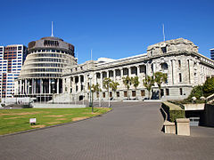
v. l. To the right: Bowen House , Beehive , Parliament House
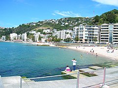
Part of the Oriental Bay
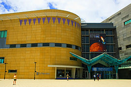
Museum of New Zealand Te Papa Tongarewa - National Museum of the country

Wellington Botanical Gardens

Pubs in the city center


Panoramas


Personalities
sons and daughters of the town
- Bob Scott (1921–2012), rugby union player
- Michael Hardie Boys (* 1931), lawyer and New Zealand's 17th Governor General from 1996 to 2001
- Paul Reeves (1932–2011), Minister of the Anglican Church and Governor General of New Zealand
- Dick Joyce (born 1946), rower
- Richard Curtis (* 1956), screenwriter of numerous British comedy series
- Wynton Rufer (* 1962), New Zealand-Swiss football coach
- Russell Crowe (* 1964), film actor, film director, film producer and musician
- Karl Urban (* 1972), actor
- Bret McKenzie (* 1976), actor, musician, comedian and Oscar winner
- Brooke Fraser (* 1983), pop / folk singer and songwriter
Personalities who have worked on site
- Alan MacDiarmid (1927-2007), chemist
- Lloyd Jones (* 1955), writer
- Neil Cross (* 1969), author and screenwriter
- Tana Umaga (born 1973), rugby union player
See also
literature
- Margaret Walsh Young, Susan L. Stetler : New Zealand - Major Cities . In: Gale Research Company (Ed.): Cities of the World . 2nd Edition. Volume 4 . Detroit, Michigan 1985, ISBN 0-8103-2059-2 , pp. 363-368 .
- Helga Neubauer: Wellington . In: The New Zealand Book . 1st edition. NZ Visitor Publications , Nelson 2003, ISBN 1-877339-00-8 , pp. 554-568 .
- Tom Brooking : The History of New Zealand . Greenwood Press , Westport, Connecticut 2004, ISBN 0-313-32356-9 .
- Philip M. Parker : The 2006 Economic and Product Market Databook for Wellington . ICON Group International , Las Vegas 2006, ISBN 0-497-81816-7 .
Web links
- Homepage . Wellington City Council,accessed October 7, 2014.
- Homepage . Greater Wellington Regional Council,accessed October 7, 2014.
- Homepage . Positively Wellington Tourism (PWT),accessed October 7, 2014(English, tourism website of the City of Wellington).
- Getting around . Greater Wellington Regional Council,accessed October 7, 2014(All About and About the Greater Wellington Region's Transportation Systems).
- Homepage . Te Papa Tongarewa - Museum of New Zealand,accessed October 7, 2014.
Individual evidence
- ↑ Mayor and Councilors . Wellington City Council , October 8, 2016, accessed May 23, 2019 .
- ↑ a b c d e 2013 Census QuickStats about a place : Wellington City - Population and dwellings . Statistics New Zealand , accessed July 4, 2016 .
- ↑ a b c d e Wellington City Council . In: Local Councils . Department of Internal Affairs , accessed July 4, 2016 .
- ^ First peoples in Māori tradition . Te Ara - the Encyclopedia of New Zealand , September 22, 2012, accessed October 9, 2014 .
- ↑ Edited by Patrick V. Kirch : Dating the late prehistoric dispersal of Polynesians to New Zealand using the commensal Pacific rat . In: The National Academy of Sciences (Ed.): PNAS . Volume 105, No. 22 . Washington June 3, 2008 ( online [accessed October 9, 2014]).
- ^ First peoples in Māori tradition - Kupe's location . Te Ara - the Encyclopedia of New Zealand , September 22, 2012, accessed October 9, 2014 .
- ^ Tom Brooking : The History of New Zealand . 2004, p. 46 .
- ↑ Phil Mercer : How hobbits Took over NZ's capital . BBC News , December 1, 2003, accessed October 10, 2014 .
- ↑ 2013 Census QuickStats about a place: Wellington City . Statistics New Zealand , accessed October 6, 2014 .
- ^ QuickStats About Wellington City (2006). Statistics New Zealand , accessed October 20, 2014 .
- ↑ 2013 Census QuickStats about a place: Pirirua City . Statistics New Zealand , accessed October 6, 2014 .
- ↑ 2013 Census QuickStats about a place: Upper Hutt City . Statistics New Zealand , accessed October 6, 2014 .
- ↑ 2013 Census QuickStats about a place: Lower Hutt City . Statistics New Zealand , accessed October 6, 2014 .
- ↑ a b 2013 Census QuickStats about a place: Wellington City - Ethnic groups . Statistics New Zealand , accessed October 20, 2014 .
- ↑ 2013 Census QuickStats about a place : Wellington City - Cultural diversity . Statistics New Zealand , accessed July 4, 2016 .
- ^ Wellington City Wards: 2013-2016 Triennium . (PDF 417 kB) Wellington City Council , accessed on July 4, 2016 (English).
- ^ Councilors . Wellington City Council , accessed July 4, 2016 .
- ^ Mark Yeandle : The Global Financial Centers Index 23 . Ed .: Z / Yen . March 2018, p. 4 (English, online [PDF; 3.1 MB ; accessed on May 23, 2019]).
- ↑ Tom Cardy : Can Wellington retain its arts capital title? . Dominion Post , May 19, 2001, accessed August 28, 2011 .
- ^ Crown Research Institutes . Crown Company Monitoring Advisory Unit (ccmau) , archived from the original on May 15, 2009 ; accessed on October 11, 2014 (English).
- ↑ In just a few weeks the last trolley bus will retire, as the era of the Wellington icon comes to an end. . In: Metlink . Greater Wellington Regional Council , August 7, 2017, accessed January 4, 2018 .
- ↑ Overlander saved . Newstalk , September 28, 2006, archived from the original on August 15, 2007 ; accessed on October 11, 2014 (English).
- ↑ Victoria at a glance . Victoria University of Wellington , accessed October 11, 2014 .
- ^ University of Otago Wellington . University of Otago , accessed October 11, 2014 .
- ^ The best cities in the world for environment and infrastructure . CityMayors , December 6, 2012, accessed September 28, 2014 .
North Island :
Auckland * |
Hamilton |
Lower Hutt |
Napier |
Palmerston North |
Porirua |
Tauranga |
Upper Hutt |
Wellington
South Island :
Christchurch |
Dunedin |
Invercargill |
Nelson *
Northland :
Far North District •
Kaipara District •
Whangarei District
Auckland Council (Unitary Authority)
Waikato :
Thames-Coromandel District •
Hauraki District •
Waikato District •
Matamata-Piako District •
Hamilton City •
Waipa District •
Otorohanga District •
Rotorua Lakes 40% •
Waitomo District 95% •
Taupo District 75%
Bay of Plenty :
Western Bay of Plenty District •
Tauranga City •
Opotiki District •
Whakatāne District •
Rotorua Lakes 60% •
Kawerau District •
Taupo District 10%
Gisborne District (Unitary Authority)
Hawke's Bay :
Wairoa District •
Taupo District 10% •
Hastings District •
Napier City •
Central Hawke's Bay District •
Rangitikei District 10%
Taranaki :
New Plymouth District •
Stratford District 70% •
South Taranaki District
Manawatu-Wanganui :
Taupo District 5% •
Waitomo District 5% •
Ruapehu District •
Stratford District 30% •
Rangitikei District 90% •
Whanganui District •
Manawatu District •
Palmerston North City •
Tararua District 97% •
Horowhenua D istrict
Wellington :
Tararua District 3% •
Masterton District •
Kapiti Coast District •
Carterton District •
South Wairarapa District •
Upper Hutt City •
Porirua City •
Hutt City •
Wellington City
Tasman District ( Unitary Authority )
Nelson City ( Unitary Authority )
Marlborough District ( Unitary Authority )
West Coast :
Buller District •
Gray District •
Westland District
Canterbury :
Kaikoura District •
Hurunui District •
Selwyn District •
Waimakariri District •
Christchurch City •
Ashburton District •
Mackenzie District •
Timaru District •
Waitaki District 55% •
Waimate District
Otago :
Queenstown-Lakes District •
Central Otago District •
Waitaki District 45% •
Dunedin City •
Clutha District
Southland :
Southland District •
Gore District 70% •
Invercargill City