
Arnsberg district
| coat of arms | Germany map | |
|---|---|---|

|
Coordinates: 51 ° 24 ' N , 8 ° 4' E |
|
| Basic data (as of 1974) | ||
| Existing period: | 1817-1974 | |
| State : | North Rhine-Westphalia | |
| Administrative region : | Arnsberg | |
| Regional association : | Westphalia-Lippe | |
| Administrative headquarters : | Arnsberg | |
| Area : | 662.08 km 2 | |
| Residents: | 150,900 (Dec. 31, 1973) | |
| Population density : | 228 inhabitants per km 2 | |
| License plate : | AR | |
| Circle key : | 05 8 32 | |
| Circle structure: | 56 municipalities | |
| District Administrator : | Rolf Füllgraben ( CDU ) | |
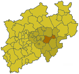
| Location of the Arnsberg district in North Rhine-Westphalia | ||
  |
||

The Arnsberg district was a district in the Arnsberg administrative district from 1817 to 1974 . With that he first belonged to the Prussian province of Westphalia and from 1946 to North Rhine-Westphalia . From 1953 to 1969 it was called the Arnsberg district. The district town was Arnsberg . In 1975, most of its territory went into the Hochsauerlandkreis .
geography
location
The Arnsberg district was in the north of the Sauerland .
Neighboring areas
In 1974 the Arnsberg district bordered clockwise in the north, starting with the Soest , Lippstadt , Meschede , Olpe , Lüdenscheid and Iserlohn districts .
history
The Arnsberg district was formed in 1817 in the Arnsberg administrative district of the Prussian province of Westphalia from the area of the old offices of Arnsberg, Eslohe, Meschede and Werl of the former Duchy of Westphalia . As early as 1819, the district structure in the Sauerland was fundamentally changed. The area around Eslohe and Meschede was added to the new Eslohe district, while the Werl area fell to the Soest district and the municipality of Wickede to the Hamm district . At the same time, a number of communities in the Soest and Iserlohn districts joined the Arnsberg district. In 1832 the places of the parishes Balve and Affeln from the Iserlohn district and the Wildewiese community from the Eslohe district changed to the Arnsberg district.
The circle was in the 1830s in the mayors Allendorf, Arnsberg, Balve, Light box, Hüsten and Warstein and the mayor districts divided Hirschberg and Freienohl. As part of the introduction of the rural community order for the province of Westphalia, the district was divided into the offices of Allendorf , Balve , Freienohl , Hellefeld, Hüsten and Warstein as well as the two non-official cities Arnsberg and Neheim in 1844 . As early as 1845, the Hellefeld office was dissolved again and divided between the Allendorf and Freienohl offices.
Between 1845 and 1974 there were the following changes in the administrative structure of the district:
- In 1905 the community of Dinschede was renamed Oeventrop .
- In 1906 the seat of the Allendorf office was moved to the city of Sundern in 1906 and the office was renamed to Sundern .
- In 1928 the Melschede manor district was incorporated into the Hövel community .
- In 1941 Neheim and Hüsten were merged to form the town of Neheim-Hüsten .
- In 1952 the community of Westenfeld moved from the Freienohl office to the Sundern office.
On October 1, 1969, the district became the Arnsberg district again .
The district was dissolved with effect from January 1, 1975 and most of its area was merged with that of the Meschede and Brilon districts to form the Hochsauerlandkreis . The town of Balve became part of the Märkisches Kreis together with the places of the former Balve office . The city of Warstein was united with the surrounding communities and added to the Soest district.
Population development

| year | Residents |
|---|---|
| 1818 | 24,147 |
| 1858 | 35,483 |
| 1871 | 36,936 |
| 1885 | 43,177 |
| 1905 | 58,762 |
| 1910 | 64,594 |
| 1925 | 73.079 |
| 1939 | 87,272 |
| 1950 | 115.118 |
| 1961 | 129,090 |
| 1970 | 146.020 |
| 1973 | 150,900 |
politics
District administrators
- Franz Anton Thüsing (1817–1832)
- Felix of Lilien (1835-1883)
- Joseph Freusberg (1885–1895)
- Franz Droege (1897–1913)
- Friedrich Gorius (1916) (substitute)
- Heinrich Haslinde (1916–1922; 1927–1933)
- Max Schencking (1922–1927)
- Heinrich Teipel (1933–1942)
- Udo Veltkamp (1943–1945)
- Fritz Dannapfel (1945)
- Andreas Vomfell (1945–1946)
- Friedrich Maas (1946)
- Bernhard Vogel (1946–1948)
- Johannes Kühling (1948–1956)
- Wilhelm Hertin (1956–1961)
- Karl Brüggemann (1961–1969)
- Ferdinand Tillmann (1969–1973)
- Rolf Füllgränke (1973–1974)
Upper District Directors
- Theodor Bönninghaus (1946–1962)
- Ernst Becker (1963–1973)
- Günter Cronau (1973–1974)
Reichstag elections 1920–1933
| year | DNVP | DVP | center | DDP | SPD / USPD | KPD | NSDAP | Otherwise |
|---|---|---|---|---|---|---|---|---|
| 1920 | 1.2 | 5.7 | 71.8 | 1.7 | 19.3 | 0.2 | 0.0 | 0.1 |
| 1924 (1) | 5.6 | 3.9 | 69.0 | 1.4 | 7.8 | 8.0 | 1.0 | 3.4 |
| 1924 (2) | 5.4 | 3.9 | 70.1 | 1.8 | 11.6 | 3.4 | 1.2 | 2.6 |
| 1928 | 3.8 | 3.4 | 60.4 | 1.4 | 15.4 | 2.5 | 1.4 | 11.7 |
| 1930 | 1.8 | 1.9 | 56.2 | 2.0 | 11.5 | 5.7 | 10.1 | 10.8 |
| 1932 (1) | 2.9 | 0.4 | 58.8 | 0.2 | 11.1 | 10.7 | 14.4 | 1.5 |
| 1932 (2) | 4.1 | 0.5 | 56.8 | 0.3 | 10.8 | 13.3 | 13.1 | 1.1 |
| 1933 | 4.9 | 0.4 | 54.6 | 0.2 | 10.4 | 8.5 | 20.8 | 0.2 |
Bundestag elections 1949–1965
| year | CDU | SPD | FDP | Cent. | Otherwise |
|---|---|---|---|---|---|
| 1949 | 43.7 | 25.1 | 5.0 | 17.3 | 8.9 |
| 1950 | 42.1 | 32.8 | 9.4 | 14.3 | 1.4 |
| 1953 | 59.3 | 24.2 | 6.4 | 5.6 | 4.0 |
| 1957 | 63.9 | 25.4 | 4.9 | 1.7 | 4.1 |
| 1961 | 59.5 | 29.3 | 9.2 | 0 | 1.5 |
| 1965 | 57.6 | 34.7 | 6.0 | 0 | 1.7 |
District elections from 1946
The list only shows parties and constituencies that received at least two percent of the votes in the respective election.
Share of votes of the parties in percent
| year | CDU | SPD | FDP | DZP | KPD |
|---|---|---|---|---|---|
| 1946 | 56.1 | 30.4 | 10.3 | 3.0 | |
| 1948 | 43.7 | 36.0 | 0.9 | 16.9 | 2.5 |
| 1952 1 | 44.8 | 29.1 | 8.8 | 13.0 | |
| 1956 | 48.8 | 33.2 | 8.3 | 9.3 | |
| 1961 | 56.0 | 29.9 | 8.6 | 5.3 | |
| 1964 | 54.5 | 34.3 | 6.4 | 4.8 | |
| 1969 | 56.1 | 37.3 | 5.9 |
footnote
1 1952: additionally: DP: 2.8%
Communities
Unofficial cities
- Arnsberg
- Neheim-Hüsten (until 1941 only Neheim )
Offices and associated communities
- Office Balve
-
Amt Freienohl
- Altenhellefeld
- Breitenbruch
- Freienohl , freedom
- Grevenstein
- Hellefeld
- Herblinghausen
- Linnepe
- Meinkenbracht
- Oeventrop (until 1905 Dinschede )
- Rumbeck
- Uentropic
- Visbeck
- Westenfeld (since 1952 in the Sundern office)
-
Office Hüsten
- Bachum
- Bruchhausen
- Real houses
- Enkhausen
- Estinghausen
- Hach , freedom
- Herringring
- Hövel
- Wood
- Hüsten (until 1941)
- Langscheid
- Müschede
- Low bucket
- Stamp
- Vosswinkel
- Wennigloh
- Melschede , manor district ( incorporated into Hövel in 1928 )
-
Office Sundern (until 1906 Office Allendorf )
- Allendorf
- Amecke
- Endorf
- Hagen
- Stockum
- Sundern , city
- Westenfeld (until 1952 in the Amt of Freienohl)
- Wild meadow
-
Warstein Office
- Allages
- Belecke , city
- Hirschberg , city
- Mülheim
- Visually
- Waldhausen
- Warstein , city
License Plate
On July 1, 1956, the district at that time was assigned the distinctive sign AR when the vehicle registration number was introduced. It was issued until December 31, 1974.
literature
- von Lilien: Statistics of the Arnsberg district. Arnsberg, 1875 digitized
Web links
- Michael Rademacher: German administrative history from the unification of the empire in 1871 to the reunification in 1990. Arnsberg district. (Online material for the dissertation, Osnabrück 2006).
Individual evidence
- ↑ Stephanie Reekers: The regional development of the districts and communities of Westphalia 1817-1967. Aschendorff, Münster 1977, pp. 177, 178.
- ↑ Westfalenlexikon 1832-1835 . In: Landschaftsverband Westfalen-Lippe (Ed.): Reprints for the Westphalian archive maintenance . tape 3 . Münster 1978 (reprint of the original from 1834).
- ↑ Landgemeinde -ordnung for the Province of Westphalia from October 31, 1841 (PDF; 1.6 MB)
- ^ Official Journal for the administrative district of Arnsberg 1844. Retrieved on February 2, 2014 .
- ^ Official journal for the administrative district of Arnsberg 1845, dissolution of the Hellefeld office. Retrieved February 22, 2014 .
- ↑ gemeindeververzeichnis.de: Arnsberg district
- ↑ Sauerland Heimatbund: Sundern, City with a Future ( Memento of the original from February 27, 2014 in the Internet Archive ) Info: The archive link has been inserted automatically and has not yet been checked. Please check the original and archive link according to the instructions and then remove this notice.
- ^ Archives in North Rhine-Westphalia: Archive Melschede
- ^ History of Westenfeld
- ↑ Announcement of the new version of the district regulations for the state of North Rhine-Westphalia from August 11, 1969 in the Law and Ordinance Gazette for the state of North Rhine-Westphalia, year 1969, No. 2021, p. 670 ff.
- ^ Federal Statistical Office (ed.): Historical municipality directory for the Federal Republic of Germany. Name, border and key number changes in municipalities, counties and administrative districts from May 27, 1970 to December 31, 1982 . W. Kohlhammer, Stuttgart / Mainz 1983, ISBN 3-17-003263-1 , p. 330 f .
- ↑ Source: respective issue of the State Statistical Office (LDS NRW), Mauerstr. 51, Düsseldorf, with the election results at the district level.

Before the founding of North Rhine-Westphalia in what is now North Rhine-Westphalia, the (rural) districts: Bilstein | Blankenheim | Bochum | Brakel | Frets | Dortmund | Duisburg | Düsseldorf | Elberfeld | Eslohe | Food | Geilenkirchen | Gelsenkirchen | Gemünd | Gimborn | Gladbach | Grevenbroich-Neuss | Gummersbach | Hagen | Hamm | Hattingen | Heinsberg (1816-1932) | Homburg | Hörde | Kempen | Krefeld | Lechenich | Lennep | Medebach | Mettmann | Mülheim am Rhein | Mülheim an der Ruhr | Neuss | Opladen | Rahden | Rheinbach | Rheinberg | Ruhrort | Schwelm | Solingen | Solingen-Lennep | Uckerath | Waldbröl | Wipperfürth
Former North Rhine-Westphalian (rural) districts: Aachen (1816–1971) | Aachen (1972–2009) | Ahaus | Altena | Arnsberg | Beckum | Bergheim (Erft) | Bielefeld | Bonn | Borken (1816–1974) | Brilon | Büren | Coesfeld (1816–1974) | Detmold | Dinslaken | Düren (1816–1971) | Düsseldorf-Mettmann | Erkelenz | Geilenkirchen-Heinsberg | Geldern | Grevenbroich | Halle (Westphalia) | Höxter (1816–1974) | Iserlohn | Jülich | Kempen-Krefeld | Cologne | Lemgo | Lippstadt | Lübbecke | Lüdenscheid | Lüdinghausen | Meschede | Minden | Moers | Monschau | Munster | Paderborn (1816–1974) | Rees | Rhein-Wupper-Kreis | Schleiden | Selfkantkreis Geilenkirchen-Heinsberg | Victories | Siegkreis | Soest (1817–1974) | Steinfurt (1816–1974) | Tecklenburg | Unna (1930–1974) | Warburg | Warendorf (1816–1974) | Wiedenbrück | Wittgenstein

Districts: Ahaus | Altena | Arnsberg | Beckum | Bielefeld | Bilstein | Bochum | Bark | Brakel | Brilon | Frets | Büren | Coesfeld | Dortmund | Ennepe-Ruhr district | Eslohe | Gelsenkirchen | Hagen | Halle (Westphalia) | Hamm | Hattingen | Herford | Hörde | Höxter | Iserlohn | Lippstadt | Lübbecke | Lüdinghausen | Medebach | Meschede | Minden | Munster | Olpe | Paderborn | Rahden | Recklinghausen | Schwelm | Victories | Soest | Steinfurt | Tecklenburg | Unna | Warburg | Warendorf | Wiedenbrück | Wittgenstein
City districts: Bielefeld | Bocholt | Bochum | Bottrop | Buer | Castrop-Rauxel | Dortmund | Gelsenkirchen | Gelsenkirchen-Buer | Gladbeck | Hagen | Hamm | Herford | Herne | Hörde | Iserlohn | Lüdenscheid | Lünen | Minden | Munster | Osterfeld | Recklinghausen | Victories | Wanne-Eickel | Wattenscheid | Witten