
Ladelund
| coat of arms | Germany map | |
|---|---|---|

|
Coordinates: 54 ° 50 ′ N , 9 ° 2 ′ E |
|
| Basic data | ||
| State : | Schleswig-Holstein | |
| Circle : | North Friesland | |
| Office : | Südtondern | |
| Height : | 20 m above sea level NHN | |
| Area : | 24.09 km 2 | |
| Residents: | 1334 (Dec. 31, 2019) | |
| Population density : | 55 inhabitants per km 2 | |
| Postal code : | 25926 | |
| Area code : | 04666 | |
| License plate : | NF | |
| Community key : | 01 0 54 073 | |
| LOCODE : | DE 72G | |
| Office administration address: | Marktstrasse 12 25899 Niebüll |
|
| Website : | ||
| Mayor : | Lutz Martensen | |
| Location of the municipality of Ladelund in the district of North Friesland | ||
  |
||

Ladelund is a municipality in the north of the district of North Friesland in Schleswig-Holstein .
geography
Geographical location
The municipality extends on the ridge of the Schleswig Geest . The northern municipal border also forms part of the federal border to Denmark . In earlier times Ladelund was part of the Karrharde administrative district .
The municipal area also includes Beckhuus (Danish Bækhus ), Boverstedt ( Boversted ), Kolonistenhäuser ( Kolonisthuse ), Königsacker ( Kongsager ), Ladelundfeld ( Ladelund Mark ), Ladelundmühle ( Ladelund Mølle ), Neuhaus ( Nyhus ) and customs houses ( Toldhuse ).
Neighboring communities
| Aabenraa municipality (DK) | ||
| Westre |
.svg)
|
Bramstedtlund |
| Karlum | Eight crew |
history
The first written mention is dated to the year 1352. The place name can be traced back to either Old Norse hlaða or Danish ark for a barn or Old Norse hlaði for a stick (from firewood or peat). The second ending -lund means grove or light wood in Danish .
In the autumn of 1944, the Ladelund concentration camp , a satellite camp of the Neuengamme concentration camp , was located near the village for six weeks . The Ladelund concentration camp memorial and meeting place was set up to commemorate the atrocities .
On January 1, 1970 Boverstedt was incorporated.
politics
Community representation
The municipal council has 13 seats. The election on May 6, 2018 had the following result: CDU six, SPD two, SSW two and the voter group WGL three seats. The last voter turnout was 57.9 percent.
coat of arms
The coat of arms was approved on April 14, 1966.
Blazon : "In gold a red göpel, accompanied on the left by a three-leaved blue oak branch, on the right by a blue clover leaf, below by three continuous blue wavy threads."
Ladelund, founded as a farming village, is first mentioned in 1552. The place name is of Danish origin, made up of the components "lade" meaning "barn" and "lund" meaning "forest". As a result, the oak branch is to be understood as a visual implementation of the place name. Like many other settlements in the country, Ladelund was created through clearing in the middle of a forest area. Fossil tree stumps uncovered during tillage are evidence of this. The shamrock in the coat of arms is a symbol of the rural use of the village hall. The soil that has been made arable for pastures and fields has been increased in its yield since the 19th century by the method of marl. Three lakes have emerged from Mergelkuhlen on the Feldmark, which are represented in the coat of arms by the three wave threads. Emerged as a by-product of soil cultivation, the lakes have a high recreational value today. The red Göpel is the stylized representation of a house gable and thus to be regarded as a farmhouse or, with regard to the place name, as a barn. The golden shield color emphasizes the agricultural structure and the crop yield. The color scheme as a whole indicates the location of the municipality in the district of North Friesland.
The coat of arms was designed by the Brunsbüttel heraldist Willy "Horsa" Lippert .
flag
The flag was approved on May 27, 2004. On a yellow flag cloth the figures of the municipal coat of arms in tincture suitable for the flag.
Attractions
see the list of cultural monuments in Ladelund
Economy and Infrastructure
Public facilities
Ladelund has a Protestant church, the St. Petri Church, a German elementary school and a Danish school (Ladelund Ungdomsskole / boarding school) as well as several cultural and sporting clubs. The local sports club is TSV Ladelund. There is a football pitch and a skateboard pitch. In the old dairy there is the Ladelund youth club "JULA" with various leisure activities. The idyllically located Ladelunder natural pool is a five-hectare lake that is fed by its own springs. There is a bathing guard, a separate children's / baby pool, a kiosk and a beach volleyball court.
traffic
Ladelund is off the national highways. The community is mostly reached by motorized individual traffic on state roads . The Schleswig-Holstein state road 1 crosses the town center in a west-east direction . This forms a diagonal connection between Süderlügum (junction from Bundesstraße 5 ) and Wallsbüll ( Bundesstraße 199 ). The so-called Grenzstraße in the course of the L 199 runs through the outlying municipal area near the border. State road 3 runs from Ladelund to Klixbüll to federal road 5.
In public transport , Ladelund can be reached via a public bus, among other things . According to the timetable , the community is connected to the associated sub-center of Leck with the regular bus service (including SchnellBus Flensburg-Niebüll ).
See also
Web links
Individual evidence
- ↑ North Statistics Office - Population of the municipalities in Schleswig-Holstein 4th quarter 2019 (XLSX file) (update based on the 2011 census) ( help on this ).
- ↑ Schleswig-Holstein topography. Vol. 6: Kronprinzenkoog - Mühlenrade . 1st edition Flying-Kiwi-Verl. Junge, Flensburg 2006, ISBN 978-3-926055-85-9 , pp. 72 ( dnb.de [accessed June 26, 2020]).
- ↑ Wolfgang Laur: Historisches Ortsnamelexikon von Schleswig-Holstein , 2nd edition, Neumünster 1992, p. 417
- ^ Johannes Kok: Det danske folkesprog i Sønderjylland , 2nd volume, København 1867, p. 247/248
- ↑ Web editor: Results of the 2018 municipal elections in the South Tondern office. In: www.amt-suedtondern.de. Office Südtondern, May 6, 2018, accessed on May 6, 2018 .
- ↑ Schleswig-Holstein's municipal coat of arms
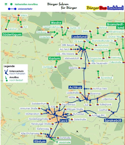
- ↑ BürgerBus Ladelund eV - Citizens drive for citizens. Retrieved March 3, 2019 .
- ↑ BürgerBus Ladelund eV - route network. Retrieved March 3, 2019 .
Achtrup | Ahrenshöft | Ahrenviöl | Ahrenviölfeld | Alkersum | Almdorf | Arlewatt | Aventoft | Bargum | Behrendorf | Bohmstedt | Bondelum | Bordelum | Borgsum | Bosbull | Braderup | Bramstedtlund | Bredstedt | Breklum | Dagebüll | Drage | Drelsdorf | Dunsum | Elisabeth-Sophien-Koog | Ellhöft | Emmelsbüll-Horsbüll | Narrow Sands | Fresendelf | Friedrich-Wilhelm-Lübke-Koog | Friedrichstadt | Galmsbüll | Garding | Garding, parish | Goldebek | Goldelund | Gröde | Grothusenkoog | Haselund | Hattstedt | Hattstedtermarsch | Högel | Spar | Hooge | Hörnum (Sylt) | Horstedt | Hude | Humptrup | Husum | Immenstedt | Joldelund | Kampen (Sylt) | Karlum | Katharinenheerd | Klanxbüll | Klixbull | Koldenbüttel | Kolkerheide | Kotzenbüll | Ladelund | Langeneß | Langenhorn | Leak | Lexgaard | List on Sylt | Löwenstedt | Lütjenholm | Midlum | Mildstedt | Fog | Neukirchen | Nieblum | Niebüll | Norddorf on Amrum | Norderfriedrichskoog | North beach | Norstedt | Ockholm | Oevenum | Oldenswort | Oldersbek | Olderup | Oldsum | Ostenfeld (Husum) | Oster-Ohrstedt | Osterhever | Pellworm | Poppenbüll | Ramstedt | Rantrum | Reußenköge | Risum-Lindholm | Rodenäs | Sankt Peter-Ording | Schwabstedt | Schwesing | Seeth | Simonsberg | Sollwitt | Sönnebüll | Sprakebull | Stadum | Stedesand | Struckum | South end | Süderhöft | Süderlügum | South March | Sylt | Tating | Tetenbull | Tinningstedt | Tönning | Tümlauer-Koog | Uelvesbüll | Uphusum | Utersum | Viöl | Vollerwiek | Vollstedt | World | Wenningstedt-Braderup (Sylt) | Wester-Ohrstedt | Westerhever | Westre | Winnert | Wipe | Witsum | Wittbek | Wittdün on Amrum | Joke word | Wobbenbüll | Wrixum | Wyk on Föhr