Gerde (Hautes-Pyrénées)
|
Gerde Gerda |
||
|---|---|---|

|
|
|
| region | Occitania | |
| Department | Hautes-Pyrénées | |
| Arrondissement | Bagneres-de-Bigorre | |
| Canton | La Haute-Bigorre | |
| Community association | Haute-Bigorre | |
| Coordinates | 43 ° 3 ' N , 0 ° 10' E | |
| height | 550-1,033 m | |
| surface | 6.93 km 2 | |
| Residents | 1,136 (January 1, 2017) | |
| Population density | 164 inhabitants / km 2 | |
| Post Code | 65200 | |
| INSEE code | 65198 | |
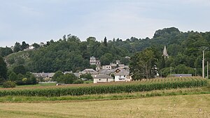
 Look at Gerde |
||
Gerde is a French commune in the department of Hautes-Pyrénées in the region Occitania . It belongs to the arrondissement of Bagnères-de-Bigorre and the canton of La Haute-Bigorre (until 2015: canton of Campan ). It has 1,136 inhabitants (as of January 1, 2017), who are called Gerdois .
geography
Gerde is located in the historic Bigorre region on the Adour River . Gerde is surrounded by the neighboring communities of Bagnères-de-Bigorre in the north and west, Uzer in the north and northeast, Lies in the east and Asté in the south.
Population development
| year | 1962 | 1968 | 1975 | 1982 | 1990 | 1999 | 2006 | 2013 |
|---|---|---|---|---|---|---|---|---|
| Residents | 881 | 1001 | 1040 | 1145 | 1191 | 1116 | 1140 | 1194 |
| Source: Cassini and INSEE | ||||||||
Attractions
- Saint-Julien church
Web links
Commons : Gerde - collection of images, videos and audio files
