
Sarrancolin
| Sarrancolin | ||
|---|---|---|

|
|
|
| region | Occitania | |
| Department | Hautes-Pyrénées | |
| Arrondissement | Bagneres-de-Bigorre | |
| Canton | Neste, Aure and Louron | |
| Community association | Communauté de communes Aure Louron | |
| Coordinates | 42 ° 58 ' N , 0 ° 23' E | |
| height | 600-1,890 m | |
| surface | 32.1 km 2 | |
| Residents | 563 (January 1, 2017) | |
| Population density | 18 inhabitants / km 2 | |
| Post Code | 65410 | |
| INSEE code | 65408 | |
 Sarrancolin |
||

Sarrancolin is a French municipality with 563 inhabitants (as of January 1 2017) in the department of Hautes-Pyrénées in the region Occitania . It belongs to the arrondissement of Bagnères-de-Bigorre and the canton of Neste, Aure et Louron .
geography
The municipality is located in the Pyrenees . In Sarrancolin is from Neste derived water to deal with this by using the plateau of Lannemezan leading Canal de la Neste to feed other rivers and streams that lead to the summer a little water.
Neighboring municipalities are Hèches in the north, Nistos in the northeast, Ferrère in the east, Ardengost in the southeast, Beyrède-Jumet-Camous in the south and west and Ilhet in the southwest.
Population development
| year | 1962 | 1968 | 1975 | 1982 | 1990 | 1999 | 2008 | 2015 |
|---|---|---|---|---|---|---|---|---|
| Residents | 1013 | 1008 | 868 | 772 | 684 | 689 | 627 | 570 |

Notre-Dame-d'Esplantas chapel
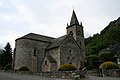
Saint-Pierre-Saint-Ebons church, monument historique since 1903
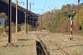
Site of the former station of Sarrancolin on the railway line from Lannemezan to Arreau -Cadéac

Mairie Sarrancolin

Fallen memorial
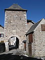
Former prison tower

Sarrancolin Schoolhouse


.jpg)
.jpg)