
Tuzaguet
|
Tuzaguet Tusaguèth |
||
|---|---|---|
.svg)
|
|
|
| region | Occitania | |
| Department | Hautes-Pyrénées | |
| Arrondissement | Bagneres-de-Bigorre | |
| Community association | Neste Barousse | |
| Coordinates | 43 ° 5 ' N , 0 ° 26' E | |
| height | 480-574 m | |
| surface | 7.72 km 2 | |
| Residents | 453 (January 1, 2017) | |
| Population density | 59 inhabitants / km 2 | |
| Post Code | 65150 | |
| INSEE code | 65455 | |
_1.jpg) Mairie Tuzaguet |
||

Tuzaguet ( Occitan : Tusaguèth ) is a French commune with 453 inhabitants (as of January 1, 2017) in the Hautes-Pyrénées department in the Occitania region ; it belongs to the arrondissement of Bagnères-de-Bigorre and to the community association Neste Barousse, founded in 2016 . The inhabitants are called Tuzaguetois / Tuzaguetoises .
geography
Tuzaguet is located around 34 kilometers southeast of the city of Tarbes in the east of the Hautes-Pyrénées department. The community consists of the village of Tuzaguet and numerous scattered settlements. Tuzaguet is located between the Neste and the Lannemezan Plateau , about seven kilometers southeast of Lannemezan .
Tuzaguet is surrounded by the neighboring communities of Cantaous in the north, Anères in the east, Bizous in the south, Montoussé in the southwest and Escala in the west.
history
A place Tusagued appears for the first time indirectly with a man Guillelmus Garsia de Tusagued around the year 1140/1141 in the documents of Bonnefont. In the Middle Ages, the place was within the Nébouzan region, which in turn was part of the Gascogne province. The parish belonged to the district La Barthe from 1793 to 1801. In addition, Tuzaguet was within the canton of Saint-Laurent-de-Neste from 1793 to 2015 . The municipality has been part of the Bagnères-de-Bigorre arrondissement since 1801. In 1957, part of the previous parish split off and became the parish of Cantaous .
Population development
| year | 1962 | 1968 | 1975 | 1982 | 1990 | 1999 | 2006 | 2017 | |
| Residents | 460 | 471 | 426 | 444 | 433 | 408 | 448 | 453 | |
| Sources: Cassini and INSEE | |||||||||
Attractions
- Notre-Dame-de-l'Assomption ( Assumption ) Church
- Saint Roch chapel
- Lavoir (wash house)
- Village fountain
- Memorial to the Fallen
- numerous wayside crosses
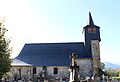
Notre-Dame de l'Assomption (Assumption) church

Saint Roch chapel

Memorial to the Fallen
_1.jpg)
_1.jpg)
_1.jpg)
Economy and Infrastructure
19 farms are located in the municipality (grain cultivation, dairy farming, breeding of horses, cattle, sheep and goats).
The D 938 trunk road from Capvern to Montréjeau runs through the municipality of Tuzaguat . In the nearby town of Lannemezan there is a connection to the Autoroute A 64 from Bayonne to Toulouse . Lannemezan station, seven kilometers from Tuzaguet, is on the Toulouse – Bayonne railway line .