Hauban
| Hauban | ||
|---|---|---|

|
|
|
| region | Occitania | |
| Department | Hautes-Pyrénées | |
| Arrondissement | Bagneres-de-Bigorre | |
| Canton | La Vallée de l'Arros et des Baïses | |
| Community association | Haute-Bigorre | |
| Coordinates | 43 ° 6 ′ N , 0 ° 10 ′ E | |
| height | 459-621 m | |
| surface | 2.14 km 2 | |
| Residents | 111 (January 1, 2017) | |
| Population density | 52 inhabitants / km 2 | |
| Post Code | 65200 | |
| INSEE code | 65216 | |
 Mairie Hauban |
||
Hauban is a French commune with 111 inhabitants (as of January 1, 2017) in the Hautes-Pyrénées department in the Occitanie region (until 2015 Midi-Pyrénées ). The municipality belongs to the Arrondissement of Bagnères-de-Bigorre and to the Haute-Bigorre municipal association founded in 1994 .
geography
The municipality of Hauban is located in the Bigorre landscape in the foothills of the Pyrenees , about 20 kilometers southeast of the capital of the department, Tarbes and 20 kilometers east of Lourdes . The municipal area of 2.14 km² is bounded in the west by the upper reaches of the Arrêt-Darré river . The village of Hauban is located on a ridge between the valleys of Arrêt-Darré and the Ruisseau de Hauban , a tributary of the Arrêt . At 621 m above sea level, the highest point is reached on the southern border of the municipality. The hamlet of Pey belongs to Hauban. Hauban is surrounded by the neighboring communities of Orignac in the north, Mérilheu in the east, Bagnères-de-Bigorre in the south, Pouzac in the southwest and Ordizan in the northwest.
Place name
The place name first appeared in 1429 as Auben . From 1740 onwards, the spelling Hauban, which is still used today, is found . When the church was founded from 1793 to 1801, the place was called Laubau for a short time .
Population development
| year | 1962 | 1968 | 1975 | 1982 | 1990 | 1999 | 2006 | 2016 | |
| Residents | 76 | 76 | 64 | 90 | 106 | 97 | 84 | 109 | |
| Sources: Cassini and INSEE | |||||||||
coat of arms
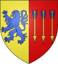
Blazon : "Split, in front in gold a blue upright lion walking to the right , behind in red three downward golden arrows with blue fletching."
Attractions
- Sainte-Bernadette Church
Economy and Infrastructure
Hauban has a rural character. 14 farms are located in the municipality (grain cultivation, sheep, goat and cattle breeding, dairy farming).
Due to its close proximity to the arrondissement capital Bagnères-de-Bigorre , the municipality of Hauban has good transport links. In Tournay , 15 kilometers away, there is a connection to the A 64 autoroute . Tournay is also the closest train station - on the Toulouse – Bayonne railway line .
supporting documents
- ↑ Michel Grosclaude and Jean-François: le Dictionnaire toponymique des communes des Hautes Pyrénées
- ↑ Hauban on cassini.ehess.fr (French)
- ↑ Hauban on cassini.ehess.fr
- ↑ Hauban on insee.fr
- ↑ Farms on annuaire-mairie.fr (French)


