
Salechan
|
Saléchan Seleishan |
||
|---|---|---|
.svg)
|
|
|
| region | Occitania | |
| Department | Hautes-Pyrénées | |
| Arrondissement | Bagneres-de-Bigorre | |
| Canton | La Vallée de la Barousse | |
| Community association | Neste Barousse | |
| Coordinates | 42 ° 57 ' N , 0 ° 38' E | |
| height | 459-1,495 m | |
| surface | 4.10 km 2 | |
| Residents | 272 (January 1, 2017) | |
| Population density | 66 inhabitants / km 2 | |
| Post Code | 65370 | |
| INSEE code | 65398 | |
 Saint-Julien Chapel |
||

Saléchan ( Gaskognisch Seleishan ) is a French commune with 272 inhabitants (as of January 1, 2017) in the Hautes-Pyrénées department in the Occitanie region ; it belongs to the Arrondissement of Bagnères-de-Bigorre and the municipality of Neste Barousse .
geography
Saléchan is the easternmost commune in the Hautes-Pyrénées department. It is located around 54 kilometers southeast of the city of Tarbes in the east of the Hautes-Pyrénées department on the border with the Haute-Garonne department. The community consists of the village of Saléchan, numerous houses along the D825 and a few individual farms. Large parts of the mountain slopes are forested. The Garonne crosses the municipality and in parts forms the eastern municipal boundary. The Canal du Moulin in the municipality of Saléchan is an artificial branch of the Garonne. The highest point in the municipality is the Sommet de Cot de Coudous . In terms of traffic, the community is located on the D825 west of the N125 .
history
Remains from Gallo-Roman times have been found near the church and the former rectory. The place is mentioned as Salisa / Salissa for the first time in the year 1180/1190 in the copy book of Lézat. In the Middle Ages, the place was within the county of Barousse in the Armagnac region , which in turn was part of the Gascogne province. The parish belonged to the district La Barthe from 1793 to 1801. In addition, Saléchan was within the canton of Mauléon-Barousse from 1793 to 2015 . The municipality has been part of the Bagnères-de-Bigorre arrondissement since 1801.
Population development
| year | 1793 | 1851 | 1872 | 1906 | 1921 | 1936 | 1946 | 1962 | 1968 | 1975 | 1982 | 1990 | 1999 | 2006 | 2014 |
| Residents | 481 | 803 | 627 | 680 | 464 | 469 | 294 | 286 | 266 | 245 | 246 | 204 | 174 | 220 | 238 |
| Sources: Cassini and INSEE | |||||||||||||||
Attractions
- Saint-Julien-de-Brioude village church
- Saint-Julien chapel with reliefs from the Gallo-Roman period, a historic monument since 1979
- Memorial to the Fallen
- two wayside crosses
- Lavoir (wash house)
- Écomusée Ferme les jours heureux
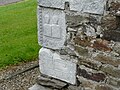
Reliefs from the Gallo-Roman period

Memorial to the Fallen

The Garonne on the municipal boundary
.jpg)

