
Lançon (Hautes-Pyrénées)
| Lançon | ||
|---|---|---|
.svg)
|
|
|
| region | Occitania | |
| Department | Hautes-Pyrénées | |
| Arrondissement | Bagneres-de-Bigorre | |
| Canton | Neste, Aure and Louron | |
| Community association | Aure Louron | |
| Coordinates | 42 ° 53 ' N , 0 ° 22' E | |
| height | 918-1,365 m | |
| surface | 2.80 km 2 | |
| Residents | 32 (January 1, 2017) | |
| Population density | 11 inhabitants / km 2 | |
| Post Code | 65240 | |
| INSEE code | 65255 | |
_2.jpg) View of the center of Lançon |
||

Lançon is a French commune with 32 inhabitants (as of January 1, 2017) in the Hautes-Pyrénées department in the Occitanie region (before 2016: Midi-Pyrénées ). The municipality belongs to the arrondissement of Bagnères-de-Bigorre and the canton of Neste, Aure et Louron (until 2015: canton of Arreau ).
The inhabitants are called Lançonnais and Lançonnaises .
geography
Lançon is located about 27 kilometers southeast of Bagnères-de-Bigorre in the historic province of Quatre-Vallées .
Lançon is surrounded by the six neighboring municipalities:
| Cadéac | Arreau | |
| Grézian |
.svg)
|
Cazaux Debat |
| Gouaux | Bordères-Louron |
The highest point of the municipality is on the summit of Peyre Blanque in the south of the municipality ( 1365 m ).
Lançon is located in the catchment area of the Garonne River . The Ruisseau de Bacarisse, also called Ruisseau de Garenne, rises in the area of the municipality and flows into the Neste in the western neighboring municipality of Grézian .
_1.jpg)
_1.jpg)
Toponymy
The Occitan name of the municipality is Lançon.
It has its origins in a country estate in antiquity . It is derived from the Latin proper name Lancius or Lantius with the suffix -onem ("Landgut des Lancius" or "Landgut des Lantius").
Toponyms and mentions of Lançon were:
- De Lampsono (1387, Church Register des Comminges ),
- Lanson (1767, Larcher, Kopialbuch des Comminges),
- Lanson , (1750 and 1790, map by Cassini or Département 1),
- Lançon (1793, Notice Communale ),
- Laucon (1801, Bulletin des lois ).
Population development
After records began, the population rose to a peak of around 105 by the first half of the 19th century. In the period that followed, the size of the community fell to around 20 inhabitants during short recovery phases by the 1960s, before a phase with moderate growth began which for the most part is still going on.
| year | 1962 | 1968 | 1975 | 1982 | 1990 | 1999 | 2006 | 2011 | 2017 |
|---|---|---|---|---|---|---|---|---|---|
| Residents | 20th | 18th | 19th | 27 | 31 | 30th | 28 | 36 | 32 |

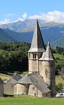
Parish Church of Sainte-Eulalie
The church, consecrated to St. Eulalia of Mérida , has preserved Romanesque elements from the 12th century, the semicircular choir with a cauldron vault , the transept with a barrel vault and the columns of the main nave. The vault of the main nave and the entrance portal , however, are built in the Gothic style. The main nave, the bell tower and the northern side chapel were built in 1533, as evidenced by the corresponding year on one of the pillars between the chapel and the main nave. The south side chapel was added in the 19th century. The side chapels and the ground floor of the vestibule under the bell tower are provided with a ribbed vault , with the keystones in the vestibule decorated with lilies and the capitals with human heads. The polygonal bell tower with a polygonal helmet is flanked by a round stair tower. The church has been inscribed as a Monument historique since July 20, 1979 .
Parish Church of Sainte-Eulalie

apse
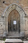
Entrance portal
_1.jpg)


Economy and Infrastructure

Lançon is located in the AOC zones of the Porc noir de Bigorre pig breed and the Jambon noir de Bigorre ham .

Total = 3
traffic
Lançon can be reached via Routes départementales 25 and 219.
Web links
Individual evidence
- ↑ Information commune de Lançon ( fr ) Marie-Pierre Manet. Retrieved November 21, 2019.
- ↑ Ma commune: Lançon ( fr ) Système d'Information sur l'Eau du Bassin Adour Garonne. Retrieved November 21, 2019.
- ↑ Lançon ( fr ) Hautes-Pyrénées department. Retrieved November 21, 2019.
- ^ David Rumsey Historical Map Collection France 1750 ( en ) David Rumsey Map Collection: Cartography Associates. Retrieved November 21, 2019.
- ↑ a b Notice Communale Lançon ( fr ) EHESS . Retrieved November 21, 2019.
- ↑ Populations légales 2016 Commune de Lançon (65255) ( fr ) INSEE . Retrieved November 21, 2019.
- ^ Pierre-Yves Corbel: Église paroissiale Sainte-Eulalie ( fr ) French Ministry of Culture . December 30, 2018. Retrieved November 21, 2019.
- ^ Église Sainte-Eulalie ( fr ) French Ministry of Culture . November 5, 2019. Retrieved November 21, 2019.
- ↑ Institut national de l'origine et de la qualité: Rechercher un produit ( fr ) Institut national de l'origine et de la qualité . Retrieved November 21, 2019.
- ↑ Caractéristiques des établissements en 2015 Commune de Lançon (65255) ( fr ) INSEE . Retrieved November 21, 2019.