
Nestier
|
Nestier Nestièr |
||
|---|---|---|
.svg)
|
|
|
| region | Occitania | |
| Department | Hautes-Pyrénées | |
| Arrondissement | Bagneres-de-Bigorre | |
| Canton | La Vallée de la Barousse | |
| Community association | Neste Barousse | |
| Coordinates | 43 ° 4 ′ N , 0 ° 29 ′ E | |
| height | 458-604 m | |
| surface | 4.94 km 2 | |
| Residents | 156 (January 1, 2017) | |
| Population density | 32 inhabitants / km 2 | |
| Post Code | 65150 | |
| INSEE code | 65327 | |
.jpg) Mairie Nestier |
||

Nestier ( Occitan : Nestièr ) is a French commune with 156 inhabitants (as of January 1, 2017) in the Hautes-Pyrénées department in the Occitania region ; it belongs to the arrondissement of Bagnères-de-Bigorre and to the community association Neste Barousse, founded in 2016 . The inhabitants are called Nestéens .
geography

Nestier is located in the foothills of the Pyrenees, which extends furthest to the north, between the Comminges and Lannemezan plateau , eleven kilometers southwest of Lannemezan and around 24 kilometers west of the city of Saint-Gaudens . In the north, the 4.94 km² large municipal area extends to the right bank of the Neste River . The village of Nestier came into being at the point where the river Pontic entered the Neste plain. The pontic, however, was diverted further to the northeast to bypass a quarry and only flows over the Merdan into the Neste in the municipality of Aventignan . In addition to the main settlement Nestier ( 500 m ), the districts of Cap de la Bielle ( 510 m ) and Capont ( 515 m ) belong to the municipality . The village of Nestier is framed by two wooded mountain tops: Mont Arès ( 604 m ) in the southwest and Monsaoux ( 564 m ) in the south. In the community there are meadows, fields and trees in constant change, in the southeast and around the mountain tops mentioned there are somewhat larger forest areas.
Nestier is surrounded by the neighboring communities of Anères and Saint-Laurent-de-Neste in the north, Montégut in the east, Bize in the south and Hautaget in the west.
Toponymy
Nestier (who lives at the nest ) is probably a pre-Latin place name that goes back to the pre-Indo-European hydronym nesta (= river). Its origin would therefore be Aquitaine or Basque-Aquitaine.
The name of the district of Cap de la Bielle came from the Gaskognischen and means translated around the end of the settlement .
The highest point in the municipality, the 604 m high Mont Arès, could go back to the Greek god of war Ares . However, this thesis is controversial among linguists; proponents argue that the origin of the word Pyrenees could be found in the Greek name Pyrene .
history
In the period of the Middle Paleolithic (about 50,000 years ago) nomadic Neanderthals lived in the area around Nestier, which was proven by the investigations in the 1960s in the cave of Cap de la Bielle, although parts of the cave were destroyed until the 1950s because plaster was mined here . The cave is one of the few in France with a neat stratigraphic sequence. Here, for example, the presence of the reindeer has been proven and numerous artifacts have been found, including crushing tools and a flat core disk.
In 1872, five bronze age dolmens were identified in Nestier and the surrounding area . In addition, a bronze ax was found and a villager discovered the remains of a Gallic cemetery. There were also two tumuli on the Neste between Nestier and Saint-Laurent-de-Neste . It is believed by some local researchers that an early pre-Roman oppidum was located near Nestier . They rely on Quitanian-Roman remains of a castle hill and a primitive fortress. Finally, there are stones from an Aquitaine-Roman votive altar in the wall of the park by the church.
In the 13th century, the lands around Nestier belonged to the province of Guyenne , located on the border of Bigorre and Comminges , the diocese of Comminges and until 1398 belonged to the rule of La Barthe-de-Neste . Nestier suffered badly from a plague epidemic and from armed conflicts, such as the Hundred Years War, the war between Counties Foix and Armagnac , the war between Comminges and Bigorre, several looting of marauding mercenaries and famine.
In the period before the French Revolution, the traditions of carpenters and weavers were established. Handmade furniture from Nestier is still in demand today; weaving based on flax, which was then grown around Nestier, has ceased.
In the 19th century, Nestier also made candles with thick, braided wicks dipped in locally sourced nut oil. They were then attached to wrought-iron candlesticks in every house, ready for use.
At the end of the 19th century, the villagers, under the direction of the village priest, laid a way of the cross with several oratorios uphill to Mont Arès . However, this fell into disrepair in the 1920s.
In the First World War, 19 residents of the Nestier community died, whose names can be found on the monument aux morts that was erected in 1927 . By the 1930s, every home had running water and electricity; Washhouses and communal drinking troughs made life easier.
In the last quarter of the 20th century the population of the community declined: farms gradually disappeared, some houses were converted into second homes or holiday homes. Between 1980 and 1990 the oratorios on the way to Mont Arès were restored and at the beginning of the 21st century a large outdoor pool was built next to the sports field on the Neste level.
Stones from an Aquitaine-Roman votive altar on the church park wall

Replica of the castle hill and a primitive fortress from Aquitaine-Roman times

North facade of the church at the time of the Restoration in 1901

Oratorios and chapel after the restoration
.jpg)


.jpg)
Population development
| year | 1962 | 1968 | 1975 | 1982 | 1990 | 1999 | 2006 | 2016 |
| Residents | 186 | 228 | 289 | 180 | 196 | 165 | 171 | 159 |
| Sources: Cassini and INSEE | ||||||||
Attractions
- Town hall ( mairie ), built 1832–1834 with a classroom from the first boys' school from 1850, initially also as a court of justice, now also used for weddings and other celebrations; the barrier of the court of justice from 1850 is still preserved
- House of the former girls' school from 1850, later an outbuilding of the mother house of the Sisters of Saint Joseph of Tarbes in the Cantaous monastery ; after the closure in 1903 from 1924 to 1986 house of the elementary school
- Parish church of Saint-Jean-Baptiste from the late Middle Ages built in place of an earlier Aquitaine-Roman villa rustica ; with restorations in 1792 and 1901; a bell and three stained glass windows are from 1961; the church cemetery was abandoned at the end of the 19th century
- Memorial for the dead of the Franco-German conflict, the First and Second World Wars and the Indochina War
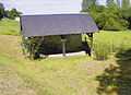
- Calvary of Mont-Arès, path on the 604 m high mountain Mont-Arès with several oratories and the Chapel of the Cross ( Chapelle haute du chemin de croix ), built between 1860 and 1870, Monument historique
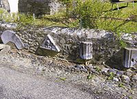
- two wash houses ( lavoirs ) and cattle troughs

Barrier of the Friedensgericht in the town hall hall

Parish church and old cemetery at the beginning of the 20th century
Lavoir and cattle trough La Hounte
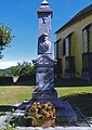
Fallen memorial

Saint-Jean-Baptiste church

Way of the Cross Chapel ( Chapelle haute du chemin de croix )
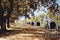
Oratorios on the Calvaire du Mont-Arès

outdoor pool
.jpg)


_1.jpg)
_1.jpg)
_du_Calvaire_du_Mont-Ar%C3%A8s.jpg)

Economy and Infrastructure
Nestier is an agricultural community with six farmers who mainly breed cattle (horses, dairy cows, sheep, goats).
From Nestier there are road links to Anères , Saint-Laurent-de-Neste , Montégut , Bize and Hautaget . In Lannemezan , eleven kilometers away, there is a connection to the A 64 autoroute . Lannemezan station is on the Toulouse – Bayonne railway line .
supporting documents
- ^ Dictionnaire des noms de lieux des Hautes-Pyrénées (DNLHP) and Toponymie Générale de la France (TGF) by MR Aymard and M. l'abbé Nègre, 1931.
- ↑ Essai d'explication de micro-toponymie by D. Henry in the Revue de Comminges , 1995, p. 390.
- ↑ Le Panthéon pyrénéen by M. Marliave and Pertuzé, 1990.
- ↑ Pays des Nestes et de Comminges, des origines à nos jours by J. Brau, 2014.
- ^ Circonscription de Toulouse, Hautes-Pyrénées: Nestier, Campan, Montoussé, Sombrun by M. Méroc, Sources: Gallia Préhistoire , Volume 6, pp. 208-216, Paris 1963; L'industrie lithique de la grotte du Cap de la Bielle à Nestier and Bulletin de la Société méridionale de spéléologie et de préhistoire , Volume 10, pp. 12-13, Toulouse 1964 and Circonscription de Toulouse, Hautes-Pyrénées: Nestier and Gallia Préhistoire , Volume 10, p. 411, Paris 1967.
- ↑ Études historiques sur le pays des Quatre-Vallées by M. Barifouse, 1874.
- ^ Dictionnaire toponymique des communes des Hautes-Pyrénées by M. Grosclaude and JF Le Nail, 2000.
- ↑ Société Académique des Hautes - Pyrénées: Fête académique de Nestier - Résurrections archéologiques - Promenades archéologiques of May 1899, Bulletin local , 2e série, 31e fascicule, pp. 42, 43, 48.
- ↑ Collectories de 1369 from Revue de Comminges, 2001/03 , Volume 117, pp. 346, 351, 371 in the National Library of France
- ^ Monograph villageoise by M. Barrère, 1887.
- ^ Monograph de Nestier; cahier destiné à l'école de Nestier , 1942–1949, first part: histoire locale of Madame Bize and archives communales
- ↑ Monastère sur le Mont-Arès , 1860, Communauté des Olivétains de Saint-Bertrand-de-Comminges in the Mabillon Revue: archives de la France monastique , 1905, p. 203.
- ^ Monograph de Nestier; cahier destiné à l'école de Nestier , 1942–1949, first part: histoire locale of Madame Bize and archives communales
- ↑ Nestier outdoor pool (French)
- ↑ Nestier on cassini.ehess.fr (French)
- ↑ Nestier on insee.fr
- ^ Entry in the Base Mérimée of the Ministry of Culture. Retrieved October 23, 2019 (French).
- ↑ Farms on annuaire-mairie.fr (French)