
Cadéac
| Cadéac | ||
|---|---|---|
.svg)
|
|
|
| region | Occitania | |
| Department | Hautes-Pyrénées | |
| Arrondissement | Bagneres-de-Bigorre | |
| Canton | Neste, Aure and Louron | |
| Community association | Aure Louron | |
| Coordinates | 42 ° 53 ' N , 0 ° 21' E | |
| height | 716-1,607 m | |
| surface | 6.15 km 2 | |
| Residents | 305 (January 1, 2017) | |
| Population density | 50 inhabitants / km 2 | |
| Post Code | 65240 | |
| INSEE code | 65116 | |
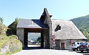
_1.jpg) View of the center of Cadéac |
||

Cadéac is a French commune with 305 inhabitants (as of January 1, 2017) in the Hautes-Pyrénées department in the Occitanie region (before 2016: Midi-Pyrénées ). The municipality belongs to the arrondissement of Bagnères-de-Bigorre and the canton of Neste, Aure et Louron (until 2015: canton of Arreau ).
The inhabitants are called Caducéens and Caducéennes .
geography
Cadéac is located about 26 kilometers southeast of Bagnères-de-Bigorre in the historic province of Quatre-Vallées .
Cadéac is surrounded by the five neighboring municipalities:
| Barrancoueu | Arreau | |
| Arreau |
.svg)
|
Lançon |
| Ancizan | Grézian |
Population development
After records began, the population rose to a peak of around 520 by the middle of the 19th century. In the following period, the size of the community fell to around 135 inhabitants with short recovery phases until the 1980s, before a phase of growth began that is still today persists.
| year | 1962 | 1968 | 1975 | 1982 | 1990 | 1999 | 2006 | 2011 | 2017 |
|---|---|---|---|---|---|---|---|---|---|
| Residents | 223 | 181 | 169 | 134 | 161 | 221 | 236 | 263 | 305 |

Attractions
- Parish church of Saint-Félix with origins from the 12th century
- Notre-Dame de Pène-Tailhade chapel from the second half of the 16th century, registered as a Monument historique since July 22, 1971
- Cadéac castle ruins from the 13th century
- Wayside shrine Sainte-Luce from the 19th century
- Former thermal baths from the 19th century

Saint-Félix parish church
Notre-Dame de Pène-Tailhade chapel
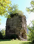
Cadéac castle ruins
_5.jpg)
_1.jpg)
_1.jpg)
Economy and Infrastructure

Cadéac is in the AOC zone of the Porc noir de Bigorre pig breed .

total = 40
sport and freetime
The long-distance hiking trail GR 105 from Lortet to Port d'Ourdissétou also leads through the center of Cadéac. It is an alternative route to a parallel route to the Via Tolosana , one of the four Camino de Santiago in France.
traffic
_-_LiO_(Figeac_*_ao%C3%BBt_2018).jpg)
Cadéac can be reached via Routes départementales 19, 113, 219, 919 and 929, the former Route nationale 129 .
The commune is also connected to other communes in the department by a line from the Lignes intermodales d'Occitanie bus network from Lannemezan to Saint-Lary-Soulan .
Web links
- Website of the Working Group of Noir de Bigorre (French)
- Website of the Lignes intermodales d'Occitanie (LIO) bus network (French)
Individual evidence
- ^ Informations sur la commune de Cadéac ( fr ) Marie-Pierre Manet. Retrieved November 5, 2019.
- ↑ Notice Communale Cadéac ( fr ) EHESS . Retrieved November 5, 2019.
- ↑ Populations légales 2016 Commune de Cadéac (65116) ( fr ) INSEE . Retrieved November 5, 2019.
- ↑ Institut national de l'origine et de la qualité: Rechercher un produit ( fr ) Institut national de l'origine et de la qualité . Retrieved November 5, 2019.
- ↑ Caractéristiques des établissements en 2015 Commune de Cadéac (65116) ( fr ) INSEE . Retrieved November 5, 2019.
- ↑ La voie des Piémonts ( fr ) Agence de Coopération Interrégionale et Réseau “Chemins de Saint-Jacques de Compostelle”. Retrieved November 5, 2019.
- ↑ De Lortet au port d'Ourdissetou ( fr ) Association des Amis de Saint Jacques des Hautes Pyrénées. Retrieved November 5, 2019.