
Aragnouet
|
Aragnouet Aranhoet |
||
|---|---|---|
.svg)
|
|
|
| region | Occitania | |
| Department | Hautes-Pyrénées | |
| Arrondissement | Bagneres-de-Bigorre | |
| Canton | Neste, Aure and Louron | |
| Community association | Aure Louron | |
| Coordinates | 42 ° 47 ' N , 0 ° 14' E | |
| height | 956-3,194 m | |
| surface | 108.29 km 2 | |
| Residents | 248 (January 1, 2017) | |
| Population density | 2 inhabitants / km 2 | |
| Post Code | 65170 | |
| INSEE code | 65017 | |
 View of Aragnouet |
||

Aragnouet ( Occitan : Aranhoet ) is a French commune with 248 inhabitants (as of January 1, 2017) in the Hautes-Pyrénées department in the Occitanie region (before 2016 Midi-Pyrénées ). It belongs to the arrondissement of Bagnères-de-Bigorre and the canton of Neste, Aure et Louron (until 2015 vielle-Aure ).
geography
Aragnouet is about 25 kilometers south of Bagnères-de-Bigorre am Neste . In the south of the municipality, the border with Spain runs along the main Pyrenees ridge . Aragnouet is surrounded by the neighboring communities of Saint-Lary-Soulan and Vignec in the north and north-east, Cadeilhan-Trachère in the north-east, Tramezaïgues in the east, Bielsa (Spain) in the south, Gavernie-Gèdre with Gèdre in the west, Luz-Saint-Sauveur in the west and north-west and Barèges in the north-west.
Population development
| year | 1962 | 1968 | 1975 | 1982 | 1990 | 1999 | 2006 | 2013 |
| Residents | 215 | 201 | 160 | 260 | 336 | 260 | 246 | 242 |
Attractions
- Saint-Pierre-aux-Liens church in Aragnouet
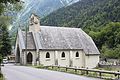
- Saint-Pierre-aux-Liens church in Éget
- Saint-Pierre-aux-Liens church in Fabian
- several chapels
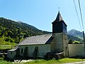
Saint-Pierre-aux-Liens church in Aragnouet

Saint-Pierre-aux-Liens church in Éget
Saint-Pierre-aux-Liens church in Fabian
.JPG)
_3.jpg)
