Cieutat
| Cieutat | ||
|---|---|---|

|
|
|
| region | Occitania | |
| Department | Hautes-Pyrénées | |
| Arrondissement | Bagneres-de-Bigorre | |
| Canton | La Vallée de l'Arros et des Baïses | |
| Community association | Communes de la Haute-Bigorre | |
| Coordinates | 43 ° 7 ' N , 0 ° 13' E | |
| height | 327-589 m | |
| surface | 18.78 km 2 | |
| Residents | 600 (January 1, 2017) | |
| Population density | 32 inhabitants / km 2 | |
| Post Code | 65200 | |
| INSEE code | 65147 | |
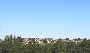
 View of the center of Cieutat |
||
Cieutat is a French commune with 600 inhabitants (as of January 1, 2017) in the Hautes-Pyrénées department in the Occitanie region (before 2016: Midi-Pyrénées ). The municipality belongs to the arrondissement of Bagnères-de-Bigorre and the canton of La Vallée de l'Arros et des Baïses (until 2015: canton of Bagnères-de-Bigorre ).
The inhabitants are called Cieutatois and Cieutatois .
geography
Cieutat is located about eight kilometers northeast of Bagnères-de-Bigorre in the historic vice-county of Nébouzan .
Cieutat is surrounded by the ten neighboring communities:
| Luc | Poumarous |
Ozone Chelle-Spou |
| Orignac |

|
Artiguemy |
|
Mérilheu Argelès-Bagnères |
Castillon | Bonnemazon |
Cieutat lies in the catchment area of the Adour River .
Tributaries of the Arros cross the territory of the municipality:
- the Luz ,
- the Arriou-Darré, which rises in Cieutat,
- the Ruisseau Gascorre, which rises in Cieutat,
- the Arrédou which rises in Cieutat and
- the arrêt .

Toponymy
The Occitan name of the community is Ciutat. It comes from the Latin civitatem , which denotes the area of a people or their capital. The place could once be the main place of the Onobrisaten (origin of the name Nébouzan), an Aquitanian people, as Pliny the Elder referred to them in his work Naturalis historia , or a fortified camp of the Franks who marched against the rebellious Gascon . However, the origin of the name Neurest / Nauares / Navares / Nauarest , which existed before, is unclear .
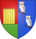
A nickname of the residents of the community is Eths gavecats ( German the little owls ) because they have piercing voices like owls. Another is Eths borra-pasta ( German for those who greedily eat pasta ), another is Eths porrotèrs ( German for turkey farmers ).
Toponyms and mentions of Cieutat were:
- Neurest (around 1110 and 12th century, copial book of the County of Bigorre),
- La Ciutat (around 1200–1230, Copial Book of the County of Bigorre),
- la Ciutad (1251, Du Bourg),
- villam Civitatis de Navares (1256, marriage contract Esquivat),
- ville Civitatis de Naverest (1257, Bigorre County Copies ),
- Ciutad (1285, census of the nobility in Bigorre),
- Laciotat (1300, elevation in Bigorre),
- De Civitate (1342 and 1379, parish registers of Tarbes and Procuration of Tarbes),
- La Ciutat (1429, Bigorre County Tax List),
- Cieutat (1614 and 1750, Guillaume Mauran or map by Cassini ),
- Cuitat (1793, Notice Communale ),
- Cieutat (1801, Bulletin des lois ).
Population development
After records began, the population rose to a peak of 1,410 by the middle of the 19th century. In the period that followed, the number of inhabitants fell to 470 with short recovery phases by the 1970s, before a growth phase began that continues to this day.
| year | 1962 | 1968 | 1975 | 1982 | 1990 | 1999 | 2006 | 2011 | 2017 |
|---|---|---|---|---|---|---|---|---|---|
| Residents | 521 | 470 | 457 | 509 | 539 | 518 | 557 | 599 | 600 |
Attractions
Notre-Dame de Roumé chapel
The 16th century chapel , according to local tradition, has an earlier origin and its name is reminiscent of an earlier establishment or a Roman temple at this location. It may have been destroyed during the Huguenot Wars and was largely restored in the 17th century. The building with a trapezoidal floor plan was erected on an artificial hill and is surrounded by a wall made of dry stone . The former apse was demolished at the beginning of the 19th century and replaced by the current three-walled apse. The masonry of the chapel is made of both ashlar and rubble stone, as well as pebbles that reveal changes over the centuries that are difficult to interpret. On the north and west sides of today's entrance, a monogram of Christ is set in the masonry above what could have been an earlier entrance with a keel arch . The west facade is determined by the bell gable . Inside, the building is covered by a false vault made of painted wooden beams. The floor is covered with old terracotta tiles . The altar is embellished by an altar retable in the style of the 18th century. A gallery with tiered rows of seats is built on the western wall . The chapel has been inscribed as a Monument historique since September 6, 1956 .
Saint-Barthélémy parish church
It is dedicated to the Apostle Bartholomew , the patron saint of the community. A statue depicting the saint with a knife in his right hand as a symbol of his skinning, according to legend, is made of painted wood and dates from the 16th century. It has been classified as a Monument historique since July 30, 1907 .
Economy and Infrastructure
Cieutat is located in the AOC zones of the Porc noir de Bigorre pig breed and the Jambon noir de Bigorre ham .

total = 59
education
The community has a public preschool and elementary school with 54 students in the 2019/2020 school year.
traffic
Cieutat can be reached via Routes départementales 20, 83, 120 and 938, the former Route nationale 638 .
Web links
Individual evidence
- ^ Informations sur la commune de Cieutat ( fr ) Marie-Pierre Manet. Retrieved November 9, 2019.
- ↑ Ma commune: Cieutat ( fr ) Système d'Information sur l'Eau du Bassin Adour Garonne. Retrieved November 9, 2019.
- ↑ Pliny the Elder: Liber IV - Geographia (Europe) ( Latin ) In: Naturalis historia . Pp. 1-10. AD 77. Retrieved November 9, 2019.
- ^ Cieutat ( fr ) Hautes-Pyrénées department. Retrieved November 9, 2019.
- ^ David Rumsey Historical Map Collection France 1750 ( en ) David Rumsey Map Collection: Cartography Associates. Retrieved November 9, 2019.
- ↑ a b Notice Communale Cieutat ( fr ) EHESS . Retrieved November 9, 2019.
- ↑ Populations légales 2016 Commune de Cieutat (65147) ( fr ) INSEE . Retrieved November 9, 2019.
- ↑ église paroissiale Saint-Michel ( fr ) French Ministry of Culture . October 13, 2015. Retrieved November 9, 2019.
- ↑ statue: saint Barthélémy ( fr ) French Ministry of Culture . February 20, 2001. Retrieved November 9, 2019.
- ↑ Institut national de l'origine et de la qualité: Rechercher un produit ( fr ) Institut national de l'origine et de la qualité . Retrieved November 9, 2019.
- ↑ Caractéristiques des établissements en 2015 Commune de Cieutat (65147) ( fr ) INSEE . Retrieved November 9, 2019.
- ^ École maternelle et élémentaire ( fr ) National Ministry of Education. Retrieved November 9, 2019.


