
Benqué-Molère
|
Benqué-Molère Benquèr-Molèra |
||
|---|---|---|
|
||
| region | Occitania | |
| Department | Hautes-Pyrénées | |
| Arrondissement | Bagneres-de-Bigorre | |
| Canton | La Vallée de l'Arros et des Baïses | |
| Community association | Plateau de Lannemezan | |
| Coordinates | 43 ° 6 ′ N , 0 ° 17 ′ E | |
| height | 329-611 m | |
| surface | 3.79 km 2 | |
| Residents | 126 (January 1, 2017) | |
| Population density | 33 inhabitants / km 2 | |
| Post Code | 65130 | |
| INSEE code | 65081 | |
_1.jpg) Town hall (Mairie) of Benqué-Molère |
||

Benqué-Molère ( Gascognisch Benquèr-Molèra ) is a French commune with 126 inhabitants (as of January 1, 2017) in the Hautes-Pyrénées department in the Occitanie region . It belongs to the Arrondissement of Bagnères-de-Bigorre and the canton of La Vallée de l'Arros et des Baïses . It was founded in 2017 from the municipalities of Benqué and Molère .
geography
Benqué-Molère is located about 21 kilometers southeast of Tarbes on the Lannemezan plateau . The Arros limits the community to the west. Benqué-Molère is surrounded by the neighboring communities of Mauvezin in the north, Capvern in the east and northeast, Tilhouse in the south and southeast, Sarlabous in the southwest, Bourg-de-Bigorre in the west and Bonnemazon in the northwest.
structure
| District | former INSEE code |
Area (km²) | Population (2013) |
|---|---|---|---|
| Benqué | 65081 | 2.05 | 83 |
| Molère | 65312 | 1.74 | 36 |
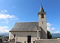
Attractions
- Saint-Etienne church of Benqué
- Church of Sainte-Barbe in Molère

Saint-Etienne church
Sainte-Barbe church
_1.jpg)
_1.jpg)