
Uzer (Hautes-Pyrénées)
|
Uzer Usèr |
||
|---|---|---|
.svg)
|
|
|
| region | Occitania | |
| Department | Hautes-Pyrénées | |
| Arrondissement | Bagneres-de-Bigorre | |
| Canton | La Vallée de l'Arros et des Baïses | |
| Community association | Haute-Bigorre | |
| Coordinates | 43 ° 5 ' N , 0 ° 12' E | |
| height | 437-722 m | |
| surface | 3.48 km 2 | |
| Residents | 105 (January 1, 2017) | |
| Population density | 30 inhabitants / km 2 | |
| Post Code | 65200 | |
| INSEE code | 65459 | |
_1.jpg) Mairie Uzer |
||

Uzer ( Occitan : Usèr ) is a French commune with 105 inhabitants (as of January 1, 2017) in the Hautes-Pyrénées department in the Occitania region (until 2015 Midi-Pyrénées ). The municipality belongs to the Arrondissement of Bagnères-de-Bigorre and to the Haute-Bigorre municipal association founded in 1994 . The inhabitants are called Uzérois .
geography
_1.jpg)
The municipality of Uzer is located in the Bigorre landscape on the northern edge of the Pyrenees , seven kilometers east of the arrondissement capital Bagnères-de-Bigorre and 20 kilometers southeast of Tarbes . The Luz , a tributary of the Gave de Pau in the Adour catchment area, flows through the 3.48 km² municipal area . The village of Uzer lies on a ridge at 571 meters above sea level, the hamlet of Bourdets , which belongs to the municipality, is on a neighboring mountain at an altitude of 610 m. Large parts of the community are forested, especially the valleys of the mountain streams and the steep slopes, while the high areas above about 500 m are characterized by pastures. Uzer is surrounded by the neighboring communities of Argelès-Bagnères in the north, Castillon in the northeast, Bettes in the east, Lies in the south, Gerde in the southwest and Bagnères-de-Bigorre in the west.
Place name
The oldest surviving place name is A User from the period between 1200 and 1230. The spelling developed into User, Usser and Huser (1429) via Uzier (1313) and the Latin de Userio (1342 and 1379 ). The names Uzer en Bigorre and Uzer en Nebouzan appeared in church registers from 1747 , before the name Uzer , which is still in use today, was established at the end of the 18th century (including on Cassini cards ) .
Population development
| year | 1962 | 1968 | 1975 | 1982 | 1990 | 1999 | 2006 | 2016 | |
| Residents | 95 | 74 | 74 | 71 | 82 | 96 | 109 | 106 | |
| Sources: Cassini and INSEE | |||||||||
Attractions
- Saint Martin Church
- Hall crosses
- Fallen memorial
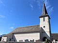
Saint Martin Church

Fallen memorial
_1.jpg)
_1.jpg)
Economy and Infrastructure
Uzer has a rural character. In addition to modest tourism offers, there are four farms in the community (cattle breeding, grain cultivation).
Uzer is located away from the nationally important traffic axes. There is a connection to the trunk road network via the nearby town of Bagnères-de-Bigorre . The nearest train station is in Capvern, 15 kilometers away . on the Toulouse – Bayonne railway line .
supporting documents
- ↑ Michel Grosclaude and Jean-Francois Le Nail with reference to the work of Jacques Boisgontier: "Dictionnaire toponymique des communes des Hautes-Pyrénées, Tarbes, Conseil Général des Hautes-Pyrénées, 2000" ( Toponymic Dictionary of the Communes of the Hautes-Pyrénées )
- ↑ Uzer on cassini.ehess.fr
- ↑ Uzer on insee.fr
- ↑ Farms on annuaire-mairie.fr (French)