
Mauvezin (Hautes-Pyrénées)
| Mauvezin | ||
|---|---|---|
.svg)
|
|
|
| region | Occitania | |
| Department | Hautes-Pyrénées | |
| Arrondissement | Bagneres-de-Bigorre | |
| Canton | La Vallée de l'Arros et des Baïses | |
| Community association | Communauté de communes du Plateau de Lannemezan | |
| Coordinates | 43 ° 7 ' N , 0 ° 17' E | |
| height | 297-574 m | |
| surface | 10 km 2 | |
| Residents | 234 (January 1, 2017) | |
| Population density | 23 inhabitants / km 2 | |
| Post Code | 65130 | |
| INSEE code | 65306 | |
 Mauvezin with the local castle |
||

Mauvezin is a French commune with 234 inhabitants (as of January 1, 2017) in the Hautes-Pyrénées department in the Occitanie region . It belongs to the Arrondissement of Bagnères-de-Bigorre and the canton of La Vallée de l'Arros et des Baïses .
Neighboring municipalities are Gourgue in the north-west, Ricaus in the north, Péré and Lutilhous in the north-east, Capvern in the east, Benqué-Molère in the south, Bonnemazon in the south-west and Artiguemy in the west.
Population development
| year | 1962 | 1968 | 1975 | 1982 | 1990 | 1999 | 2008 | 2015 |
|---|---|---|---|---|---|---|---|---|
| Residents | 220 | 230 | 220 | 226 | 209 | 188 | 226 | 235 |
Attractions
- Mauvezin Castle
- church
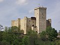
Castle of Mauvezin
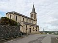
church
.JPG)
.JPG)
Web links
Commons : Mauvezin - collection of images, videos and audio files