Montgaillard (Hautes-Pyrénées)
|
Montgaillard Montgalhard |
||
|---|---|---|

|
|
|
| region | Occitania | |
| Department | Hautes-Pyrénées | |
| Arrondissement | Bagneres-de-Bigorre | |
| Canton | La Haute-Bigorre | |
| Community association | Haute-Bigorre | |
| Coordinates | 43 ° 8 ' N , 0 ° 7' E | |
| height | 419-602 m | |
| surface | 9.64 km 2 | |
| Residents | 850 (January 1, 2017) | |
| Population density | 88 inhabitants / km 2 | |
| Post Code | 65200 | |
| INSEE code | 65320 | |
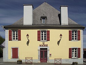
 Town hall (Mairie) of Montgaillard |
||
Montgaillard ( Occitan : Montgalhard ) is a French commune with 850 inhabitants (as of January 1, 2017) in the Hautes-Pyrénées department in the Occitanie region . It belongs to the arrondissement of Bagnères-de-Bigorre and the canton of La Haute-Bigorre .
geography
Montgaillard is located in the historic province of Bigorre on the Adour River , about twelve kilometers south-southeast of Tarbes and six kilometers north-northwest of the administrative capital Bagnères-de-Bigorre .
The neighboring communities of Montgaillard are Hiis in the north, vielle-Adour in the north and northeast, Orignac in the east, Antist in the southeast, Ordizan in the south and southeast, Trébons in the south, Astugue in the southwest and Loucrup in the west.
Population development
| year | 1962 | 1968 | 1975 | 1982 | 1990 | 1999 | 2006 | 2011 | 2016 |
| Residents | 614 | 629 | 628 | 695 | 737 | 724 | 723 | 791 | 847 |
| Source: Cassini and INSEE | |||||||||
Attractions
- Saint-Hilaire church from the 19th century
Web links
Commons : Montgaillard - collection of images, videos and audio files

