
Chelle-Spou
|
Chelle-Spou Shèla Espon |
||
|---|---|---|
.svg)
|
|
|
| region | Occitania | |
| Department | Hautes-Pyrénées | |
| Arrondissement | Bagneres-de-Bigorre | |
| Canton | La Vallée de l'Arros et des Baïses | |
| Community association | Plateau de Lannemezan | |
| Coordinates | 43 ° 8 ' N , 0 ° 15' E | |
| height | 282-492 m | |
| surface | 4.58 km 2 | |
| Residents | 119 (January 1, 2017) | |
| Population density | 26 inhabitants / km 2 | |
| Post Code | 65130 | |
| INSEE code | 65143 | |
_1.jpg) Mairie Chelle-Spou |
||

Chelle-Spou ( Occitan Shèla Espon ) is a French commune with 119 inhabitants (as of January 1, 2017) in the Hautes-Pyrénées department in the Occitania region (until 2015 Midi-Pyrénées ). The municipality belongs to the arrondissement of Bagnères-de-Bigorre and to the municipality association Plateau de Lannemezan, founded in 2016 . The inhabitants are called Chespouais .
geography
_1.jpg)
The municipality of Chelle-Spou is located in the north of the Bigorre landscape in the foothills of the Pyrenees and in the southwest of the Lannemezan plateau , about twelve kilometers northwest of Lannemezan and about 16 kilometers southeast of the departmental capital, Tarbes . The community area of 4.58 km² is bordered to the east by the Arros River . The community consists of the villages of Chelle on a mountain spur at 489 m above sea level and Spou at 300 m above sea level at the mouth of the Arriou darré in the Arros, the hamlet of Sayrou and several individual farms. Chelle-Spou is surrounded by the neighboring communities Ozon in the north, Ricaud in the northeast, Gourgue in the east, Artiguemy in the south and Cieutat in the west.
Place name
The likely Latin etymology of Chelle is Scala Spei , which means something like Crown of Hope . As for Spou, it comes from the Gascon Espon what the Latin Sponda descended and as much as limit the tilt means. The municipality was originally called Chelle-Dessus , then Chelle and Cheile between 1790 and 1801 and only officially Chelle-Spou from 1806 .
Population development
| year | 1962 | 1968 | 1975 | 1982 | 1990 | 1999 | 2006 | 2016 |
| Residents | 125 | 114 | 103 | 95 | 95 | 91 | 89 | 119 |
| Sources: Cassini and INSEE | ||||||||
Attractions
- Assumption Church ( Église de l'Assomption )
- several hall crosses
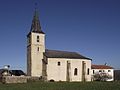
Ascension Church

one of the hall crosses

Fallen memorial
.JPG)
_1.jpg)
_1.jpg)
Economy and Infrastructure
Chelle-Spou has a rural character. Twelve farms are located in the community (grain and feed cultivation, cattle breeding, dairy farming).
In Tournay , six kilometers away, there are connections to the trunk road network and the A 64 autoroute . Tournay is also the closest train station - on the Toulouse – Bayonne railway line .
supporting documents
- ↑ Brief history on the presentation of the community association (French)
- ↑ Chelle-Spou on cassini.ehess.fr (French)
- ↑ Chelle-Spou on INSEE
- ↑ Farms on annuaire-mairie.fr (French)