
Gouaux
|
Gouaux Guaus |
||
|---|---|---|
.svg)
|
|
|
| region | Occitania | |
| Department | Hautes-Pyrénées | |
| Arrondissement | Bagneres-de-Bigorret | |
| Canton | Neste, Aure and Louron | |
| Community association | Aure Louron | |
| Coordinates | 42 ° 52 ' N , 0 ° 22' E | |
| height | 852-1,687 m | |
| surface | 6.02 km 2 | |
| Residents | 55 (January 1, 2017) | |
| Population density | 9 inhabitants / km 2 | |
| Post Code | 65440 | |
| INSEE code | 65205 | |
_1.jpg) Mairie Gouaux |
||

Gouaux ( Occitan : Guaus ) is a French commune with 55 inhabitants (as of January 1, 2017) in the Hautes-Pyrénées department in the Occitanie region (until 2015 Midi-Pyrénées ). The municipality belongs to the arrondissement of Bagnères-de-Bigorre and to the municipality association Aure Louron, founded in 1995 . The inhabitants are called Gouaussiens .
geography
The municipality of Gouaux is located in the Bigorre landscape in the Pyrenees , 30 kilometers south of Lannemezan and about 20 kilometers north of the border with Spain . The 6.02 km² municipal area extends around a side valley of the Neste d'Aure with the eponymous village of Gouaux at approx. 950 meters above sea level, flanked by several mountain peaks:
- Pic de Pignaué 1326 m
- Peyre Blanque 1360 m
- Pla de la Coume Sourde 1453 m
On the eastern and southern municipal boundaries, several peaks reach heights of over 1,600 m. Numerous mountain streams in the municipality come together in the Ruisseau de Gouaux , which flows to the Neste d'Aure. Forest dominates over 90% of the municipal area, only a few clearing islands are used as pastures. The hamlet of Granges du Val belongs to the municipality of Gouaux . Gouaux is surrounded by the neighboring communities of Lançon in the north, Bordères-Louron in the northeast, Avajan in the east, vielle-Louron in the southeast, Grailhen and south, Guchan in the southwest (point of contact), Bazus-Aure in the west and Grézian in the northwest.
Place name
In 1387 the Latin place name De Goausio appeared for the first time . This was followed by the spellings in loco de Goaus , Gouaux en Aure (1744), Gouaux d'Aure (1749) and 1790 Goueux and the name Gouaux, which is still valid today .
Population development
| year | 1962 | 1968 | 1975 | 1982 | 1990 | 1999 | 2006 | 2017 | |
|---|---|---|---|---|---|---|---|---|---|
| Residents | 42 | 42 | 34 | 46 | 62 | 58 | 68 | 55 | |
| Sources: Cassini and INSEE | |||||||||
Attractions
- Notre-Dame parish church (since 1857), reconstructed at the beginning of the 19th century, with a neoclassical portal surmounted by a triangular gable and a nave enlarged in 1814; Parish church since 1857
- Romanesque chapel Saint-Étienne with changes in the 16th century, Monument historique
- Lavoir
- Hall crosses and fountains

Notre-Dame church

Saint-Etienne chapel
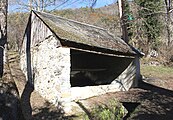
Lavoir Gouaux

Fountain
_2.jpg)
_2.jpg)
_1.jpg)
_1.jpg)
Economy and Infrastructure

Tourism (camping) and agriculture dominate in Gouaux. There are two farms in the community (sheep and goat farming with cheese dairy, vegetable growing).
Gouaux can only be reached from the D 929 trunk road from Lannemezan to Bielsa, Spain .
supporting documents
- ^ "Dictionnaire toponymique des communes des Hautes-Pyrénées, Tarbes, Conseil Général des Hautes-Pyrénées, 2000" ( Toponymic Dictionary of the Communes of the Hautes-Pyrénées ) by Michel Grosclaude and Jean-Francois Le Nail ( ISBN 2-9514810-1-2 )
- ↑ Gouaux on cassini.ehess.fr.
- ↑ Gouaux on insee.fr.
- ^ Entry in the Base Mérimée of the Ministry of Culture. Retrieved December 12, 2018 (French).
- ↑ Farms on annuaire-mairie.fr (French).