
Trébons
|
Trébons Trebons |
||
|---|---|---|
.svg)
|
|
|
| region | Occitania | |
| Department | Hautes-Pyrénées | |
| Arrondissement | Bagneres-de-Bigorre | |
| Canton | La Haute-Bigorre | |
| Community association | Haute-Bigorre | |
| Coordinates | 43 ° 6 ′ N , 0 ° 7 ′ E | |
| height | 456-773 m | |
| surface | 10.19 km 2 | |
| Residents | 760 (January 1, 2017) | |
| Population density | 75 inhabitants / km 2 | |
| Post Code | 65200 | |
| INSEE code | 65451 | |

Trébons ( Occitan : Trebons ) is a French commune with 760 inhabitants (as of January 1, 2017) in the Hautes-Pyrénées department in the Occitanie region . It belongs to the arrondissement of Bagnères-de-Bigorre and the canton of La Haute-Bigorre . The inhabitants are called Trébonnais .
geography
Trébons is located in the historic province of Bigorre on the Adour River , about 15 kilometers south-southeast of Tarbes and about four kilometers north-northwest of the administrative capital Bagnères-de-Bigorre .
The neighboring municipalities of Trébons are Montgaillard in the north, Ordizan in the east and northeast, Pouzac in the south and southeast, Labassère in the south and southwest and Astugue in the west.
Population development
| year | 1962 | 1968 | 1975 | 1982 | 1990 | 1999 | 2006 | 2011 | 2016 |
| Residents | 711 | 709 | 651 | 721 | 735 | 684 | 648 | 697 | 754 |
| Source: Cassini and INSEE | |||||||||
Attractions
- Saint-Pierre church
- Notre-Dame chapel in Hourcadère
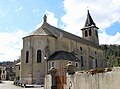
Saint-Pierre church

Notre-Dame chapel
_1.jpg)
_1.jpg)
Personalities
- Jacques Baseilhac (1873–1903), painter and lithographer
- Joseph Brau (1891–1975), radiologist and resistance fighter (1943–1945) moved to Buchenwald Concentration