
Hèches
|
Hèches Hèishas |
||
|---|---|---|
.svg)
|
|
|
| region | Occitania | |
| Department | Hautes-Pyrénées | |
| Arrondissement | Bagneres-de-Bigorre | |
| Canton | Neste, Aure and Louron | |
| Community association | Plateau de Lannemezan | |
| Coordinates | 43 ° 1 ′ N , 0 ° 22 ′ E | |
| height | 564-1,900 m | |
| surface | 35.44 km 2 | |
| Residents | 616 (January 1, 2017) | |
| Population density | 17 inhabitants / km 2 | |
| Post Code | 65250 | |
| INSEE code | 65218 | |
_1.jpg) Mairie Hèches |
||

Hèches ( Occitan : Hèishas ) is a French commune with 616 inhabitants (as of January 1, 2017) in the Hautes-Pyrénées department in the Occitanie region . It belongs to the Arrondissement of Bagnères-de-Bigorre and the community association Plateau de Lannemezan, which was founded in 2016 . The inhabitants are called Héchois .
geography
Hèches 
Hechettes 
Rebouc
_2.jpg)
_4.jpg)
_5.jpg)
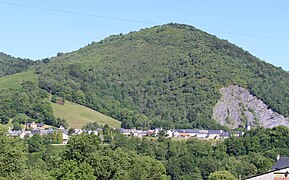
The municipality of Hèches is located in the Pyrenees in the Bigorre an der Neste region , about ten kilometers south of Lannemezan and 45 kilometers north of the border with Spain . The municipal area of 35.44 km² extends over a five-kilometer section of the Nestetal as well as several side valleys and the wooded mountains in between, which in the north of the municipality reach heights of over 1000 meters, in the south of over 1500 meters above sea level. The highest point is marked by the Cap de Castillon at 1900 m in the southwestern tip of the municipality. To the left or to the west, the Neste is accompanied by the Canal de la Neste , which, via the Lannemezan plateau , feeds other rivers that have little water in summer. The municipality includes the three villages of Hèches, Héchettes and Rebouc as well as several small hamlets and individual mountain farms.
The highest mountain peaks in the municipality of Hèches:
|
west of the Nestetal:
|
east of the Nestetal:
|
_1.jpg)
Neste bridge in Rebouc
|
_3.jpg)
Canal de la Neste in Hèches
|
Hèches is surrounded by the neighboring communities of Bazus-Neste in the north, Mazouau , Gazave and Bize in the northeast, Nistos in the east, Sarrancolin in the south, Beyrède-Jumet-Camous in the southwest, Esparros in the west and Labastide and Lortet in the northwest.
Place name
The place was first mentioned in 1333 as Feyssas . In 1387 the Latin name De Fexis followed . Finally, the name Heches appeared on a Cassini card at the end of the 18th century . In Gaskognischen the place was called hèisha = strip of land .
Population development
| year | 1962 | 1968 | 1975 | 1982 | 1990 | 1999 | 2007 | 2016 |
|---|---|---|---|---|---|---|---|---|
| Residents | 664 | 2627 | 548 | 536 | 553 | 580 | 620 | 611 |
| Source: Cassini and INSEE | ||||||||
_1.jpg)
Attractions
_1.jpg)
_2.jpg)
- Saint-Pierre church in the village of Hèches
- Saint-Ebons church in Durf Rebouc
- Saint-Pierre church in the village of Hèchettes
- Remains of the castle tower
- several wash houses ( lavoirs )
- two memorials to those who fell in the world wars
- several refuges for mountain hikers
- several wayside crosses

Saint-Pierre church in the village of Hèche

Saint-Pierre church in the village of Hèchettes

Saint-Ebons church in Durf Rebouc
_1.jpg)
_1.jpg)
_1.jpg)

Lavoir in Hèches

Lavoir in Héchettes

Lavoir in Rebouc
Lavoir in the Léchan district
_1.jpg)
_1.jpg)
_1.jpg)
_2.jpg)
Economy and Infrastructure
In Hèches there is a primary school, a post office and a few small shops. There are 23 farms in the community (growing grain and vegetables, raising cattle, goats and sheep). In addition, the tourism sector is developing in the form of holiday home rentals.
The D 929 trunk road from Lannemezan to Bielsa, Spain, runs through Hèches in a north-south direction . There are other road connections to Bazus-Neste , Mazouau , Esparros , Labastide and Lortet . In the town of Lannemezan, ten kilometers away, there is a connection to the A 64 autoroute ; Lannemezan station is on the Toulouse – Bayonne railway line . Following the Nestetal was the railway line from Lannemezan to Arreau / Cadéac ( Ligne de Lannemezan à Arreau - Cadéac ) from 1897 to 1969 . On this route, Kèches had a train station and the district of Rebouc had a stop

Post Office Hèches

Former Hèches train station
_1.jpg)
_2.jpg)
supporting documents
- ^ "Dictionnaire toponymique des communes des Hautes-Pyrénées, Tarbes, Conseil Général des Hautes-Pyrénées, 2000" ( Toponymic Dictionary of the Communes of the Hautes-Pyrénées ) by Michel Grosclaude and Jean-Francois Le Nail ( ISBN 2-9514810-1-2 )
- ↑ Hèches on cassini.ehess.fr (French)
- ↑ Hèches on insee.fr
- ↑ Farms on annuaire-mairie.fr