
Sainte-Marie-d'Attez
| Sainte-Marie-d'Attez | ||
|---|---|---|
|
||
| region | Normandy | |
| Department | Your | |
| Arrondissement | Bernay | |
| Canton | Breteuil | |
| Community association | Interco Normandie Sud Eure | |
| Coordinates | 48 ° 48 ' N , 0 ° 57' E | |
| height | 155-189 m | |
| surface | 26.04 km 2 | |
| Residents | 599 (January 1, 2017) | |
| Population density | 23 inhabitants / km 2 | |
| Post Code | 27160 | |
| INSEE code | 27578 | |

Sainte-Marie-d'Attez is a French municipality with 599 inhabitants (as of January 1 2017) in the department of Eure in the region of Normandy . It belongs to the Arrondissement of Bernay and the cantons of Breteuil and is a member of the Interco Normandie Sud Eure municipal association .
geography
Sainte-Marie-d'Attez is located about 28 kilometers southwest of Évreux on the Iton . Sainte-Marie-d'Attez is surrounded by the neighboring communities of Mesnils-sur-Iton in the north and east, L'Hosmes in the south-east, Tillières-sur-Avre in the south and south-east, Piseux in the south and Breteuil in the west.
history
On January 1, 2016, the previously independent municipalities of Dame-Marie , Saint-Nicolas-d'Attez and Saint-Ouen-d'Attez were merged to form the new commune ( commune nouvelle ) Sainte-Marie-d'Attez. The seat of this newly created regional authority is in the district of Saint-Ouen-d'Attez.
structure
| District | former INSEE code |
Area (km²) | Population (2017) |
|---|---|---|---|
| Lady-Marie | 27195 | 11.37 | 124 |
| Saint-Nicolas-d'Attez | 27573 | 5.16 | 157 |
| Saint-Ouen-d'Attez (administrative headquarters) | 27578 | 9.51 | 318 |
Attractions
Lady-Marie
- Notre-Dame Church, historic monument since 1961
Saint-Ouen-d'Attez
- Menhir Pierre de la Joure , Monument historique since 1934
- Saint-Ouen church
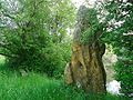
Menhir in Saint-Ouen-d'Attez

Notre-Dame church in Dame-Marie

Saint-Ouen church in Saint-Ouen-d'Attez

_06.JPG)

Personalities
- Augustin Théodule Ribot (1823–1891), painter, born in Saint-Nicolas-d'Attez