Corneillan
|
Corneillan Cornelhan |
||
|---|---|---|

|
|
|
| region | Occitania | |
| Department | Gers | |
| Arrondissement | Mirande | |
| Canton | Adour-Gersoise | |
| Community association | Aire-sur-l'Adour | |
| Coordinates | 43 ° 39 ′ N , 0 ° 11 ′ E | |
| height | 85-160 m | |
| surface | 8.47 km 2 | |
| Residents | 146 (January 1, 2017) | |
| Population density | 17 inhabitants / km 2 | |
| Post Code | 32400 | |
| INSEE code | 32108 | |
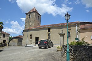
 Notre-Dame village church |
||
Corneillan ( Gascon : Cornelhan ) is a French municipality with 146 inhabitants (at January 1, 2017) in the department of Gers in the region Okzitanien ; it belongs to the arrondissement of Mirande and to the community association Communauté de communes d'Aire-sur-l'Adour .
geography
Corneillan is located around 12 kilometers southeast of the small town of Aire-sur-l'Adour in the west of the Gers department. The main bodies of water are the Adour River , Claquessot Stream and two ponds. The most important supraregional traffic connection is the Autoroute A65 (part of Europastraße 7 ) , which runs more than 10 kilometers west of the municipality . The nearest train station is in Aire-sur-l'Adour.
Corneillan is surrounded by the neighboring communities of Gée-Rivière in the north, Saint-Germé in the northeast, Saint-Mont in the east, Labarthète in the south, Lannux in the southwest and west and Bernède in the northwest.
history
The rights and freedoms of the residents of the place were recorded by the feudal lord in a document in 1142 (French: charte de coutumes). Corneillan was the seat of the Dukes of Corneillan.
Population development
| year | 1793 | 1831 | 1841 | 1911 | 1921 | 1962 | 1968 | 1975 | 1982 | 1990 | 1999 | 2006 | 2012 |
| Residents | 418 | 448 | 520 | 416 | 303 | 153 | 140 | 121 | 114 | 115 | 147 | 141 | 136 |
| Sources: Cassini and INSEE | |||||||||||||
Attractions
- Church of Our Lady of the 11th century
