Monclar-sur-Losse
|
Monclar-sur-Losse Montclar sus l'Òssa |
||
|---|---|---|
|
|
||
| region | Occitania | |
| Department | Gers | |
| Arrondissement | Mirande | |
| Canton | Pardiac-Rivière-Basse | |
| Community association | Cœur d'Astarac en Gascogne | |
| Coordinates | 43 ° 32 ' N , 0 ° 20' E | |
| height | 164-267 m | |
| surface | 10.47 km 2 | |
| Residents | 106 (January 1, 2017) | |
| Population density | 10 inhabitants / km 2 | |
| Post Code | 32300 | |
| INSEE code | 32265 | |
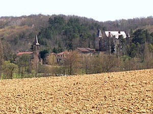
 View of the community |
||
Monclar-sur-Losse ( Gascon : Montclar sus l'Ossa) is a French municipality with 106 inhabitants (at January 1, 2017) in the department of Gers in the region Occitania (2015 Midi-Pyrenees ). It belongs to the Arrondissement Mirande and the municipality of Cœur d'Astarac en Gascogne . The residents call themselves Monclarais / Monclaraises .
geography
Monclar-sur-Losse is located about six kilometers west-northwest of Mirande and 24 kilometers southwest of Auch in the south of the Gers department. The community consists of hamlets, numerous scattered settlements and individual farmsteads. The river Osse crosses the municipality in a northerly direction.
Neighboring communities are Montesquiou in the north, Mirande in the northeast, Saint-Martin in the east and southeast, Saint-Maur in the south, Bars in the southwest and Pouylebon in the west.
Population development
| year | 1793 | 1821 | 1962 | 1968 | 1975 | 1982 | 1990 | 1999 | 2006 | 2011 | 2016 |
| Residents | 307 | 337 | 141 | 118 | 113 | 126 | 125 | 102 | 130 | 111 | 104 |
| Sources: Cassini and INSEE | |||||||||||
