Bellegarde (Gers)
|
Bellegarde Belagarda e Adolins |
||
|---|---|---|
|
|
||
| region | Occitania | |
| Department | Gers | |
| Arrondissement | Mirande | |
| Canton | Astarac gimone | |
| Community association | Val de Gers | |
| Coordinates | 43 ° 21 ' N , 0 ° 27' E | |
| height | 212-315 m | |
| surface | 14.39 km 2 | |
| Residents | 190 (January 1, 2017) | |
| Population density | 13 inhabitants / km 2 | |
| Post Code | 32140 | |
| INSEE code | 32041 | |
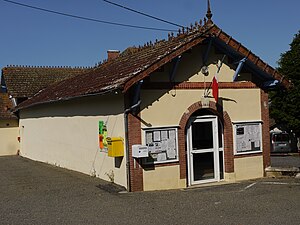
 Bellegarde Municipal House (Mairie) |
||
Bellegarde ( Gascon : Bela Garda e Adolins) is a French municipality with 190 inhabitants (at January 1, 2017) in the department of Gers in the region Occitania (2015 Midi-Pyrénées ); it belongs to the arrondissement of Mirande and the municipal association Val de Gers . The residents call themselves Bellegardais / Bellegardaises .
geography
Bellegarde is located around 20 kilometers southeast of Mirande and 25 kilometers south of Auch in the south of the Gers department. The community consists of the hamlet of Les Adoulins, numerous scattered settlements and individual farms. Part of the municipality forms an enclave surrounded by the municipality of Moncorneil-Grazan. The Arrats river crosses the municipality in a northerly direction and in parts forms the eastern municipal boundary.
Neighboring communities are Moncorneil-Grazan in the north and northeast, Betcave-Aguin in the northeast, Meilhan in the east, Sère in the south, Bézues-Bajon in the southwest and Masseube in the west.
Population development
| year | 1831 | 1962 | 1968 | 1975 | 1982 | 1990 | 1999 | 2006 | 2011 | 2016 |
| Residents | 485 | 232 | 203 | 165 | 148 | 150 | 136 | 159 | 171 | 187 |
| Sources: Cassini, Bellegarde Cassini, Adolins and INSEE | ||||||||||
