
Speedometers
| Speedometers | ||
|---|---|---|
|
||
| region | Occitania | |
| Department | Gers | |
| Arrondissement | Mirande | |
| Canton | Astarac gimone | |
| Community association | Val de Gers | |
| Coordinates | 43 ° 28 ′ N , 0 ° 40 ′ E | |
| height | 197-304 m | |
| surface | 9.61 km 2 | |
| Residents | 98 (January 1, 2017) | |
| Population density | 10 inhabitants / km 2 | |
| Post Code | 32260 | |
| INSEE code | 32438 | |
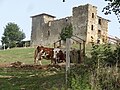
 Mairie from Tachoires |
||

Tachoires (on Occitan Taishoèras ) is a French municipality with 98 inhabitants (at January 1, 2017) in the department of Gers in the region Occitania . It belongs to the arrondissement of Mirande and the canton of Astarac-Gimone .
Neighboring municipalities are Monferran-Plavès in the northwest, Lamaguère in the north, Simorre in the east, Betcave-Aguin in the southeast, Moncorneil-Grazan in the south, Pouy-Loubrin in the southwest and Seissan in the west.
Population development
| year | 1962 | 1968 | 1975 | 1982 | 1990 | 1999 | 2008 | 2016 |
|---|---|---|---|---|---|---|---|---|
| Residents | 112 | 106 | 98 | 102 | 100 | 101 | 97 | 97 |

Chapelle des Téoulès

Saint-Pierre church
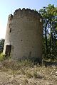
Remains of a windmill
Château de Laumède


Web links
Commons : Tachoires - collection of images, videos and audio files