Masseube
|
Masseube Masseuva |
||
|---|---|---|

|
|
|
| region | Occitania | |
| Department | Gers | |
| Arrondissement | Mirande | |
| Canton | Astarac-Gimone (main town) | |
| Community association | Val de Gers | |
| Coordinates | 43 ° 26 ' N , 0 ° 35' E | |
| height | 188-306 m | |
| surface | 21.03 km 2 | |
| Residents | 1,520 (January 1, 2017) | |
| Population density | 72 inhabitants / km 2 | |
| Post Code | 32140 | |
| INSEE code | 32242 | |
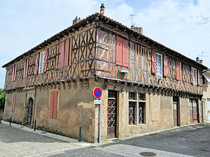
 Half-timbered house on rue du commerce |
||
Masseube ( Gaskognisch : Masseuva ) is a French commune with 1520 inhabitants (as of January 1, 2017) in the south-west of the country. Masseube belongs to Région Okzitanien and the department of Gers . The municipality is located in the arrondissement of Mirande and belongs to the canton of Astarac-Gimone . Masseube was the main town ( chef-lieu ) of the canton of Masseube until 2015 . The inhabitants are called Massylvains .
geography
The place is about 24 kilometers south of Auch . The river Gers , after which the department was named, flows through Masseube .
history
Masseube is a bastide founded by the abbot of the Cistercian monastery of L'Escaladieu and Count Bernard IV of Armagnac in 1274. During the time of the German occupation of France from 1941 a concentration camp existed here.
| 1962 | 1968 | 1975 | 1982 | 1990 | 1999 | 2006 | 2017 |
|---|---|---|---|---|---|---|---|
| 1230 | 1316 | 1309 | 1376 | 1453 | 1391 | 1519 | 1520 |
Attractions
- Saint-Christophe Church (built towards the end of the 13th century)
- Half-timbered houses on the promenade ( Monument historique since 1979 )
Personalities
- Jean-Marie Ducos (1758–1843), politician
