Gée-Rivière
|
Gée-Rivière Gea e Ribèra |
||
|---|---|---|
|
|
||
| region | Occitania | |
| Department | Gers | |
| Arrondissement | Mirande | |
| Canton | Adour-Gersoise | |
| Community association | Aire-sur-l'Adour | |
| Coordinates | 43 ° 40 ′ N , 0 ° 11 ′ E | |
| height | 83-92 m | |
| surface | 2.74 km 2 | |
| Residents | 46 (January 1, 2017) | |
| Population density | 17 inhabitants / km 2 | |
| Post Code | 32720 | |
| INSEE code | 32145 | |
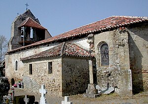
 Saint-Sernin church |
||
Gée-Rivière ( Gaskognisch : Gea e Ribèra ) is a French commune with 46 inhabitants (as of January 1, 2017) in the Gers department in the Occitanie region ; it belongs to the arrondissement of Mirande and to the community association Communauté de communes d'Aire-sur-l'Adour .
geography
Gée-Rivière is located around seven kilometers southeast of the small town of Aire-sur-l'Adour in the west of the Gers department. The main bodies of water are the Adour River and Le Jarras Stream . The most important supraregional transport connection is the A65 autoroute (part of Europastraße 7 ) running around 10 kilometers west of the municipality . The nearest train station is in Aire-sur-l'Adour.
Gée-Rivière is surrounded by the neighboring communities of Barcelonne-du-Gers in the north and northeast, Saint-Germé in the southeast, Corneillan in the south and Bernède in the west.
history
In the 19th century, the remains of a villa from the Gallo-Roman period were discovered. The place was first mentioned by name in 1222 under the name Gaius . Today's municipality was created by the merger of the hamlets of Gée and Rivière in 1822.
Population development
| year | 1793 | 1800 | 1831 | 1861 | 1911 | 1962 | 1968 | 1975 | 1982 | 1990 | 1999 | 2006 | 2017 |
| Residents | 127 | 88 | 172 | 147 | 97 | 44 | 44 | 38 | 39 | 51 | 51 | 45 | 46 |
| Sources: Cassini and INSEE | |||||||||||||
Attractions
- Church Saint Saturnin (Saint-Sernin) from the 9th century
- two old houses from 1818
- former mill
