
Boucagnères
|
Boucagnères Bocanhera |
||
|---|---|---|
.svg)
|
|
|
| region | Occitania | |
| Department | Gers | |
| Arrondissement | Mirande | |
| Canton | Also-3 | |
| Community association | Val de Gers | |
| Coordinates | 43 ° 34 ' N , 0 ° 37' E | |
| height | 150-273 m | |
| surface | 6.16 km 2 | |
| Residents | 209 (January 1, 2017) | |
| Population density | 34 inhabitants / km 2 | |
| Post Code | 32550 | |
| INSEE code | 32060 | |
| Website | http://www.boucagneres.fr/index.php/fr/ | |
 Boucagnères village square |
||

Boucagnères ( Gascon Bocanhera ) is a French municipality with 209 inhabitants (at January 1, 2017) in the department of Gers in the region Okzitanien ; it belongs to the arrondissement of Mirande . Its inhabitants call themselves Boucagnérois / Boucagnéroises .
geography
Boucagnères is located around 10 kilometers south-southeast of the city Auch in the south of the Gers department. The Gers crosses Boucagnères from south to north. The community consists of the village of Boucagnères, several groups of houses and individual farms. In terms of traffic, the community is on the D929.
history
The place arose around a mill in the Middle Ages. In 1158 a gentleman from Bocaiera is mentioned in Gimont's book of documents. In the Middle Ages, the place was within the county of Astarac, which was part of the province of Gascony. From 1793 to 1801, all districts belonged to the Auch district. In addition, Boucagnères and Montarrabé were part of the canton of Seissan from 1793 to 1801, while Gramont was assigned to the canton of Auch. From 1801 to 1824 Boucagnères and Gramont were in the canton of Auch-Sud. Today's district of Montarrabé, on the other hand, is in the canton of Saramon. From 1824, all three districts belonged to the canton of Auch-Sud and were part of the canton of Auch-Sud-Est-Seissan from 1973 to 2015 . The entire municipality has been assigned to the arrondissement Auch since 1801. In 1824 the previously independent municipality of Gramont (1821: 38 inhabitants) and Montarrabé (today Montarabé; 1821: 56 inhabitants) were incorporated into the municipality of Boucagnères.
Population development
| year | 1806 | 1821 | 1861 | 1866 | 1881 | 1911 | 1921 | 1962 | 1968 | 1975 | 1982 | 1990 | 1999 | 2006 | 2014 |
| Residents | 217 | 225 | 200 | 176 | 221 | 140 | 110 | 101 | 107 | 91 | 125 | 142 | 141 | 135 | 165 |
| Sources: Cassini and INSEE; today's municipal area | |||||||||||||||
Attractions
- Castle from the 12th century (with extensions from the 16th century) and chapel Saint-Laurent in Petit-Gramont (private property)
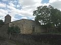
- Saint-Germier village church from the 18th century with altar
- Memorial to the Fallen
- numerous wayside crosses
- old watermill
- medieval castle tower, later used as a dovecote

Town hall (Mairie) of Boucagnères

Saint-Germier village church
former castle of Boucagnères - walls and tower

former castle tower and dovecote

Memorial to the Fallen

The Gers at Boucagnères


Web links
- Location of the place in France
- Boucagnères on the side of the IGN
- Village church and castle chapel
- Brief information about the municipality (French)